Download
1 / 2
20 likes | 139 Views
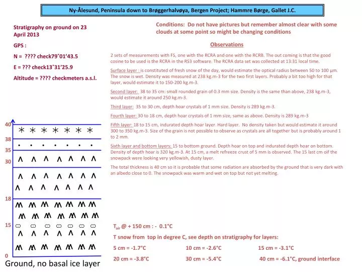
Ny-Ålesund, Peninsula down to Brøggerhalvøya , Bergen Project; Hammre Børge, Gallet J.C. Conditions: Do not have pictures but remember almost clear with some clouds at some point so might be changing conditions. Stratigraphy on ground on 23 April 2013 GPS :

E N D
Ny-Ålesund, Peninsula down to Brøggerhalvøya, Bergen Project; Hammre Børge, Gallet J.C. Conditions: Do not have pictures but remember almost clear with some clouds at some point so might be changing conditions Stratigraphy on ground on 23 April 2013 GPS : N = ???? check79˚01’43.5 E = ??? check13˚31’25.9 Altitude = ???? checkmetersa.s.l. Observations 2 sets of measurements with FS, one with the RCRA and one with the RCRB. The out coming is that the good cosine to be used is the RCRA in the RS3 software. The RCRA data set was collected at 13:31 local time. Surface layer : is constituted of fresh snow of the day, would estimate the optical radius between 50 to 100 µm. The snow is wet. Density was measured at 238 kg.m-3 for the two first layers. Probably a bit too high for that layer, would estimate it to 150-200 kg.m-3. Second layer: 38 to 35cm: small rounded grain of 0.3 mm size. Density is the same than above, 238 kg.m-3, would estimate it around 250 kg.m-3. Third layer:35 to 30 cm, depth hoar crystals of 1 mm size. Density is 289 kg.m-3. Fourth layer: 30 to 18 cm, depth hoar crystals of 1 mm size, same as above. Density is 289 kg.m-3 Fifth layer: 18 to 15 cm, indurated depth hoar layer. Hard layer. No density taken but would estimate it around 300 to 350 kg.m-3. Size of the grain is not possible to observe as crystals are all together but is probably around 1 to 2 mm. Sixth layer and bottom layers: 15 to bottom ground. Depth hoar on top and indurated depth hoar on bottom. Density of depth hoar is 320 kg.m-3. At 15 cm, a melt refreeze crust of 5 mm is observed. The 15 last cm oif the snowpack were looking very yellowish, dusty layer. The total thickness is 40 cm so it is probable that some radiation are absorbed by the ground that is very dark with an albedo close to 0. The snowpack was warm and wet on top but not yet melting. 40 38 35 30 18 15 Tair@ + 150 cm : - 0.1°C T snow from top in degree C, see depth on stratigraphy for layers: 5 cm = -1.7°C 10 cm = -2.6°C 15 cm = -3.1°C 20 cm = -3.8°C 30 cm = -5.4°C 40 cm = -6.1°C, ground interface 0 Ground, no basal ice layer
Albedo data på April 23 2013 påPeninsula nedBrøggerhlavøya RCRA cosine collector data er den rikitge data satt till å bruke !!!!