Download
1 / 1
10 likes | 87 Views
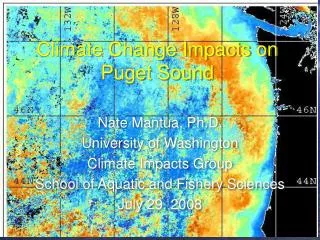
Climate Change Effects on Surface Hydrology In the Puget Sound Basin. Lan Cuo 1 , Nathalie Voisin 1 , Julie Vano 1 , Marketa E.McGuire 2 , Eric Salathe 2 , Dennis P. Lettenmaier 1,2 1 Department of Civil and Environmental Engineering, University of Washington

E N D
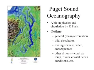
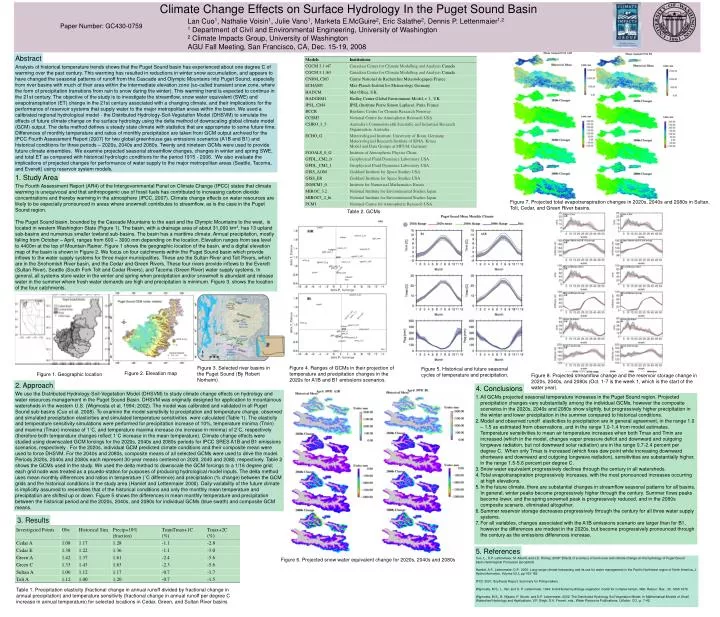
Climate Change Effects on Surface Hydrology In the Puget Sound Basin Lan Cuo1, Nathalie Voisin1, Julie Vano1, Marketa E.McGuire2, Eric Salathe2, Dennis P. Lettenmaier1,2 1 Department of Civil and Environmental Engineering, University of Washington 2 Climate Impacts Group, University of Washington AGU Fall Meeting, San Francisco, CA, Dec. 15-19, 2008 Paper Number: GC430-0759 Abstract Analysis of historical temperature trends shows that the Puget Sound basin has experienced about one degree C of warming over the past century. This warming has resulted in reductions in winter snow accumulation, and appears to have changed the seasonal patterns of runoff from the Cascade and Olympic Mountains into Puget Sound, especially from river basins with much of their area within the intermediate elevation zone (so-called transient snow zone, where the form of precipitation transitions from rain to snow during the winter). This warming trend is expected to continue in the 21st century. The objective of the study is to investigate the streamflow, snow water equivalent (SWE) and evapotranspiration (ET) change in the 21st century associated with a changing climate, and their implications for the performance of reservoir systems that supply water to the major metropolitan areas within the basin. We used a calibrated regional hydrological model - the Distributed Hydrology-Soil-Vegetation Model (DHSVM) to simulate the effects of future climate change on the surface hydrology using the delta method of downscaling global climate model (GCM) output. The delta method defines a steady state climate with statistics that are appropriate to some future time. Differences of monthly temperature and ratios of monthly precipitation are taken from GCM output archived for the IPCC Fourth Assessment Report (2007) for two global greenhouse gas emissions scenarios (A1B and B1) and historical conditions for three periods – 2020s, 2040s and 2080s. Twenty and nineteen GCMs were used to provide future climate ensembles. We examine projected seasonal streamflow changes, changes in winter and spring SWE, and total ET as compared with historical hydrologic conditions for the period 1915 - 2006. We also evaluate the implications of projected changes for performance of water supply to the major metropolitan areas (Seattle, Tacoma, and Everett) using reservoir system models. 1. Study Area The Fourth Assessment Report (AR4) of the Intergovernmental Panel on Climate Change (IPCC) states that climate warming is unequivocal and that anthropogenic use of fossil fuels has contributed to increasing carbon dioxide concentrations and thereby warming in the atmosphere (IPCC, 2007). Climate change effects on water resources are likely to be especially pronounced in areas where snowmelt contributes to streamflow, as is the case in the Puget Sound region. The Puget Sound basin, bounded by the Cascade Mountains to the east and the Olympic Mountains to the west, is located in western Washington State (Figure 1). The basin, with a drainage area of about 31,000 km2, has 13 upland sub-basins and numerous smaller lowland sub-basins. The basin has a maritime climate. Annual precipitation, mostly falling from October – April, ranges from 600 – 3000 mm depending on the location. Elevation ranges from sea level to 4400m at the top of Mountain Rainer. Figure 1 shows the geographic location of the basin, and a digital elevation map of the basin is shown in Figure 2. We focus on four catchments within the Puget Sound basin which provide inflows to the water supply systems for three major municipalities. These are the Sultan River and Tolt Rivers, which are in the Snohomish River basin, and the Cedar and Green Rivers. These four rivers provide inflows to the Everett (Sultan River), Seattle (South Fork Tolt and Cedar Rivers), and Tacoma (Green River) water supply systems. In general, all systems store water in the winter and spring when precipitation and/or snowmelt is abundant and release water in the summer where fresh water demands are high and precipitation is minimum. Figure 3. shows the location of the four catchments. Figure 7. Projected total evapotranspiration changes in 2020s, 2040s and 2080s in Sultan, Tolt, Cedar, and Green River basins. Table 2. GCMs Figure 3. Selected river basins in the Puget Sound (By Robert Norheim) Figure 4. Ranges of GCMs in their projection of temperature and precipitation changes in the 2020s for A1B and B1 emissions scenarios. Figure 5. Historical and future seasonal cycles of temperature and precipitation. Figure 2. Elevation map Figure 1. Geographic location Figure 8. Projected streamflow change and the reservoir storage change in 2020s, 2040s, and 2080s (Oct. 1-7 is the week 1, which is the start of the water year). 2. Approach 4. Conclusions We use the Distributed Hydrology-Soil-Vegetation Model (DHSVM) to study climate change effects on hydrology and water resources management in the Puget Sound Basin. DHSVM was originally designed for application to mountainous watersheds in the western U.S. (Wigmosta et al, 1994; 2002). The model was calibrated and validated in all Puget Sound sub-basins (Cuo et al. 2008). To examine the model sensitivity to precipitation and temperature change, observed and simulated precipitation elasticities and simulated temperature sensitivities were calculated (Table 1). The elasticity and temperature sensitivity simulations were performed for precipitation increase of 10%, temperature minima (Tmin) and maxima (Tmax) increase of 1˚C, and temperature maxima increase (no increase in minima) of 2˚C, respectively (therefore both temperature changes reflect 1˚C increase in the mean temperature). Climate change effects were studied using downscaled GCM forcings for the 2020s, 2040s and 2080s periods for IPCC SRES A1B and B1 emissions scenarios, respectively . For the 2020s, individual GCM predicted climate conditions and their composite mean were used to force DHSVM. For the 2040s and 2080s, composite means of all selected GCMs were used to drive the model. Periods 2020s, 2040s and 2080s each represent 30-year means centered on 2020, 2040 and 2080, respectively. Table 2 shows the GCMs used in the study. We used the delta method to downscale the GCM forcings to a 1/16 degree grid; each grid node was treated as a psuedo-station for purposes of producing hydrological model inputs. The delta method uses mean monthly differences and ratios in temperature (˚C difference) and precipitation (% change) between the GCM grids and the historical conditions in the study area (Hamlet and Lettenmaier 2000). Daily variability of the future climate is implicitly assumed to resembles that of the historical conditions and only the monthly mean temperature and precipitation are shifted up or down. Figure 5 shows the differences in mean monthly temperature and precipitation between the historical period and the 2020s, 2040s, and 2080s for individual GCMs (blue swath) and composite GCM means. • All GCMs projected seasonal temperature increases in the Puget Sound region. Projected precipitation changes vary substantially among the individual GCMs, however the composite scenarios in the 2020s, 2040s and 2080s show slightly, but progressively higher precipitation in the winter and lower precipitation in the summer compared to historical conditions. • Model and observed runoff elasticities to precipitation are in general agreement, in the range 1.0 – 1.5 as estimated from observations, and in the range 1.0-1.4 from model estimates. Temperature sensitivities to mean air temperature increases when both Tmax and Tmin are increased (which in the model, changes vapor pressure deficit and downward and outgoing longwave radiation, but not downward solar radiation) are in the range 0.7-2.4 percent per degree C. When only Tmax is increased (which fixes dew point while increasing downward shortwave and downward and outgoing longwave radiation), sensitivities are substantially higher, in the range 1.5-5.6 percent per degree C. • Snow water equivalent progressively declines through the century in all watersheds. • Total evapotranspiration progressively increases, with the most pronounced increases occurring at high elevations. • In the future climate, there are substantial changes in streamflow seasonal patterns for all basins. In general, winter peaks become progressively higher through the century. Summer flows peaks become lower, and the spring snowmelt peak is progressively reduced, and in the 2080s composite scenario, eliminated altogether. • Summer reservoir storage decreases progressively through the century for all three water supply systems. • For all variables, changes associated with the A1B emissions scenario are larger than for B1, however the differences are modest in the 2020s, but become progressively pronounced through the century as the emissions differences increase. 3. Results 5. References Cuo, L., D.P. Lettenmaier, M. Alberti, and J.E. Richey, 2008" Effects of a century of land cover and climate change on the hydrology of Puget Sound basin.Hydrological Processes (accepted) Hamlet, A.F., Lettenmaier, D.P., 2000. Long-range climate forecasting and its use for water management in the Pacific Northwest region of North America, J. Hydroinformatics, Volume 02.3, pp 163-182 IPCC 2007, Snythesis Report, Summary for Policymakers Wigmosta, M.S., L. Vail, and D. P. Lettenmaier, 1994: A distributed hydrology-vegetation model for complex terrain, Wat. Resour. Res., 30, 1665-1679. Wigmosta, M.S., B. Nijssen, P. Storck, and D.P. Lettenmaier, 2002: The Distributed Hydrology Soil Vegetation Model, In Mathematical Models of Small Watershed Hydrology and Applications, V.P. Singh, D.K. Frevert, eds., Water Resource Publications, Littleton, CO., p. 7-42. Figure 6. Projected snow water equivalent change for 2020s, 2040s and 2080s Table 1. Precipitation elasticity (fractional change in annual runoff divided by fractional change in annual precipitation) and temperature sensitivity (fractional change in annual runoff per degree C increase in annual temperature) for selected locations in Cedar, Green, and Sultan River basins