Download
1 / 1
10 likes | 104 Views
XOVWM User Impact Study -Summary. OSVW data are identified as critical data needed for weather forecast and warning products for Local Forecasts and Warnings and Marine Weather Programs

E N D
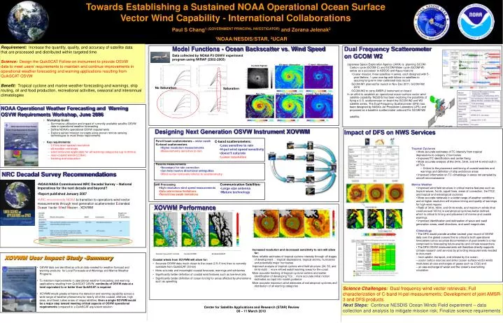
XOVWM User Impact Study -Summary • OSVW data are identified as critical data needed for weather forecast and warning products for Local Forecasts and Warnings and Marine Weather Programs • To maintain improvements in operational weather forecasting and warning applications resulting from QuikSCAT OSVW, continuity of OSVW data at a level equivalent to or better than QuikSCAT is required • XOVWM would greatly enhance the detection and warning capability across a wide range of weather phenomena for nearly all of the coastal, offshore, high seas, and Great Lakes areas of responsibilities. Even a single XOVWM would be a major step toward meeting critical aspects of OSVW operational requirements compared to a QuikSCAT-equivalent solution Towards Establishing a Sustained NOAA Operational Ocean Surface Vector Wind Capability - International Collaborations Paul S Chang1 (GOVERNMENT PRINCIPAL INVESTIGATOR) and Zorana Jelenak2 1NOAA/NESDIS/STAR, 2UCAR Model Functions - Ocean Backscatter vs. Wind Speed Requirement: Increase the quantity, quality, and accuracy of satellite data that are processed and distributed within targeted time Science:Design the QuikSCAT Follow-on instrument to provide OSVW data to meet users’ requirements to maintain and continue improvements in operational weather forecasting and warning applications resulting from QuikSCAT OSVW Benefit: Tropical cyclone and marine weather forecasting and warnings, ship routing, oil and food production, recreational activities, seasonal and interannual climatologies Dual Frequency Scatterometer on GCOM W2 Data collected by NOAA P3 OSWV experiment program using IWRAP (2002-2005) • Japanese Space Exploration Agency (JAXA) is planning GCOM-Carbon cycle (GCOM-C) and GCOM-Water cycle (GCOM-W) series as a successor to ADEOS and Aqua missions • 13-year mission; three satellites in series, each designed with 5-year lifetime, 1-year overlap with follow-on satellites to assuring long-term inter-calibrated data record • GCOM-W1 planned for launch in Nov-Dec 2011, GCOM-W2 2016 • GCOM-W2 to carry AMSR-2 instrument on board • In an effort to establish an operational ocean surface vector wind satellite capability, NESDIS has been exploring the possibility of flying a U.S. scatterometer on board the GCOM W2 and W3 satellite series. The Dual Frequency Scatterometer (DFS) has been designed by NASA’s Jet Propulsion Laboratory (JPL) and proposed as a baseline scatterometer onboard the GCOM-W2 satellite. C band - Attenuation KU band - Attenuation Ku-band Sigma0 No Saturation Saturation Rain Rate C band - Rain Backscatter KU band - Rain Backscatter NOAA Operational Weather Forecasting and Warning OSVW Requirements Workshop, June 2006 • Workshop Goals: • Summarize utilization and impact of currently available satellite OSVW data in operational weather forecasting • Define NOAA’s operational OSVW requirements • Explore sensor/mission concepts using proven remote sensing technologies to meet these requirements • Key requirements: • 2.5 km level spatial resolution • all weather retrievals • wind retrievals applicable for all warning categories (up to 80m/s) • near-coastal winds (2.5km) • training and education Designing Next Generation OSVW Instrument XOVWM Impact of DFS on NWS Services • Pencil beam scatterometers –wider swath • Ku-band scatterometers • Higher resolution measurements • Measurements sensitive to rain • Passive measurements • Necessary for rain correction • Can help resolve directional ambiguities • Wind vector retrievals inferior to scatterometry • C-band scatterometers: • Less sensitive to rain • H-pol wind speed sensitivity • doesn’t saturate • Lower resolution • Tropical Cyclones • • More accurate estimates of TC intensity from tropical depressions to category 2 hurricanes • • Improved TC identification and center fixing • • More accurate analysis of the 34-kt, 50-kt, and 64-kt wind radii in all TCs • – Critical to the placement and timing of coastal watches and warnings and definition of ship avoidance areas • • Improved information on TC climatology in areas not sampled by aircraft reconnaissance • Marine Weather • • Improved wind field structure in critical marine features such as tropical waves, fronts, squall lines, areas of convection, the ITCZ, and tropical and extratropical cyclones • • More accurate retrievals in a wider range of weather conditions and at higher resolution will improve timing and quality of warnings for high-wind regions • • Radii of 34-kt, 48-kt, and 64-kt winds, and maximum winds (that could exceed 100 kt) in extratropical cyclones better defined, which is critical to timing and placement of marine and coastal warnings • • Improved identification and delineation of wave and swell generation areas, swell directions, and swell magnitudes • Climatology • • The DFS would provide another several-year record of OSVW data over the global oceans that is critical to both operational forecasters (since accurate documentation of past events is a key component to forecasting future events) and climate researchers • • The DFS OSVW measurements will therefore directly supports climate research and services by providing measurements needed to document: • – heat uptake, transport, and release by the ocean; • – ocean carbon sources and sinks (ocean surface vector winds modulates air-sea exchanges of gases such as CO2) and • – air-sea exchange of water and the ocean’s overturning circulation NRC Decadal Survey Recommendations • NOAA/NASA Commissioned NRC Decadal Survey – National Imperatives for the next decade and beyond? • Report published January 2007 • NRC recommends NOAA to transition to operations wind vector measurements through next generation scatterometer Extended Ocean Vector Wind Mission - XOVWM • Communication Satellites: • Large size antenna • Mature technology • SAR Processing • High resolution wind speed measurements • Data rate/volume limitations • Revisit time/swath limitations XOVWM Performance Increased resolution and decreased sensitivity to rain will allow for: More reliable estimates of tropical cyclone intensity through all stages of development tropical depressions, tropical storms, hurricanes and potentially major hurricanes Improved analysis of tropical cyclone wind field structure (34, 50, and 64 kt radii) more refined watch/warning areas for the coast More accurate tracking of tropical cyclone centers and earlier identification of developing TCs more accurate initial motion estimates as input into model guidance More accurate maximum wind estimates of extratropical cyclones and distribution of all warning categories Simulated “ground truth” wind field Simulated XOVWM Simulated QuikSCAT Coastal winds from XOVWM will allow for: • Accurate OSVW data much closer to the coast (2.5–5 km) than is currently available from QuikSCAT (30 km) • More accurate and meaningful coastal forecasts, warnings and advisories • Significantly better definition of coastal wind features such as low-level jets • Significantly better definition of ocean forcing for areas affected by phenomena such as upwelling Science Challenges:Dual frequency wind vector retrievals; Full characterization of C-band H-pol measurements; Development of joint AMSR-3 and DFS products Next Steps:Continue NESDIS Ocean Winds Field experiment – data collection and analysis to mitigate mission risk; Finalize science requirements