Download
1 / 10
100 likes | 184 Views
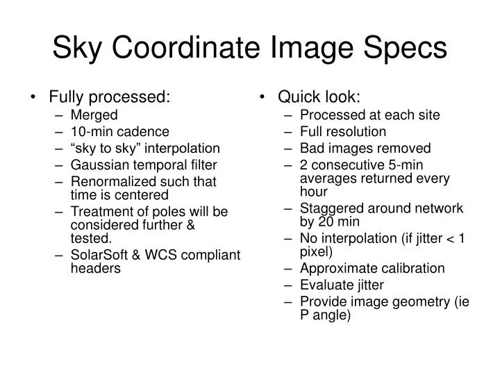
Fully processed: Merged 10-min cadence “sky to sky” interpolation Gaussian temporal filter Renormalized such that time is centered Treatment of poles will be considered further & tested. SolarSoft & WCS compliant headers. Quick look: Processed at each site Full resolution

E N D
Fully processed: Merged 10-min cadence “sky to sky” interpolation Gaussian temporal filter Renormalized such that time is centered Treatment of poles will be considered further & tested. SolarSoft & WCS compliant headers Quick look: Processed at each site Full resolution Bad images removed 2 consecutive 5-min averages returned every hour Staggered around network by 20 min No interpolation (if jitter < 1 pixel) Approximate calibration Evaluate jitter Provide image geometry (ie P angle) Sky Coordinate Image Specs
Remapped images • Full Reduction • Single-site @ 1 min • Merged @ 10 min • Temporal filter same as sky coord images • Spatial resolution to match disk center in longitude & sin lat • Specify heliocentric coordinates with a constant gird, not heliographic (see next slide) • For 10-min average, no need to correct for differential rotation • Space pixel coordinate definition consistent with temporal definition • Include specification of CR Time in header • Quick look • Produced from quick-look sky images
Definition of heliocentric coordinates • 0,0 is at central meridian, solar equator • Longitude coordinate is angular distance from central meridian • Sin latitude coordinate is measured from equator
Full processing: Merged, uniform noise level Need differential rotation correction Create usual synoptic map (once every CR) w. cos4 weights, 1-degree resolution Create high-res synoptic map, once per CR, narrow weights, match disk center resolution (or use 0.2 degrees, will test) Create “Best” global map: Cadence: 1 hr goal, 4 hr requirement Spatial resolution: matched to disk center, Spatial weighting function is broad, ± 60°, temporal weighting is narrow Consider creation on demand Do not match SOLIS cadence, try for compatible data format Location of missing data should be identified Fill poles like SOLIS Treat LOS projection like SOLIS Quick look: Spatial resolution: 1 degree 1-hr (goal) or 4-hr cadence updated map Constructed from quick-look sky images Leave hook to include flux transport for backside fields, but don’t include for now. Synoptic maps
Synoptic map defintions • Usual synoptic map: covers 1 Carrington rotation, contains all central meridian data available, created once per CR. • Best global map: created frequently, includes data obtained after target time of map. • Updated map: like Best global map, but contains only data prior to target time.
Data distribution • Maintain access to on-line quick-look jpegs • Movies • Separate web page for magnetograms • Calendar & clock graphical search tools
Older data • Make available jpegs of either on-demand or all single site sky images, registered & centered, no ZPC • How much jpeg compression is acceptable? Jpeg2000? • Evaluate cost of applying current ZPC, either on demand, or for entire set. Estimate time required for processing & development. • Work with Yan Li to test ZPC for LCT • Consider constructing a registered merged ZPC’ed movie for a SHINE interval • Make data limitations clear on the web page, perhaps in header
Cross-site sensitivity: Use Harry’s code to see how big the problem is Characterize temporal & site-dependent behavior Perhaps use global optimization to remove relative variation in network Absolute reference from external source Spherical Harmonics: Yes, on synoptic maps Adopt Wilcox normalization Max degree 50 Potential Field Extrapolation: Provide “hairy ball” pictures Provide links to other sources of results Provide data to groups with existing code (e.g. CCMC) Additional Processing
Additional processing II • Destretching: • Test effectiveness & cost of correcting RCP & LCP distortion • Consider adapting Lockheed code, or Harry’s code. • Restoration: • Lower priority • Might be useful to smooth noise variations
Zero Point Correction • Destretch RCP + LCP of reference magnetograph • Characterize new modulator response • Apply existing ZPC to new data, evaluate results.