Download
1 / 26
260 likes | 377 Views
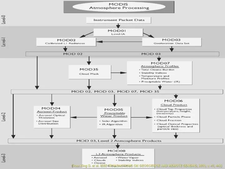
( from King D. et al. IEEE TRANSACTIONS ON GEOSCIENCE AND REMOTE SENSING, 2003, v. 41, 442). Продукты MODIS (Level 2, атмосфера). ( from King D. et al. IEEE TRANSACTIONS ON GEOSCIENCE AND REMOTE SENSING, 2003, v. 41, 442). Продукты MOD 06.

E N D
(from King D. et al. IEEE TRANSACTIONS ON GEOSCIENCE AND REMOTE SENSING, 2003, v. 41, 442)
Продукты MODIS (Level 2, атмосфера) (from King D. et al. IEEE TRANSACTIONS ON GEOSCIENCE AND REMOTE SENSING, 2003, v. 41, 442)
Продукты MOD06 (from King D. et al. IEEE TRANSACTIONS ON GEOSCIENCE AND REMOTE SENSING, 2003, v. 41, 442)
Изображение Алтайского края по данным ASTER/Terra
Графическое изображение технологии измерений MISR/Terra (from Martonchik J. et al. IEEE TRANSACTIONS ON GEOSCIENCE AND REMOTE SENSING, 1998, v.38, 1212)
CERES data flow diagram. Boxes represent input or output archived data products. Circles represent algorithm processes
Aqua: Earth-Observing Satellite MODIS the ModerateResolution Imaging Spectroradiometer AMSR-E the Advanced Microwave Scanning Radiometer for EOS AMSU-A1 TheAdvanced Microwave Sounding Unit AMSU-A2 AIRS the Atmospheric Infrared Sounder HSB the HumiditySounder for Brazil CERES Cloudsand the Earth’s RadiantEnergy System
Схематическое изображение диапазона длин волн (частот), покрываемого радиометрами спутника Aqua AMSU-A R = 40,5 км AIRS/HSB R = 13,5
Погрешности восстановлений профилей температуры и влажности с использованием данных AIRS/HSB/AMSU Comparison of regression retrieval temperature rms errors from AIRSand ATOVS Comparison of retrieval water vapor rms percent error from AIRS andATOVS (from Goldberg M. et al. IEEE TRANSACTIONS ON GEOSCIENCE AND REMOTE SENSING, 2003, v.41, 379)
Погрешность восстановления температурного профиля с использованием AIRS/HSB/AMSU при наличии облачного покрова в поле зрения приборов (from Goldberg M. et al. IEEE TRANSACTIONS ON GEOSCIENCE AND REMOTE SENSING, 2003, v.41, 379)
Погрешность восстановления температурного профиля с использованием AIRS/HSB/AMSU при наличии облачного покрова в поле зрения приборов (from Goldberg M. et al. IEEE TRANSACTIONS ON GEOSCIENCE AND REMOTE SENSING, 2003, v.41, 379)
• AIRS/AMSU/HSB data products are available from the Goddard Space Flight Center DAAC at http://daac.gsfc.nasa.gov. • CERES data products are available from the Langley Research Center DAAC at http://eosweb.larc.nasa.gov. • MODIS ocean and atmosphere data products are available from the Goddard Space Flight Center DAAC at http://daac.gsfc.nasa.gov. • MODIS land data products are available from the Earth Resources Observation System (EROS) Data Center DAAC at http://edcwww.cr.usgs.gov/landdaac. • MODIS snow and ice data products are available from the National Snow and Ice Data Center DAAC at http://wwwnsidc. colorado.edu. • AMSR-E data products are available from the National Snowand Ice Data CenterDAAC at http://www-nsidc.colorado. edu.
Состав аппаратуры Aura/EOS • HIRDLS (High Resolutions Dynamics Limb Sounder) • MLS (Microwave Limb Sounder) • OMI (Ozone Monitoring Instrument) • TES (Tropospheric Emission Spectrometer)
Характеристики, измеряемые приборами Aura Algorithm Theoretical Basis Document (ATBD) available on the EOS Project Science Officehome page:http://eospso.gsfc.nasa.gov/eos_homepage/for_scientists/atbd/index.php (look underMLS, TES, HIRDLS and OMI).
4.Программы NPOESS (National Polar-orbiting Operational Environmental Satellite System) и NPP (Npoess Preparatory Project) Авторы проекта: Department of Commerce`s National Oceanic and Atmospheric Administration (NOAA) (US) Department of Defense (US) National Aeronautics and Space Administration (NASA)
Составаппаратуры NPOESS (National Polar-orbiting Operational Environmental Satellite System) • VIIRS — Visible/Infrared Imager Radiometer Suite • CrIS — Cross-track Infrared Sounder • CMIS — Conical-scanning Microwave Imager Sounder • OMPS — Ozone Mapping and Profiler Suite • GPSOS — Global Positioning System Occultation Sensor • SESS — Space Environment Sensor Suite • Aerosol Polarometer • ATMS — Advanced Tecnology Microwave Sounder • CERES — Cloud and Earth`s Radiant Energy System • TSIM — Total Solar Irradiance Sensor • ALT — Radar Altimeter • SARSAT — Search and Rescue Satellite Aided Tracking System • DCS — ARGOS/Data Collection System
5. Программа RADARSAT-1 www.rsi.ca
Пример цифрового изображения RADARSAT-1 www.scanex.ru
6. Индийская космическая программа IRS
Пример цифрового изображения IRS (PAN) www.scanex.ru
7. Программа IKONOS (from Dial G. et al. Rem. Sensing Envir., 2003, v.82, 23)
Relationship between IKONOS revisit intervals, latitude, sensor elevation angles, and GSD (from Dial G. et al. Rem. Sensing Envir., 2003, v.82, 23)
Пример изображения IKONOS (from Dial G. et al. Rem. Sensing Envir., 2003, v.82, 23)