Download
1 / 22
220 likes | 355 Views
Design of a Mobile Sensor Platform and Localization. Overview. Motivation and System Requirements Drive System and H-Bridge Sensing capabilities Processing capabilities System Facts Platform Improvements Introduction to Localization Methods Localization using ARToolkit. Motivation.

E N D
Design of a Mobile Sensor Platform and Localization
Overview • Motivation and System Requirements • Drive System and H-Bridge • Sensing capabilities • Processing capabilities • System Facts • Platform Improvements • Introduction to Localization Methods • Localization using ARToolkit
Motivation • The goal of this project is to construct a mobile autonomous sensor paltform which is able to “sense” the environment and act upon it through both local decision making as well as collaboration among networked mobile sensor platforms
System Requirements • System must be small in size for portability • It must be low cost for large volume platform deployment • Tether-free outdoor deployment • Energy-efficient for longer battery life • On-board processing capability for autonomous local decision making
Drive System • The drive system uses two gearhead motors attached on either side at the back of the mobile sensor platform • The motors can be driven with up to 12VDC. However, to limit the speed of the mobile sensor platform only 5VDC is used • The platform uses an omni-directional third wheel to allow for differential steering
H-Bridge • The H-Bridge is used to control the motors • Separate inputs for logic and motor power • Enable/Disable Input • Four data inputs • Four motor outputs (2 per motor)
Controlling the H-Bridge • The H-Bridge is controlled with the parallel port on the computer • Pulse width modulation is used to control the speed of the platform as it moves along • The H-Bridge can be enabled/disabled to conserve power and to prevent overheating
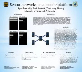
Sensing • The mobile platform is currently equipped with two kinds of sensors • Imaging sensor • Range sensor
Imaging Sensor • The imaging sensor is a Logitech Quickcam Pro 4000, used for target recognition through advanced image processing. It is able to take pictures at a resolution of up to 1.3 megapixels, with a default setting at 640x480pixels.
Range Sensor • The range sensor works by transmitting a pulse of sound outside the range of human hearing. The sound reflects back to the ranger from any object in the path of its sonic wave. The distance of the object is obtained by measuring the time it takes for the sonic wave to bouce back. The range sensor has an approximate beam pattern that is 60 in width, and less than 10 feet deep.
Processing • The mobile sensor platform uses a Mini-ITX (7x7in) form factor motherboard, the VIA EPIA-M10000 • The board has a 1Ghz processor, room for one memory module, integrated video, audio, ethernet, and one PCI expansion slot (used for wireless) • It is excellent for this application because it is powerful, yetvery compact
System Facts • Dimension 12x15.5x10 inches • Cost: Less than $600 • Battery Life: 3hours with moderate use • Voltage regulator shuts down itself when overheated • Fast processor & 512MB of memory • Switches allow to toggle between internal (battery) and external power • Software: Latest version of Fedora Core andopen source drivers
Platform Improvements • Place additional range sensors along the sides and the back of the mobile platform as the current design only allows it to detect objects directly in front of it. • Reduce the weight of the platform by replacing the heavy, although low-cost, sealed lead acid (SLA) battery. One option is the much lighter Li-Ion battery, which maintains a flatter discharge curve than other kinds of batteries. However, this option is far more expensive.
Research Highlights • Self-deploying sensor networks for robust reconnaissance and surveillance • Self-organizing sensor networks for adaptive target tracking • Distributed coordination with or without communication • The mobile platforms will orient themselves and collaboratively achieve complex tasks like tracking of moving targets, target identification,multiple target detection, etc.
Localization • It is necessary for the mobile sensor platforms to be able to determine where they are located • Localization can be relative: A robot knows where it is located relative to another robot • Localization can be absolute: A robot knows where it is located in reference to the building it is in • Ideally each platform would be aware of both its absolute position, and its position relative to other mobile sensors
Localization Methods • Global Positioning System (GPS) • Laser Tracking • Sonar • Radio – UT wireless network (triangulation) • Visual markers
Localization Using Visual Markers • There are several different ways of using visual markers for localization: • Use a color coded cylinder mounted on top of each mobile sensor platform to allow them to identify each other. This method provides only identification and relative location. Distance and exact location are difficult to derive. • Use pattern recognition to identify patterns attached to platforms or landmarks. Based on the pattern the orientation, distance, and angle can be determined.
Localization Using Pattern Recognition • There is open-source software which is widely used to create Augmented Reality (AR) applications • The ARToolkit is able to localize targets in live video without any noticeable delay • The first step is to threshold the image, then it detects where there is a square marker • Once the marker is found, it calculates the distance, position and orientation
Using the ARToolkit • The software detects the marker and displays the coordinate system on top of it using OpenGL • The coordinates can be used to determine where the platform is located
Using the ARToolkit • In this example the software actually super-imposes a 3D cube on the live video