Download
1 / 18
180 likes | 185 Views
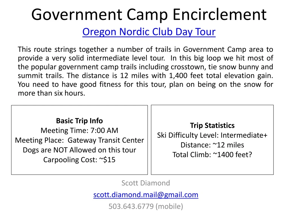
Explore a variety of trails in the Government Camp area on this intermediate level day tour. The 12-mile loop includes popular trails like Crosstown, Tie Snow Bunny, and Summit. Good fitness is required as the tour lasts more than six hours.

E N D
This route strings together a number of trails in Government Camp area to provide a very solid intermediate level tour. In this big loop we hit most of the popular government camp trails including crosstown, tie snow bunny and summit trails. The distance is 12 miles with 1,400 feet total elevation gain. You need to have good fitness for this tour, plan on being on the snow for more than six hours. Government Camp EncirclementOregon Nordic Club Day Tour Trip StatisticsSki Difficulty Level: Intermediate+ Distance: ~12 milesTotal Climb: ~1400 feet? Basic Trip InfoMeeting Time: 7:00 AMMeeting Place: Gateway Transit CenterDogs are NOT Allowed on this tourCarpooling Cost: ~$15 Scott Diamond scott.diamond.mail@gmail.com 503.643.6779 (mobile)
Cancellation • Cancellations are rare but they do occasionally happen • Please check your e-mail before driving out to carpool spot. • I’ll e-mail only if there is a cancel or change in plans, otherwise the trip is on.
Estimated Timing • 7:00 AM Departure from Gateway • Bathroom stop on the way • 9:00 AM Start Skiing from Glacier view Snow Park • Glacier View is across street from entrance to Ski Bowl (yes there really is a sno park there) • 12:00 PM Trillium Lake trailhead • 3:00 PM Finish Skiing • 4:30 PM back at Gateway Note that if you need to rent skis you’ll need to rent them prior to the trip. It takes quite a while to rent and it doesn’t work to split the group and try and regroup when renting on the way
Difficulty Rating Scale 5 5 5 4 4 4 3 3 3 2 2 2 1 1 1 0 0 0 Technical Skiing Ability Skiing Fitness Isolation/Risk
Appropriate Skis for this Tour The following types of skis, listed in green, should be suitable for this tour. Please see ONC Ski Gear webpage for more information on equipment. • Skate Ski • Competitive Cross Country/Track Ski • Light touring ski • Backcountry Ski (typically metal edged) • Telemark Ski • AT (Advanced Touring) or Randonee Ski The above recommendations depend on the skill of the skier. Please contact me if you have questions.
S F
Estimated Ski Timing 0:00 Start Skiing Sno Park (3600 ft) 1:45 Junction Westleg 2:00 Junction Tie (4600 ft) 2:30 Cross Timberline Road 3:15 Snow Bunny (cross HWY 26) 3:30 Trillium Junction (3600 ft) (extended lunch) 4:45 Government Camp Sno Park (3950 feet) 5:15 Ski Bowl East 5:45 Back at Start
More Detailed Route Info Distance 12 miles This is a solid intermediate ski. There is a fair amount of climbing, a mix of road and trail skiing, and a lot of distance to cover. Conceptually the tour is split into three parts • We start out a Glacier View sno-park at 3,600 feet elevation and get on the Cross Town trail. This trail is single track and somewhat more technically difficult. We climb steadily to the Camp Creek trail (#754). Best case it will take us 1.5 hours to get to this intersection. From there we head up hill to Westleg and then up West Leg even more to the tie trail. This is the high point. We’ve climbed ~1,000 feet to 4,600 and we’ve done the hardest part of this tour. You will feel tired. • The next section is a lot more fun as we drop the 1,000 feet we gained. We drop down the Tie trail, cross Timberline road, drop down the snow bunny trail and cross HWY 26 to the Trillium Lake Sno-Park. Best case we’ll be there in 2:45 hours from start. But we continue dropping down steeper trail towards Trillium Lake. We have lunch here at a meadow at 3,600 feet. • At this point the “trail” is a road. We do need to climb 400 feet as we make our way up to Mazama snow park (4,000 feet) but it is scenic, the trail is well groomed and we make good speed. At Mazama the climbing is done. We head on Hemlock trail and cut through Ski Bowl on some nice fast roads. For fun we can even drop down the last couple hundred feet of the main run at Ski Bowl for our finish. I’ve done this tour twice. One time we zipped through in 4:45 hours and another time (breaking trail in horrible conditions) it took us almost 8 hours.
Topographic Map and GPS Track(you are not required to bring a GPS but I’m making this available) • GPS Track on CalTopo • The link above allows you to easily print a map of our route Sample map from CalTopo
Other Map Links • http://www.fs.usda.gov/Internet/FSE_DOCUMENTS/stelprdb5359669.pdf • http://www.fs.usda.gov/Internet/FSE_DOCUMENTS/stelprdb5396765.pdf
ONC Carpooling Policy If we don’t have drivers, we don’t have a trip. If you have a snow compatible car then please offer to drive. If we don’t have enough drivers then we’ll do a lottery to see who goes. For passengers, the ONC policy is each passenger contributes 15 cents per mile. For three or more passengers, the maximum total contribution by all passengers is limited to 45 cents per mile. A typical round trip distance to Mt Hood and back is 120 miles to 160 miles = $18-$24/person
ONC Ski Rating • Novice level • These tours are for the inexperienced skiers. While this is not a lesson, the leader will help new skiers as much as possible. Tour length is 3-5 miles over nearly flat terrain. • Beginning/Easy level • 4 to 6 Miles over gentle terrain at a pace comfortable for all participants • Intermediate level • 6 to 12 miles. Terrain flat to long hills that are no steeper than found on a road (maximum 10 degrees). Moderate pace. Trail turning skills required, if there are hills. • Advanced level • > 12 miles. Terrain flat to steep hills (> 10 degrees). Moderate to fast pace. Strong turning skills required on the tours with steeper slopes.
What to Bring/Gear(click links below for more info) • Ski Rental Options • What to Wear • Tour Essentials • Chocolate for trip leader! Note that if you need to rent skis you’ll need to rent them prior to the trip. It takes quite a while to rent and it doesn’t work to split the group and try and regroup when renting on the way
Electronic Map/GPS • Forget paper maps! • I’ve given up carrying paper maps and instead use my smartphone to see the track and where I am. This works really well. • Numerous smartphone GPS apps are available, my own favorite is Gaia ($10/year). • Additionally you can view/download full ONC track data set at CalTopo ONC Database See me at one of the club meetings if you need some help using this. I’ll assist for the cost of a pint! Sample screen shot for Gaia iPhone Software
Maps and Guidebooks are great for studying trip options at home. Note - There are always new trails being developed and the maps I have included in this packet may not be the most recent. If you want to buy your own maps for this trip then the best one I’ve found for Mt. Hood is the 2015 Mt. Hood Winter Trails (BuyBetterMaps, Amazon or your local REI) The best overall reference books is still Klindt Vielbig’s. This is out of print but you can still find used copies on Amazon Maps/Guides
Weather Reports Obviously the tour gets cancelled if we don’t have enough snow. Additionally if it looks like it is just going to rain on us all day then we’ll cancel. I like to use the following site to check the weather. • National Weather Service Zone Forecast. Good general description and snow level info. • Mount Hood WebCams. Amar Andalkar does a great job at pulling together all the WebCams. For day tours I like to look to see how much snow there is in Government Camp • Northwest Avalanche Center – Not applicable to the vast majority of ONC tours (since we rarely ski on or across slopes steep enough to avalanche)