Download

1 / 36
410 likes | 589 Views
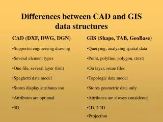
GIS Data Structures. How do we represent the world in a GIS database?. Basic Data Structures for GIS. 1. Vector. 2. Raster. 3. TIN (triangulated irregular network). 4. Tabular Information (attribute table). Vector Data Structure. polygons. lines. Vector Data Structure.

E N D
GIS Data Structures How do we represent the world in a GIS database?
Basic Data Structures for GIS 1. Vector 2. Raster 3. TIN (triangulated irregular network) 4. Tabular Information (attribute table)
Vector Data Structure polygons lines
Vector Data Structure In vector data layers, the feature layer is linked to an attribute table. Every individual feature corresponds to one record (row) in the attribute table.
About Image Files • Image files contain no data • They are the background • You can create data based on images • Not considered a “data” structure
Raster Data Structure A raster grid can store values that represent categories, for example, vegetation type The basic grid attribute table has a value and count field The value field has a code or some real number representing information about the grid cell. In this case it is a code for vegetation. The count field shows how many grid cells have that same value.
Raster Data Structure A raster grid can store values that represent categories, for example, vegetation type A grid table can also have additional information, in this case the name of the vegetation type. But is always has the value and count fields.
Raster Data Structure Grids can also store continuous values like elevation
Raster Data Structure Elevation grid for area north of Kirkuk, Iraq From space shuttle radar topography mission (SRTM) Zoom in and you see the grid cells These are called: Digital Elevation Models (DEM)
Raster Data Structure So 2 ways of representing elevation: Vector contour lines Raster grid
Raster Data Structure Sources of raster data Interpreted satellite imagery, e.g., land cover Conversion of vector to raster data
Raster Data Structure Spatial analysis performed on vector data Sources of raster data A density grid derived from the same crime data – interpolation of point data over a continuous surface A point layer of crime reports
Raster Data Structure Sources of raster data Although an digital aerial photo is in raster format, it has no data.
Raster and Vector Data Structures Raster data are described by a cell grid, one value per cell Vector Raster Point Line Zone of cells Polygon
Features with discrete shapes and boundaries (e.g., street, land ownership parcel, well) Database management Database query and reporting Network analysis High quality maps Continuous surfaces with fuzzy boundaries or with qualities that change gradual over space (e.g., soil, land cover, vegetation, pollution) Spatial analysis and modeling (e.g., agricultural suitability) Vector Raster
TIN Data Structure A 3rd data structure for representing surfaces: Triangulated Irregular Network (TIN)
TIN Data Structure Elevation points connected by lines to form polygons that contain topographic information
TIN Data Structure Elevation points connected by lines to form polygons that contain topographic information
Attribute Data Structure Attribute table “Flat File” with columns and rows Row = geographic feature record Column = attribute field (item of information about a feature)
Attribute field general types • Numeric (integer or decimals) • Text (string) • Date • Blob (binary large object)
Topology When you edit features in an electric utility system, you want to be sure that the ends of primary and secondary lines connect exactly and that you are able to perform tracing analysis on that electric network. Features need to be connected using specific rules.
Planar topology Property parcels of land must adjoin each other exactly, without gaps or overlaps. This two-dimensional graph is called a planar topology.
Topological relationships The relationships that do not change if you imagine a map being on a rubber sheet and you pull and stretch the rubber sheet in different directions. Vector and TIN data can have topological structure. Raster and images can not have a topological structure.
For your project • What data layers • Vector, raster, TIN, image? • Topological structure (network connectivity or planar topology)? • Attributes? • Minimum required accuracy?
Should a data layer be topologically structured? Some objects are non-topological and can be freely placed in a geographic area. Examples? Many objects are primarily stored in a GIS for the purpose of background display on a map, so it is usually not necessary to store them in a topological format. If roads are a background layer in your GIS, they will probably be simple features. If roads are part of an analysis of a transportation system, they should be topological features.
ArcGIS Major Data Formats • Shape files • Coverages (Arc/Info) • Geodatabases
Shape files Shape files can be created with ArcView software.
Arc/Info Coverages Coverages are an older data structure in which topology could be modeled. You will still find many data sets in Arc/Info coverage data formats. But for new data, you should use geodatabase formats.
Geodatabases Geodatabases can be created with ArcGIS 8.x and 9.x Geodatabases give you more power to specify rules for features and structure topology
Summary • 3 Spatial Data Structure Types in GIS • Vector • Raster • TIN • Attribute Data Structure – Tables of columns and rows • Topology – needed for spatial data to “know” where other data is