Download
1 / 15
310 likes | 647 Views
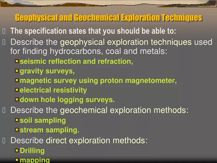
Geophysical and Geochemical Exploration Techniques. The specification sates that you should be able to: Describe the geophysical exploration techniques used for finding hydrocarbons, coal and metals: seismic reflection and refraction, gravity surveys,

E N D
Geophysical and Geochemical Exploration Techniques • The specification sates that you should be able to: • Describe the geophysical exploration techniques used for finding hydrocarbons, coal and metals: • seismic reflection and refraction, • gravity surveys, • magnetic survey using proton magnetometer, • electrical resistivity • down hole logging surveys. • Describe the geochemical exploration methods: • soil sampling • stream sampling. • Describe direct exploration methods: • Drilling • mapping
Seismic Reflection • This technique is used extensively in oil exploration as well as for metal ores. • Read pages 26 – 27 of the oil book. • Also look at page 289 of McLeish.
Seismic Reflection 2 • The seismic reflection method works by bouncing sound waves off boundaries between different types of rock. • The reflections recorded are plotted as dark lines on a seismic section.
Seismic Reflection 3 • This can be done on land or at sea. • It can show up oil traps and dipping beds. • It shows up rocks with contrasting densities so ores show up well as well as less dense rocks like salt.
Seismic Refraction • This is basically the same as seismic reflection but this time the waves are refracted through the layers before returning to the surface. • These waves hit the boundary between 2 rocks and then travel along the boundary before returning to the surface.
Gravity Surveys • These use a gravimeter that measure the gravity at a given point. • These can be carried in planes, ships or carried by hand. • If there are denser rocks below (ores) they will give a positive gravity anomaly. • If there are less dense rocks (salt/halite) there will be a negative anomaly.
Magnetic survey using a proton magnetometer • They are fast, provide a great deal of information for the cost and can provide information about the distribution of rocks occurring under thin layers of sedimentary rocks, useful when trying to locate orebodies • Aeromagnetic surveys are taken from a moving plane. • A magnetometer is the instrument used to measure the intensity of the magnetic field at a particular place.
Magnetic survey using a proton magnetometer 2 • The data for a survey can be plotted as a contour map using lines which join points of equal "magnetic" value. • From these maps geoscientists can locate magnetic bodies (even if they are not outcropping at the surface), interpret the nature of geological boundaries at depth, find faults etc.
Electrical conductivity (resistivity) can be measured by applying a current directly into the ground through a pair of electrodes. • A voltage difference measured across a second electrode pair provides the necessary information to calculate the apparent earth resistivity. • The depth of investigation depends on the electrode separation and geometry, with greater electrode separations yielding resistivity measurements to greater depths.
Down hole logging surveys. • In the oil industry many types of geophysical survey can be carried out by placing instruments down the exploration borehole. • See page 35 of the oil book. • Such things as: • Resistivity • Sound wave velocity • Gamma ray radiation • These give clues about: • Porosity and permeability • Dip of beds • Fluid pressures
Geochemical Exploration Methods • There are only really two: • Soil surveys/sampling • Water surveys/sampling • Soil surveys give an indication of the chemistry of the underlying rocks (that have been weathered). • If on a slope the rock will be further up slope from the soil.
Geochemical Exploration Methods 2 • With stream sampling the chemistry of the water will be influenced by the rock it flows over. • The concentration of an element will be highest just downstream from the ore. • The concentration will then decrease as the water gets diluted further downstream.
Direct exploration methods: • There are 2 main methods: • Drilling • Mapping Drilling • Drilling in an area is often the only way of being absolutely sure what is underground. • The geochemical and geophysical methods will give a clue. • Analysing the samples and noting the depths at which rocks occur can help decide whether an ore is worth mining.
Direct exploration methods 2 Mapping • If rocks are exposed at the surface then mapping them can give a clear indication of the geology not only on the surface but also underground. • You may be able to work out an underground cross section.
It is usual for a whole array of techniques to be used together in order to finally decide: • Where an ore or resource is. • How much there is. • The grade of the resource. • Any geological problems. • Whether it is worth exploiting.