Download
1 / 24
240 likes | 324 Views
CHRP SPATIAL SURVEYS OF DISSOLVED OXYGEN BROWN UNIVERSITY & NARRAGANSETT BAY ESTUARY PROGRAM. Instrument Package : Sea-Bird SBE 19 plus SEACAT Profiler Depth, Temperature, Salinity, DO, Density, Chlorophyll, Turbidity

E N D
CHRP SPATIAL SURVEYS OF DISSOLVED OXYGEN BROWN UNIVERSITY & NARRAGANSETT BAY ESTUARY PROGRAM
Instrument Package: Sea-Bird SBE 19 plus SEACAT Profiler Depth, Temperature, Salinity, DO, Density, Chlorophyll, Turbidity Water column profiles at about 60 stations in the Providence River, upper Bay, Greenwich Bay, and upper East and West Passages Sampling interval = 0.25 sec, Descent rate = 4-5 sec/m
Two Type of Water column structure at Conimicut Point 2001 cool, low salinity, shallow pychnocline 2002 warm, high salinity, deep pychnocline
Cross Channel Transect Providence River 2006
Cross Channel Transect Bullock Reach 2006
Cross Channel Transect Barrington Beach 2006
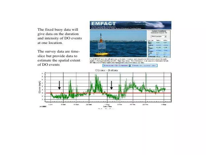
The spatial correlation of bottom DO at survey stations and with buoy DO data provide a methodology to estimate the spatial extent of low DO events within Narragansett Bay
Summary of the spatial extent of summer DO in Narragansett Bay Low DO events occur predominately in July and August with June and September transitional. Low DO events are episodic, often close to neap tides, and last from days to weeks. Low DO events cover much of the Providence River, the upper Bay, Greenwich Bay, and extend into the West Passage The spatial pattern of low DO is systematic and exhibits three coherent groups over much of the Bay. The correlation of bottom DO and buoy data can be used to estimate the spatial extent of low DO in Narragansett Bay.