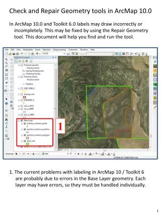
Download
1 / 24
240 likes | 250 Views
Data Alignment and Management in ArcMap. Lisa Stanners, Sean Jones. Agenda. Review tools available for improving spatial accuracy of your data Spatial adjustment & Rubber sheeting Snapping capabilities, tracing tools, auto-complete, etc. Alignment tools

E N D
Data Alignment and Management in ArcMap Lisa Stanners, Sean Jones
Agenda • Review tools available for improving spatial accuracy of your data • Spatial adjustment & Rubber sheeting • Snapping capabilities, tracing tools, auto-complete, etc. • Alignment tools • Review tools available to maintaining accuracy & coincidence • Map Topologies & Geodatabase Topologies Data Alignment and Management in ArcMap
Spatial Adjustment Projections • Shift data between coordinate systems Data Alignment and Management in ArcMap
Spatial Adjustment Transformations • Shift data in coordinate space • Digitize coordinates to real world • CAD coordinates to real world • Meters to Feet Data Alignment and Management in ArcMap
Spatial Adjustment Rubber Sheeting • Aligns local data • Integrating data from different scales and sources • Integrate 250K Hydro features into 50K data • Align national roads with local roads Data Alignment and Management in ArcMap
Spatial Adjustment Demo Data Alignment and Management in ArcMap
Summary of Adjustment Process Create Link Elements • Create Links • Set Adjust source • Set Adjustment Method • Preview • Adjust Set Adjustment Source Set Adjustment Method Preview Adjustment Adjust data Data Alignment and Management in ArcMap
Keeping Your Data Aligned • Know what the basic tools are and how to use them • Snapping environment • Basic snapping • “Classic” snapping • Snap to feature • Auto-Complete (polygon and freehand) • Trace construction tool • Extend and Trim tools • Auxiliary anchor (Rotate and Scale tools) Data Alignment and Management in ArcMap
Keeping Your Data Aligned • New tools introduced at 10.1 to help with this process: • Align To Shape – adjust layers to traced shape • Align Edge – snap edges together to close gaps Data Alignment and Management in ArcMap
Geoprocessing Alignment Tools • Snap – bulk snapping based on user specified rules • Edit session • Integrate Data Alignment and Management in ArcMap
Aligning DataDemo Data Alignment and Management in ArcMap
Move a pipe and its valves Soil polygons must not overlap Move a parcel boundary Error Find error Fix error First Main Main Main First First Topologies – Why would you want to use one? • Tools for editing coincident geometries between feature classes • Tools for finding and fixing errors based on rules you define Streets must not intersect Find error Fix error Main First Intersection error Data Alignment and Management in ArcMap
Topologies – What kinds are there? • Map Topologies (requires only Basic license) • Can be used with feature classes or shapefiles in same workspace • Saved in map document, not in the geodatabase • Geodatabase Topologies (requires Standard license) • Allows rules to be defined and errors found • Must be used with feature classes in same dataset • Persisted in the database, dirty areas created when features edited Data Alignment and Management in ArcMap
Topologies – Editing coincident geometries • Tools to select topology elements • Topology Edit Tool • Topology Edit Trace Tool • Tools to update topology elements • Modify Edge • Reshape Edge • Align Edge • Generalize Edge • Reconnect Nodes Data Alignment and Management in ArcMap
Topology Editing Tools Demo Data Alignment and Management in ArcMap
Geodatabase Topologies – Topology Rules • 32 topology rules • Single or multiple feature classes • Apply to feature class or subtype level • Categorized by geometry type (polygon, line, point) • Can also export topology errors with a Geoprocessing command • i.e Soil Polygons can’t have gaps between them Data Alignment and Management in ArcMap
Before After Clustering Cracking Geodatabase Topologies – Validating a Topology • Integrates geometries based on a cluster tolerance • Cracking –Vertices added at intersections of feature edges • Clustering – Snapping vertices that fall within cluster tolerance • Validates topology rules which may generate errors • Deletes errors if the rules are no longer violated • No new features are created Data Alignment and Management in ArcMap
Geodatabase Topologies – Error Inspector • Error Inspector lets you view and fix topology errors in a table. • The rule violated • The feature class or classes involved in the error • The geometry of the error • The feature ID of the features involved in the error • Whether or not the error has been marked as an exception Data Alignment and Management in ArcMap
Geodatabase Topologies – Editing Errors • Errors cannot be deleted directly, the features must be edited and the topology re-validated • Three options for correcting errors: • Leave the error in the database • Fix the error • Elevate the error to exception status. This allows you to say this rule applies everywhere except ‘here’ Data Alignment and Management in ArcMap
Geodatabase Topologies – Editing Errors • Select the topology errors on the map • Creates an “Active Error Selection” • Context menu with fixes based on rule • Revalidate after edits Data Alignment and Management in ArcMap
Topology ErrorsDemo Data Alignment and Management in ArcMap
Summary of Topologies • If you just need to edit coincident boundaries – consider a map topology • If you need to define and validate rules – use a geodatabase topology • With geodatabase topologies: • Build and validate to improve spatial integrity between your data layers • Use the available editor tools to find and fix your errors • Use automated fixes as much as you can, but they aren’t the answer for every error Data Alignment and Management in ArcMap
Thank you… Please fill out the session survey in your mobile app Click on this session in the agenda Click “Technical Workshop Survey” Answer a few short questions and enter any comments Paper – pick up and put in drop box Data Alignment and Management in ArcMap