Download

1 / 13
130 likes | 473 Views
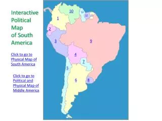
12. 13. Page 13. The Political Map of Colonial America. Lesson 3. Lesson 3: The Political Map of Colonial America. Knowledge Check. Without using any helps, label:. the 13 British colonies in America the four regions of British colonial America.

E N D
12 13
Page 13 The Political Map of Colonial America Lesson 3
Lesson 3: The Political Map of Colonial America Knowledge Check Without using any helps, label: • the 13 British colonies in America • the four regions of British colonial America
Lesson 3: The Political Map of Colonial America R 13 LEARNING TARGETS: • I can locate the 13 British colonies in America. • I can locate the four key British cities in America. • I can locate the four British colonial regions.
Lesson 3: The Political Map of Colonial America R 13 Attach the map of colonial America circa 1750.
Lesson 3 12 13 THE POLITICAL MAP OF COLONIAL AMERICA KNOWLEDGE CHECK NOT in your notebook – label the 13 colonies and 4 regions. OBJECTIVES: • Identify and locate the colonies of British colonial America. • Identify key cities of British colonial America. • Identify the four British colonial regions. 1 2 3
Lesson 3: The Political Map of Colonial America STEP 1: On the large map, color each colony: Connecticut Delaware Georgia Maryland Massachusetts New Hampshire New Jersey New York North Carolina Pennsylvania Rhode Island South Carolina Virginia Then label each colony. Add to your KEY. Use pages 86 and 118.
Lesson 3: The Political Map of Colonial America STEP 2: On the large map, locate the following Major British Cities: Boston, Massachusetts New York, New York Philadelphia, Pennsylvania Charleston, South Carolina Then label each city. Add to your KEY. Use pages 86 and 99 as resources.
Lesson 3: The Political Map of Colonial America STEP 3: Draw the boundaries of the four regions: Southern Colonies Middle Colonies New England Colonies Backcountry Then label each region. Add to your KEY. Use page 86 and 111 as resources.
Lesson 3: The Political Map of Colonial America REVIEW the MAP
Lesson 3: The Political Map of Colonial America 13 12 11 10 9 8 7 6 5 4 3 2 1 NEW ENGLAND COLONIES Connecticut – 1636 Rhode Island – 1636 Massachusetts – 1620 New Hampshire – 1623 MIDDLE COLONIES Delaware – 1638 Pennsylvania – 1682 New Jersey – 1630 New York – 1625 SOUTHERN COLONIES Georgia – 1732 South Carolina – 1663* North Carolina – 1663* Virginia – 1607 Maryland – 1634 * Carolinas split in 1729
Lesson 3: The Political Map of Colonial America 14 15 16 17 KEY CITIES Boston – Massachusetts New York – New York Philadelphia – Pennsylvania Charleston – South Carolina
Lesson 3: The Political Map of Colonial America BRITISH COLONIAL REGIONS New England Colonies C Middle Colonies B Backcountry D Southern Colonies A