Download
1 / 1
10 likes | 96 Views
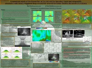
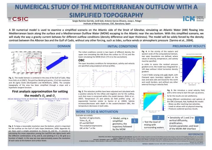
DOMAIN. First analysis approximation for setting the model’s Θ b and Θ s.

E N D
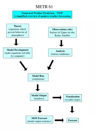
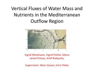
DOMAIN Firstanalysisapproximationforsettingthemodel’sΘbandΘs Fig. 1.The model domain is centered in the area of the Gulf of Cadis. Map from Peliz et al (2007).The grid has 96×64 grid points, 3.5×3 km resolution and 36 sigma levels (Shchepetkin and McWilliams, 2005). The complex topography of the area has been simplified through a slope and a hyperbolic tangent function. Fig. 3. To keep a reasonable resolution near the bottom, which is important for the outflow on the Gulf of Cadiz slope (Hedstrom, 2009; Appendix B), we have used a simple procedure to choose Θband Θs. It consists in calculating the mean separation among the last/first two sigma levels with the different combinations of Θb and Θsand plotting it in a 3D grid as a function of depth. In this way we may approximately assess the resolution of each value at the bottom and surface levels. Sergio Ramírez-Garrido, Jordi Solé, Antonio García-Olivares, Josep L. Pelegrí Institute of Marine Sciences, CSIC, Barcelona, Spain A 3D numerical model is used to examine a simplified scenario on the Atlantic side of the Strait of Gibraltar, simulating an Atlantic Water (AW) flowing into Mediterranean basin along the surface and a Mediterranean Outflow Water (MOW) escaping to the Atlantic near the sea bottom. With this simplified scenario, we will study the way a gravity current behaves for different outflow conditions (density difference and layer thickness). The model will be solely forced by the density contrast between the Alboran Sea and the Gulf of Cadiz, without any other forcing, such as tides, surface winds or atmospheric pressure [Sanino et al., 2004]. NUMERICAL STUDY OF THE MEDITERRANEAN OUTFLOW WITH A SIMPLIFIED TOPOGRAPHY INITIAL CONDITIONS PRELIMINARY RESULTS The initial conditions consist in two layers of different density, the upper one simulating the AW (from the surface to 175 m) and the lower simulating the MOW (from 175 m to the sea bottom). OBC The open boundary conditions for temperature, salinity and velocity are specified using analytical vertical profiles. Fig. 4. In the vicinity of the eastern and western ends of the computational domain, two open boundaries are defined, where values of velocity, temperature, and salinity must be specified. In order to assess the residual pressure gradient error, the model was integrated for 120 days without initial horizontal density gradient. T and Sfields varying only with depth, with Clamped open boundary applied on the east and west side and Closed for the north and south borders, and without any other external forcing or velocity field. Fig. 2. The velocities profiles have been adjusted and calculated with a positive velocity for the inflow and negative one for the outflow, such that mass is conserved within the model domain. (Pelizet al., 2007). Temperature (T) and salinity (S) field profiles using an exponential function similar to Sanino et al. (2004). Salinity increases/decreases with depth in the eastern/western OBC, the temperature decreases in both sides. Fig. 5. We introduce a zonal velocity field, with a time ramp to start the spin up process. So far the results are not satisfactory. Using different combinations and options at the OBC (Clamped, Rad, RadNud) the model: - Blows up after reaching max velocities, - Leads to values with no physical meaning, - Produces scattered spurious results. WORK TO DO & MOTIVATION Evaluate accurately: Number of sigma levels, Tcline, Θb ,Θs DT and NDTFAST The analytical expressions LBC at the *.in file REFERENCES AlvaroPeliz, JesusDubert, Patrick Marchesiello, Ana Teles-Machado.November 2007. Surface circulation in the Gulf of Cadiz:Model and mean flow structure. study Journal Of Geophysical Research, Vol. 112, C11015. Sannino, A. Bargagli, and V. Artale. May 2007. Numerical modeling of the semidiurnal tidal exchange through theStrait of Gibraltar. study Journal Of Geophysical Research, Vol. 117, No 0. Alexander F. Shchepetkin, James C. McWilliams. September 2004. The regional oceanic modeling system (ROMS): a split-explicit, free-surface, topography-following-coordinateoceanicmodel. OceanModeling, volume9, Issue 4 A. Sánchez-Román, G. Sannino, J. García-Lafuente, A. Carillo, and F. Criado-Aldeanueva.June 2009. Transport estimates at the western section of the Strait of Gibraltar: A combined experimental and numerical modeling study. Study. Journal Of Geophysical Research, Vol. 114, C06002, Katherine S. Hedström. November 2009. DRAFT Technical Manual for a Coupled Sea-Ice/Ocean CirculationModel (Version 3)