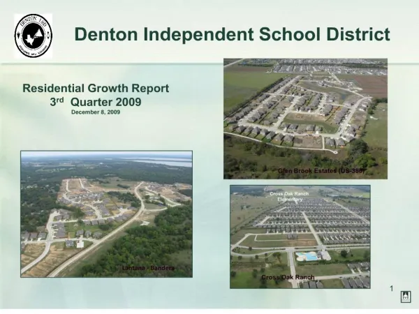
Download
1 / 26
260 likes | 372 Views
Future Range Mission Analysis Process (FRMAP) Information Brief 12 April 2005 CPT Scott M. Winter. Purpose. To provide an overview of the Future Range Mission Analysis Process (FRMAP) and provide the case study at Fort Bliss. Outline. Background FRMAP “Process” FRMAP Model

E N D
Future Range Mission Analysis Process (FRMAP) Information Brief 12 April 2005 CPT Scott M. Winter
Purpose To provide an overview of the Future Range Mission Analysis Process (FRMAP) and provide the case study at Fort Bliss.
Outline • Background • FRMAP “Process” • FRMAP Model • Fort Bliss Case Study • Environmental Working Group topics of discussion (Facts & Assumptions, Topics of Discussion, Conclusions) • Lessons Learned / The Way Ahead
Background What is the FRMAP? • A collective approach to range planning which strives to integrate expertise to arrive at optimal solutions for an Installation Range Complex Master Plan • Targets garrison staff and HQDA planners with subject matter expertise in range operations, range modernization, ITAM, environmental management and facilities management • The goal is to maximize the capability, availability, and accessibility of an installations ranges and training lands by minimizing external factors that restrict warfighters from training in realistic and sustainable conditions
Background • Received the mission from DAMO-TRS (Dec ’03) • Briefed the Feb ’04 PMR on the concept • Prepare to execute a pilot FRMAP at Fort Bliss • UA positioning announcement (Fort Bliss is gaining one UA) • Conducted two (2) reconnaissance missions (Aug & Oct) • Executed the FRMAP at Fort Bliss (Oct ’04)
FRMAP “Process” • Three phased approach: • Phase I – Develop, Plan, and Coordinate • Phase II – Execute FRMAP • Phase III – Prepare for Follow-on FRMAP’s
Team Ldr Facilities Logistics ITAM GIS Environment Range FRMAP “Process” Phase I – Develop, Plan, and Coordinate: • Build a core team • Develop a conceptual process model • Define the mission • Coordinate and build a FRMAP+ team • Collect information • RDP, EIS, INRMP, ICRMP, GIS layers, etc. • Coordinate with installation • Core team training and validation
FRMAP “Process” Phase II – Execute FRMAP: • Conduct reconnaissance • Issue a warning order • Synchronization matrix development • FRMAP+ team coordination meeting • FRMAP+ team and installation staff coordination • Plenary session and work groups breakout • Final Outbrief to the Garrison Commander • Alumni visit (tentative May ’05)
FRMAP “Process” Phase III – Follow-on FRMAP Mission: • Increased contract support • Decreased government participation • BRAC and IGPBS decisions made • Next possible locations (Benning and Carson)
FRMAP Model Goals and Objectives of the process: • Assist the installation in defining their Range Development Plan (RDP) as it changes with new mission requirements • Build logical courses of action for an Installation Range Complex Master Plan (RCMP) • Leverage existing tools and resources • Facilitate staff integration and coordination
Receipt of Mission MissionAnalysis Develop RCMP Develop COAs Approve COA Analyze COAs FRMAP Model Unconstrained& by Function Constrained& Combined
The Facilities Picture White Sands Missile Range Ranges Facilities Environment Range ITAM Ft. Bliss CantonmentArea Biggs AAF
The Environmental Picture Otera Mesa NR Restricted Areas- Unique Escarpment Vegetation /Aplomado Falcon Cultural Green Zones Need limited surveys OK to maneuver Facilities Environment Range ITAM CR Red Zones High density of Cultural sites No maneuver
The Range Picture Facilities Environment Range ITAM
The ITAM Picture Facilities Environment Range ITAM
The ITAM Picture Facilities Environment Range ITAM
The Collective Picture Facilities Environment Range ITAM
Environmental Working Group topics of discussion (Facts and Assumptions) • Less than 2% of Ft. Bliss training area is impacted by Environmental Issues • 17,000 known archaeological sites • McGregor Range land withdrawal agreement with BLM • T&E species include the Sneed Pincushion Cactus and the Aplomado Falcon • Vegetation threshold for dust and sedimentation estimated to be at 15% vegetation cover • Water supply problems to facilities not an issue at Ft. Bliss
Environmental Working Group topics of discussion (Topics of Discussion) • Directorate of the Environment (DOE) involvement is critical during range planning processes • Otera Mesa soils and vegetation not amenable to mounted off-road maneuvers • EIS authority should be started as early as possible and go to the lowest level necessary (IMA/MACOM level) • Programmatic meetings between state regulators, the advisory council and Bliss cultural representatives is imperative to determining thresholds for cultural site mitigation. (paleo-indian and pueblo sites)
Environmental Working Group topics of discussion (Topics of Discussion) • Heavy maneuver can take place in designated Green Cultural areas • Cost to survey cultural sites is roughly 35$ per acre • Maneuver boxes 4 and 7 will require cultural surveys. • Maneuver boxes 5 and 6 are not required to support a heavy BCT. Should be made accessible for dismounted training • Additional investigation should be done to look at conducting ADA training (on trail) and dismounted training on Otera Mesa
Environmental Working Group topics of discussion (Topics of Discussion) • Maneuver box 8, limited number of archaeological surveys have been done which will greatly increase costs to utilize it for heavy maneuver.
Environmental Working Group topics of discussion (Conclusions) • No environmental showstoppers for the Heavy UA • Otera Mesa should be reserved for ADA (on trail) and dismounted training • To complete NEPA documentation, a supplemental EIS to the Mission EIS should be completed with tiering off for each range project • Texas and New Mexico State Historic Preservation Offices (SHPO), the advisory council and Ft. Bliss cultural staff need to coordinate a programmatic agreement for cultural resource surveys, evaluation and mitigation
Lessons Learned • Integrated and shared information is critical to mission success • Ensure everyone understands and shares the vision • Spend more time during the recon to develop and assist the installation RDP • Use all Army tools and models (ARRM, ATTACC, RMTK) • The power of GIS – a picture tells a thousand words • Programmatic approach to cultural sites • Follow the environmental funding
The Way Ahead • DAMO-TRS is planning to use the SRP Contract to provide support pending FRMAPs • Fort Benning and Fort Carson are being considered for the next FRMAP • USAEC continues to refine and document the FRMAP
Questions??? Contact information: CPT Scott M. Winter Range Sustainment Branch U.S. Army Environmental Center 5179 Hoadley Road APG, MD 21010-5401 (410) 436-8761 Scott.Winter@aec.apgea.army.mil