1 / 12

Maps to Accompany Versailles Discussion

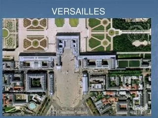
Maps to Accompany Versailles Discussion. Source : University of San Diego from website developed by Steve Schoenherr http://history.sandiego.edu/gen/text/versaillestreaty/vercontents.html. Europe 1914, from Life, 10/3/1938. Europe 1920, from Life, 10/3/1938.

moanna
Download Presentation

Maps to Accompany Versailles Discussion

An Image/Link below is provided (as is) to download presentation Download Policy: Content on the Website is provided to you AS IS for your information and personal use and may not be sold / licensed / shared on other websites without getting consent from its author. Content is provided to you AS IS for your information and personal use only. Download presentation by click this link. While downloading, if for some reason you are not able to download a presentation, the publisher may have deleted the file from their server. During download, if you can't get a presentation, the file might be deleted by the publisher.

E N D

Presentation Transcript


  1. Maps to Accompany Versailles Discussion Source: University of San Diego from website developed by Steve Schoenherr http://history.sandiego.edu/gen/text/versaillestreaty/vercontents.html

  2. Europe 1914,from Life, 10/3/1938

  3. Europe 1920,from Life, 10/3/1938

  4. Mandates in the Pacific 1919

  5. The Former German Telegraph Cables

  6. The Mideast After Sevres in 1920

  7. The Mandates in Arabia 1920

  8. Map of Woodrow Wilson’s US Tour in September 1919

More Related