Download
1 / 2
30 likes | 256 Views
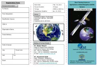
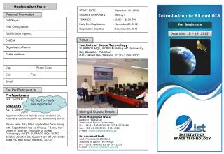
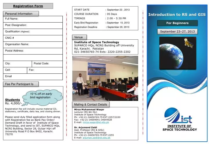
Registration Form. START DATE : September 23 , 2013 COURSE DURATION : 05 Days TIMINGS : 2:00 – 5:30 PM Early Bird Registration : September 10, 2013 Registration Deadline : September 20 , 2013. Personal Information.

E N D
Registration Form START DATE : September 23 , 2013 COURSE DURATION : 05 Days TIMINGS : 2:00 – 5:30 PM Early Bird Registration :September 10, 2013 Registration Deadline :September 20, 2013 Personal Information Introduction to RS and GIS For Beginners September 23–27, 2013 Venue Institute of Space Technology SUPARCO HQs, NCRG Building off University Rd, Karachi. Pakistan 021-34650765-74 Exts: 2220-2255-2202 Fee Per Participant Is Students Rs. 4,000/- Registration fee will include course material CD, stationery, certificate, daily tea, and closing dinner. Please send duly filled application form along with Registration fee as Bank Pay Order/ Demand Draft in favor of Institute of Space Technology, and send to IST, SUPARCO HQs, NCRG Building, Sector 28, GulzarHijri off University Road P.O Box 8402, Karachi. 75270 10 % off on early bird registration Mailing & Contact Details Mirza Muhammad Waqar Lecturer (RS &G ISc) Institute of Space Technology Ph: +92-21-34650765-79 EXT:2257/2220 Fax: +92-21-34694941-34644928 E-mail: mirza.waqar@ist.edu.pk Dr. ArjumandZaidi Asst. Professor (RS & GISc) Institute of Space Technology Ph: +92-21-34650765-79 EXT:2255 E-mail: arjuman.zaidi@ist.edu.pk INSTITUTE OF SPACE TECHNOLOGY
OBJECTIVE Recent advances in Geographical Information System (GIS) and Remote Sensing (RS) techniques and availability of satellite data at affordable cost have provided an opportunity to acquire the needful information in many application fields at spatial and temporal scales. Satellite data and GIS are being used in various fields of applications including, but not limited to, environmental studies, urban and regional planning, geology, agriculture, energy sector, natural disaster management, natural resources conservation, information technology, health sciences, and retail and marketing. The objective of this workshop is to impart knowledge about RS and GIS techniques to the beginners through lectures and hands on exercises using commonly used software. The workshop participants will be able to apply this knowledge in their specific fields. To develop an understanding of Geospatial Techniques using State-of-the-Art GIS and RS software • Getting to Know GIS (GIS Concepts, Vector and Raster data, Earth Model) • Introduction to Satellite Remote Sensing • Latest Developments in Remote Sensing • Hands-on Exercises using ArcGIS software • Displaying Data (Symbology and Labeling) • Map Projections, Coordinate Systems and Scale • Editing Data • Working with Tables (Tabular Data, Joins, Data Query) • Spatial Data Analysis (Geoprocessing in ArcMap: clip, intersect, union, buffer, etc.) • Presenting Data (Creating layouts) • Hands-on Exercises using ENVI, and ERDAS Imagine software • Digital Image Processing and Analysis On completion of the course, participants will receive a certificate of participation