Download

1 / 36
370 likes | 532 Views
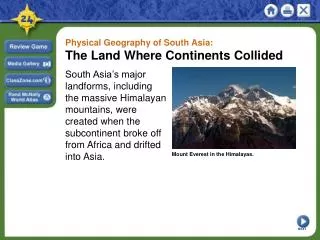
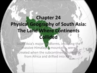
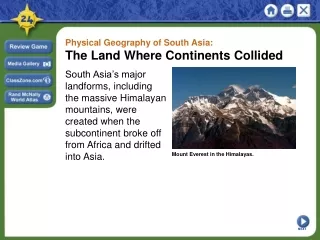
Physical Geography of South Asia: The Land Where Continents Collided. South Asia’s major landforms, including the massive Himalayan mountains, were created when the subcontinent broke off from Africa and drifted into Asia. Mount Everest in the Himalayas. NEXT. Section 1.

E N D
Physical Geography of South Asia: The Land Where Continents Collided South Asia’s major landforms, including the massive Himalayan mountains, were created when the subcontinent broke off from Africa and drifted into Asia. Mount Everest in the Himalayas. NEXT
Section 1 Landforms and Resources • South Asia is a subcontinent of peninsulas bordered by mountains and oceans. • A wide variety of natural resources helps sustain life in the region. NEXT
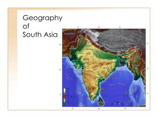
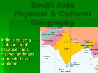
SECTION Landforms and Resources 1 Mountains and Plateaus The Indian Subcontinent • India, Pakistan, Bangladesh, Bhutan, Nepal, Sri Lanka, the Maldives • Subcontinent—large landmass that’s smaller than a continent - called Indian Subcontinent because India dominates the region • Though half the size of U.S., area has 1/5 of world’s people • Natural barriers separate subcontinent from rest of Asia - mountains form northern border, Indian Ocean surrounds rest - Arabian Sea to west, Bay of Bengal to east Continued . . . NEXT
SECTION 1 continuedMountains and Plateaus Northern Mountains • South Asia was once part of East Africa - split off 50 million years ago and collided with Central Asia - collision of tectonic plates pushed land into huge mountain ranges •Himalaya Mountains—1,500-mile-long system of parallel ranges - include world’s tallest mountain—Mt. Everest - form barrier between Indian subcontinent and China - kingdoms of Nepal, Bhutan are also in these mountains Interactive Continued . . . NEXT
SECTION 1 continuedMountains and Plateaus Northern Mountains • At west end, Hindu Kush mountains separate Pakistan, Afghanistan - historically blocked invasions from Central Asian tribes - Khyber Pass is one of the major land routes through the mountains •Karakoram Mountains are in northeastern part of Himalayas - include world’s second highest peak, K2 Image Continued . . . NEXT
SECTION 1 continuedMountains and Plateaus Southern Plateaus • Tectonic plate collision also created smaller mountain ranges - Vindhya Rang in central India •Deccan Plateau covers much of southern India •Western, Eastern Ghats: mountain ranges flank Deccan Plateau - block moist winds and rain, making Deccan mostly arid NEXT
SECTION 1 Rivers, Deltas, and Plains Great Rivers • Northern Indian, or Indo-Gangetic, Plain: - lies between Deccan Plateau, northern mountain ranges - is formed by three river systems that originate in Himalayas • Indus River flows west, then south through Pakistan to Arabian Sea • Ganges River flows east across northern India • Brahmaputra winds east, then west, south through Bangladesh • Ganges and Brahmaputra meet, form delta, flow into Bay of Bengal Chart Image Continued . . . NEXT
SECTION 1 continuedRivers, Deltas, and Plains Fertile Plains • Rivers irrigate farmlands, carry rich alluvial soil - overflow deposits this soil on alluvial plains—rich farmlands • Indo-Gangetic Plain has some of the world’s most fertile farms • Heavily populated area has 3/5 of India’s people - area’s big cities: New Delhi, Kolkata in India; Dakha in Bangladesh • Plain is drier to west between Indus, Ganges • The Thar, or Great Indian Desert, lies to the south NEXT
SECTION 1 Offshore Islands Sri Lanka: The Subcontinent’s “Tear Drop” •Island in Indian Ocean, off India’s southeastern tip • Large, tear-shaped country with lush tropical land • Range of high, rugged, 8,000-foot mountains dominate center •Many small rivers flow from mountains down to lowlands • Northern side has low hills, rolling farmland • Island is circled by coastal plain, long palm-fringed beaches Image Continued . . . NEXT
SECTION 1 continuedOffshore Islands The Maldives Archipelago • Maldives is archipelago—island group—of 1,200 small islands - stretch north to south for 500 miles off Indian coast, near equator • Islands are atolls—low-lying tops of submerged volcanoes - surrounded by coral reefs, shallow lagoons • Total land area of Maldives is 115 square miles - only 200 islands are inhabited Image NEXT
SECTION 1 Natural Resources Water and Soil •Water and soil resources provide food through farming, fishing • River systems help enrich land with alluvial soil, water - large- and small-scale irrigation projects divert water to farmlands • Types of fish include mackerel, sardines, carp, catfish • Waters provide transportation, power - India, Pakistan work to harness hydroelectric power Continued . . . NEXT
SECTION 1 continuedNatural Resources Forests • Indian rain forests produce hardwoods like sal and teak - also bamboo and fragrant sandalwood • Bhutan’s and Nepal’s highland forests have pine, fir, softwoods • Deforestation is a severe problem - causes soil erosion, flooding, landslides, loss of wildlife habitats - overcutting has devastated forests in India, Bangladesh, Sri Lanka Image Continued . . . NEXT
SECTION 1 continuedNatural Resources Minerals • India is fourth in world in coal production, has petroleum, uranium • Pakistan, Bangladesh have natural gas resources • Iron ore from India’s Deccan Plateau used in steel industry, exported • Other minerals: manganese, gypsum, chromium, bauxite, copper • India has mica for electrical equipment and growing computer industry • India is known for diamonds; Sri Lanka for sapphires, rubies Interactive NEXT
Section 2 Climate and Vegetation • Climate conditions in South Asia range from frigid cold in the high mountains to intense heat in the deserts. • Seasonal winds affect both the climate and vegetation of South Asia. NEXT
SECTION Climate and Vegetation 2 Climate—Wet and Dry, Hot and Cold Climate Zones • Cold highland zone in Himalayas, other northern mountains • Humid subtropical in foothills (Nepal, Bhutan), Indo-Gangetic Plain • Semiarid zone of west Plain, Deccan Plateau is warm with light rain • Desert zone covers lower Indus Valley, west India, south Pakistan - Thar Desert is driest area, with 10 inches of rain annually • Tropical wet zone in Sri Lanka and coasts of India, Bangladesh - Cherrapunji, India, holds rainfall record—366 inches in one month Image Continued . . . NEXT
SECTION 2 continuedClimate—Wet and Dry, Hot and Cold Monsoons and Cyclones • Monsoons—seasonal winds that affect entire region - dry winds blow from northeast October–February - moist ocean winds blow from southwest June–September - moist winds bring heavy rainfall, especially in southwest, Ganges Delta - unpredictable; cause hardship in lowlands of India, Bangladesh • Cyclone—violent storm with fierce winds, heavy rain - in Bangladesh low coastal region swamped by high waves NEXT
Section 3 Human-Environment Interaction • Rivers play a central role in the lives of South Asians. • Water pollution and flooding pose great challenges to South Asian countries. NEXT
SECTION Human-Environment Interaction 3 Living Along the Ganges Mother Ganges • Ganges is the best-known South Asian river - it’s shorter than the Indus, Brahmaputra - flows 1,500 miles from Himalayan glacier to Bay of Bengal - drains area three times France; home to 350 million people • Provides drinking and farming water, transportation • Known as Gangamai—“Mother Ganges” - becomes the Padma where it meets the Brahmaputra Map Continued . . . NEXT
SECTION 3 continuedLiving Along the Ganges A Sacred River • Hinduism is the religion of most Indians • To Hindus, the Ganges River is the sacred home of the goddess Ganga • Hindus believe waters have healing powers; temples line its banks - pilgrims come to bathe, scatter ashes of dead - at sacred site of Varanasi they gather daily for prayer, purification - float baskets of flowers, burning candles on water Continued . . . NEXT
SECTION 3 continuedLiving Along the Ganges A Polluted River • Centuries of use have made Ganges most polluted river in world - sewage, industrial waste, human bodies poison the water - users get stomach and intestinal diseases, hepatitis, typhoid, cholera • In 1986, government plans sewage treatment plants, regulations - today few plants are operational, factories still dump waste • Clean up will take time, money, a change in how people see river NEXT
SECTION 3 Controlling the Feni River A River Overflows • Feni River flows from Chittagong Hills to Bay of Bengal • Wide, slow-moving river flows through low-lying coastal plain - flat, marshy area floods during wet season due to monsoon rains • Cyclones bring storm surges—high waters that swamp low areas - sea water surges up river into flatlands, flooding villages • In 1980s, Bangladesh builds earthen dam over river’s mile-wide mouth Continued . . . NEXT
SECTION 3 continuedControlling the Feni River Using People Power • Bangladesh uses large population’s unskilled workers to build dam • Use cheap materials, low-tech process - lay bamboo mats, weight with boulders, cover with bags of clay • Build partial closure, then close Feni completely February 28, 1985 - when tide goes out 15,000 workers fill gaps with 600,000 bags - seven hours later the dam is closed Continued . . . NEXT
SECTION 3 continuedControlling the Feni River Completing the Dam • Dump trucks, earthmovers raise clay dam to height of 30 feet - put concrete, brick over sides, build road on top • South Asia’s largest estuary—arm of sea at river’s lower end—dam • Dam holds against cyclones and storm surges - villages and lands are protected NEXT