Download
1 / 31
310 likes | 505 Views
Seismic Imaging of Seneca and Cayuga Lakes:. Christopher A. Scholz Syracuse University cascholz@syr.edu http://rifts.syr.edu. Collaborators:. New York State Museum Financial support from New York State Energy Research Development Authority In-kind processing support from

E N D
Seismic Imaging of Seneca and Cayuga Lakes: Christopher A. ScholzSyracuse University cascholz@syr.eduhttp://rifts.syr.edu
Collaborators: New York State Museum Financial support from New York State Energy Research Development Authority In-kind processing support from Sterling Seismic Services, Ltd.
Cruise participants: Syracuse Univ. Chris Scholz Mike McGlue Peter Cattaneo Kiram Lezzar Nick Peters Bob Lyons RJ Hartwell Phil Arnold New York State Museum Rich Nyahay Justin Deming Courtney Lugert Rose Schulze Brian Slater Hobart-William Smith Colleges John Nichols John Abbott John Halfman
Earth Satellite Corp.,1997, Remote Sensing and Fracture Analysis for Petroleum Exploration of Ordovician to Devonian Fracture Reservoirs of New York
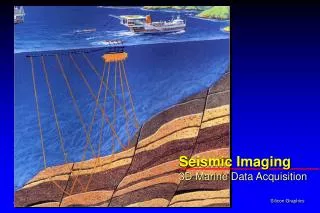
Outline • Small Lake Seismics: Acquisition issues and parameters: Practical experiences from the Finger Lakes • Data processing efforts • Preliminary interpretations and key geologic features • The October ’02 Survey – what worked and what didn’t
Acquisition Parameters • Approach: Simpler is better!!! • 24-bit recording • 12-fold data • 12.5 m groups; ~625 m total offset • 5 m streamer depth; 2 m gun depth • Differential GPS acquisition (sub-meter accuracy) • Streamer leveling: Digicourse Birds
Acquisition Equipment • OYO DAS-1 48-channel, Digital Seismic Acquisition System • ELICS Delph2 high-resolution seismic acquisition system (for real-time QC) • 2 x 40 c.i. I-O Sleeve Gun airgun array • Portable diesel-powered seismic air compressors (58 SCFM total) • Single channel streamer (for real-time QC) • 48 Ch. 600 m (active) ITI Stealth array seismic streamer w/ 150 m lead-in (Primary Streamer)
Acquisition Challenges • Small vessel • Short (but solid!) streamer • Crooked line navigation • Limited compressor capability…. • Streamer levelers marginal at slow shooting speeds • Limited daylight • Recreational boaters • Environmentally sensitive setting
Hobart William Smith Colleges R/V William Scandling, Seneca Lake
I-O Sleeve Gun Array (2 X 40 c.i. guns)
I-O Sleeve Gun Array (2 X 40 c.i. guns)
I-O Sleeve Gun Array (2 X 40 c.i. guns)
The October ‘02 Survey ~95 km total acquisition: Cayuga, Seneca – two axial lines each
Data Processing • Initial processing by SU, subsequent intensive processing by Sterling Seismic Services, Ltd. • Significant changes between Brute stack Enhanced stack Kirckhoff Migration Kirckhoff Migration + FK-filtering
Data Processing • Crooked line geometry • High-resolution radon demultiple routine • Kirckoff migration • FK filter
Lineaments Tracklines Inferred Fault Faults
Initial Observations • Up to 200 m of Quaternary fill • Bedrock surface follows regional dip • Rugged bedrock topography – tracklines not uniformly on top of bedrock thalweg • Considerable relief on high-amplitude events below Quaternary fill !?! • Offsets on Paleozoic reflections – 20 ms or more
Exposed bedrock Apparent Offsets
Survey Challenges – Post-mortem • Seismic source constraints – not a limiting factor • High velocity section – perhaps the major issue; longer streamer preferable • Thick Quaternary fill and narrow bedrock valley – side echo effects not a major problem, but complex bedrock surface morphology had major impact • Limited budget and cruise window – processing budget; cruise window limiting factor = amount of daylight available • Limited number of nearby wells, with full log suites