Download
1 / 8
90 likes | 243 Views
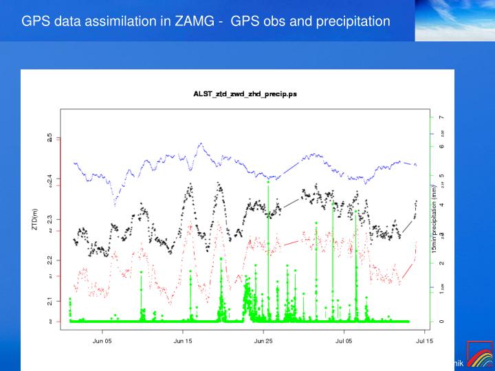
GPS data assimilation in ZAMG - GPS obs and precipitation. GPS data assimilation in ZAMG - data sources. E-GVAP network (only available for 2009 case study). Austrian network 41 stations ~40km resolution. GPS assimilation in ZAMG – OBSOUL preparation. Treated as Synop observation.

E N D
GPS data assimilation in ZAMG - data sources E-GVAP network (only available for 2009 case study) Austrian network 41 stations ~40km resolution
GPS assimilation in ZAMG – OBSOUL preparation Treated as Synop observation 20100513 6 17 1 1003110 48.716 15.329 'ALSTTUAT' 20100513 60000 543.1 1 11111 0 128 60.0 5.50000E-04 2.266150 2147483647 Then merged with conventional observation Obsoul files
GPS assimilation in ZAMG – running environment • 32T1 for assimilation procedure • 35T1 for forecast • 60 vertical level • No surface data assimilatoin, surface taken from Arpege. • White list approach – station selection before Bator - gaussian distribution - temporal availability - inter-distance - altitude difference
GPS assimilation in ZAMG – Experiment design • CONV • CONV + GPS No comparasion between Operational / CONV + GPS Difficulty to distinguish impacts from CONV or GPS. Cycling period: 2009 June 15- July 24 2010 May 01 – June 30
GPS assimilation in ZAMG – results • For upper air : Main impacts on humidity in lower-mid level. • For SAL precipitation score: 1) Use of GPS data generally improves slightly the SAL location score. 2) Proper bias correction (use different bias correction for dry and wet season) improves SAL amplitude score. 3) Proper thinning / exclusion of problematic stations (mountain stations) improves SAL structure score. ---- high density GPS station usage does not lead to better results due to big length scale.
GPS assimilation in ZAMG – GPS obs density issue Humidty increment for 1 GPS obs (+ fg) Humidty increment when all austrian GPS obs assimilated
GPS assimilation in ZAMG – questions • Is it possible to decrease the length scale? • Increase the weight of GPS observation? Looking forward to the advice from the other LACE colleagues!