Download
1 / 1

E N D
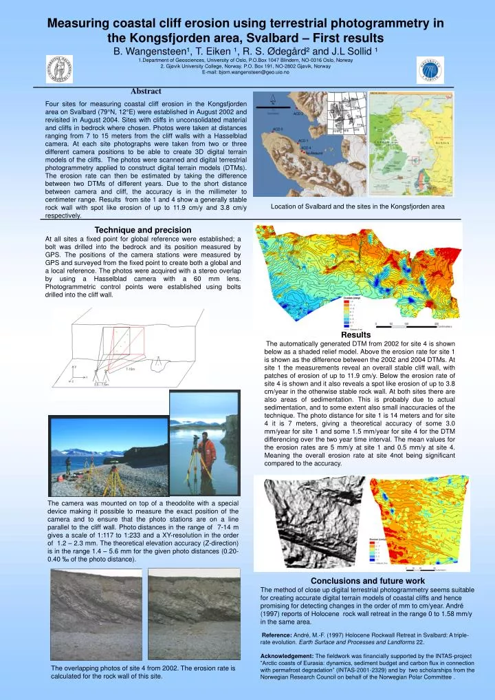
Measuring coastal cliff erosion using terrestrial photogrammetry in the Kongsfjorden area, Svalbard – First resultsB. Wangensteen¹, T. Eiken ¹, R. S. Ødegård² and J.L Sollid ¹1.Department of Geosciences, University of Oslo, P.O.Box 1047 Blindern, NO-0316 Oslo, Norway2. Gjøvik University College, Norway. P.O. Box 191, NO-2802 Gjøvik, NorwayE-mail: bjorn.wangensteen@geo.uio.no Abstract Four sites for measuring coastal cliff erosion in the Kongsfjorden area on Svalbard (79°N, 12°E) were established in August 2002 and revisited in August 2004. Sites with cliffs in unconsolidated material and cliffs in bedrock where chosen. Photos were taken at distances ranging from 7 to 15 meters from the cliff walls with a Hasselblad camera. At each site photographs were taken from two or three different camera positions to be able to create 3D digital terrain models of the cliffs. The photos were scanned and digital terrestrial photogrammetry applied to construct digital terrain models (DTMs). The erosion rate can then be estimated by taking the difference between two DTMs of different years. Due to the short distance between camera and cliff, the accuracy is in the millimeter to centimeter range. Results from site 1 and 4 show a generally stable rock wall with spot like erosion of up to 11.9 cm/y and 3.8 cm/y respectively. Location of Svalbard and the sites in the Kongsfjorden area Technique and precision At all sites a fixed point for global reference were established; a bolt was drilled into the bedrock and its position measured by GPS. The positions of the camera stations were measured by GPS and surveyed from the fixed point to create both a global and a local reference. The photos were acquired with a stereo overlap by using a Hasselblad camera with a 60 mm lens. Photogrammetric control points were established using bolts drilled into the cliff wall. Results The automatically generated DTM from 2002 for site 4 is shown below as a shaded relief model. Above the erosion rate for site 1 is shown as the difference between the 2002 and 2004 DTMs. At site 1 the measurements reveal an overall stable cliff wall, with patches of erosion of up to 11.9 cm/y. Below the erosion rate of site 4 is shown and it also reveals a spot like erosion of up to 3.8 cm/year in the otherwise stable rock wall. At both sites there are also areas of sedimentation. This is probably due to actual sedimentation, and to some extent also small inaccuracies of the technique. The photo distance for site 1 is 14 meters and for site 4 it is 7 meters, giving a theoretical accuracy of some 3.0 mm/year for site 1 and some 1.5 mm/year for site 4 for the DTM differencing over the two year time interval. The mean values for the erosion rates are 5 mm/y at site 1 and 0.5 mm/y at site 4. Meaning the overall erosion rate at site 4not being significant compared to the accuracy. The camera was mounted on top of a theodolite with a special device making it possible to measure the exact position of the camera and to ensure that the photo stations are on a line parallel to the cliff wall. Photodistances in the range of 7-14 m gives a scale of 1:117 to 1:233 and a XY-resolution in the order of 1.2 – 2.3 mm. The theoretical elevation accuracy (Z-direction) is in the range 1.4 – 5.6 mm for the given photo distances (0.20-0.40 ‰ of the photo distance). Conclusions and future work The method of close up digital terrestrial photogrammetry seems suitable for creating accurate digital terrain models of coastal cliffs and hence promising for detecting changes in the order of mm to cm/year. André (1997) reports of Holocene rock wall retreat in the range 0 to 1.58 mm/y in the same area. Reference: André, M.-F. (1997) Holocene Rockwall Retreat in Svalbard: A triple-rate evolution. Earth Surface and Processes and Landforms 22. Acknowledgement: The fieldwork was financially supported by the INTAS-project “Arctic coasts of Eurasia: dynamics, sediment budget and carbon flux in connection with permafrost degradation” (INTAS-2001-2329) and by two scholarships from the Norwegian Research Council on behalf of the Norwegian Polar Committee . The overlapping photos of site 4 from 2002. The erosion rate is calculated for the rock wall of this site.