Download
1 / 17
250 likes | 637 Views
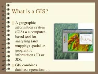
Geographic Information System [GIS]. Continuum E. Atlas--------Thematic Mapper--CAC----------GIS. GIS Characteristics. Fully Dynamic Computer Based Describes, Predicts, Prescribes Display & Analytical Flexibility Up to the user Up to the minute Storage Device

E N D
Geographic Information System [GIS] Continuum E. Atlas--------Thematic Mapper--CAC----------GIS GIS Definition & Key Elements
GIS Characteristics • Fully Dynamic Computer Based • Describes, Predicts, Prescribes • Display & Analytical Flexibility • Up to the user • Up to the minute • Storage Device • Ideal location to store, edit, organize, & manage large spatial data sets • Extremely flexible – input/output GIS Definition & Key Elements
GIS Uses • Analysis • Available for scientific studies • Management • Can assist in managing a resource • Planning • An essential tool in the process • Education • An ideal way to provide spatial and temporal understanding GIS Definition & Key Elements
Defining GIS 1: Scholarly • …an information system that is designed to work with data referenced by spatial or geographic coordinates…Star & Estes, 1990 • [Where] an information system is that chain of operations that takes us from planning the observation and collection of data, to storage and analysis of the data to the use of the derived information in some decision-making process.”Calkins & Tomlinson, 1977 GIS Definition & Key Elements
The 5 GIS Elements or chain of operations for implimenting an Information System After setting an objective • Data Acquisition • Data Preprocessing • Database Management • Data Manipulation and Analysis • Product Generation • This process is not simply linear but recursive and iterative GIS Definition & Key Elements
GIS Definition 2: Practical • A process that proceeds through the 5 essential elements from data acquisition through to final product generation – continuously (iterative & recursive) • Based on a defined goal or set of objectives (what to accomplish) • Where the spatial nature of the data is essential to successful application • Normally using a computer software package(s) GIS Definition & Key Elements
GIS – relating to E. Atlas and Them. Mapper • Geographic Database software in either vector or raster format • Fully dynamic and involves geographic database – acquisition, preprocessing & storage, manipulations & analysis, and output production (see 5 elements note it is an information system) • Data stored in flexible electronic tables containing entities, attributes, and geocodes • Can continually add data • Data can be manipulated and updated at will • Limitless Choice of analyses & outputs • Can interface with sophisticated modeling tools for analysis, new uses continuously being discovered GIS Definition & Key Elements
Key Elements of a GIS (review) • Entities – spatial objects • Points • Lines • Polygons • Attributes –characteristics or variables • Descriptors of an entity • Attached to an entity • Geocodes • Coordinates that places an entity in space GIS Definition & Key Elements
How the Key Elements Work • Geocodes locate and anchor Entities in space while Attributes describe these entities GIS Definition & Key Elements
How the Key Elements Work Example – Bellingham is • located at Lat. 48.75 Long. 122.45 (geocode) • Represented by a point (entity) • Has a population of 81,454 (attribute) GIS Definition & Key Elements
Entities Attributes GeoCodes GIS Definition & Key Elements
Geographic Information Systems (GIS) Review • GIS is a system of hardware and software used for storage, retrieval, managing, analysis, and mapping or display of geographic/spatial data. • Spatial features or data are stored in a coordinate system (latitude/longitude, state plane, UTM, etc…), • which references a particular place on the earth. • Descriptive attributes in tabular form are associated with spatial features. GIS Definition & Key Elements
Geographic Information Systems (GIS) Review • Spatial data (geocoded entities) and associated attributes in the same coordinate system can be layered together for mapping and analysis. • GIS can be used for: • scientific investigations • teaching, • resource management, • development planning, • marketing, • political campaigns, • emergency management… GIS Definition & Key Elements
List of GIS Software Programs ArcMap GIS Definition & Key Elements
Website of uses of GIS in Transportation Planning http://www.gis.fhwa.dot.gov/ GIS Definition & Key Elements
Website of uses of GIS in K-12 Education http://oregonstate.edu/~rynersoe/ GIS Definition & Key Elements
Website of uses of GIS in National Park Management http://www.nps.gov/history/hdp/standards/CRGIS/katrina.htm GIS Definition & Key Elements