Download
1 / 24
240 likes | 593 Views
Update on the UW-CIMSS Advanced Dvorak Technique (ADT). Tim Olander, Chris Velden and Tony Wimmers University of Wisconsin – Madison Cooperative Institute for Meteorological Satellite Studies (CIMSS). Meteorological Satellite (METSAT) Conference Ford Island Conference Center

E N D
Update on the UW-CIMSSAdvanced Dvorak Technique (ADT) Tim Olander, Chris Velden and Tony Wimmers University of Wisconsin – Madison Cooperative Institute for Meteorological Satellite Studies (CIMSS) Meteorological Satellite (METSAT) Conference Ford Island Conference Center Pearl Harbor, HI 27-28 April 2009 Research supported by SPAWAR PEO C41&Space/PMW 180 and the ONR Marine Meteorology Program via NRL-Monterey
Advanced Dvorak Technique (ADT) Presentation Overview • Current Status • ADT Auto-Centering Technique • Experiments Incorporating Polar-Orbiter Microwave Data • New Channel-Differencing Technique • If time permits
Advanced Dvorak Technique (ADT) ADT – Current Status • Algorithm Version 7.2.3 Latest fully-automated CIMSS-demonstrated version now operational at NESDIS-SAB. • Algorithm Version 8.0 Latest experimental version will be run simultaneously with 7.2.3 at CIMSS this coming TC season, and perhaps at SAB as well. Real-time intensity estimates will be available via CIMSS web site, and/or ATCF.
Advanced Dvorak Technique (ADT) ADT Auto-Centering Current ADT Automated Storm Center Determination Algorithm
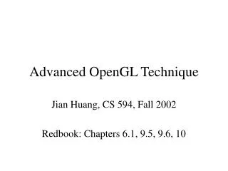
Advanced Dvorak Technique (ADT) ADT Auto-Centering Initial Storm Center Determination • Utilize Infrared Window (IR) Channel Imagery • Works with any geostationary satellite IR imagery • Spiral Centering • “First guess” center position interpolated from TC forecast (JT or NHC) • Fits 5° log spiral vector field to the IR image (entire TC cloud top temps) • Calculates a grid of scores that indicates the alignment between the spiral field and the IR Tb gradients (maximum at the spiral center) • Spiral centering scores modified based on distance from first guess • If modified score exceeds empirically-derived threshold, position is used • Ring Fitting (if IR-determined eye present) • Spiral centering maximum serves as first guess center position • Calculates a grid of scores that indicates the best fit (Tb gradients) to a range of possible ring positions and diameters (maximum at the eye center) • If score exceeds empirically-derived threshold, position is used • Additional logic to identify and avoid “false eye” (moat) regions • Combined Analysis (if a Ring Score is successful) • Finds ‘final’ position where the sum of the spiral and ring scores is greatest
Advanced Dvorak Technique (ADT) ADT Auto-Centering • Spiral Centering • Fits 5° log spiral vector field to the IR Tb image • Calculates a grid of scores that indicates the alignment between the spiral field and the IR Tb gradients (maximum at the spiral center) • Ring Fitting • Calculates a grid of scores that indicates the best fit to a range of possible ring positions and diameters (maximum at the eye center)
Advanced Dvorak Technique (ADT) ADT Auto-Centering Super Typhoon 20P (Percy) 27 February 2005 11:25 UTC GOES-10 Spiral Centering Spiral Analysis Center “coarse fit” Official Forecast “First Guess” Ring Fitting Combined Method Final ADT Storm Center Best Ring Fit “fine adjustment”
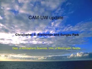
Advanced Dvorak Technique (ADT) Experimental MW-Based Analysis Microwave TC Centering Methodology • Utilize Microwave 85-92GHz imagery • SSMI, SSMIS, AMSRE, and TMI • Also utilizes an official forecast Vmax from JT/NHC as input • Motivation • Spiral and ring centering is more effective in MW (compared to IR) especially during CDO situations • Overall • Follows same general methodology as IR auto-centering technique described earlier • Main differences limited to internal weights/threshold values • And unlike the IR method, the algorithm internal parameters vary with the first-guess Vmax (looser with low Vmax, stricter with high Vmax) • This algorithm is not yet directly a part of the ADT input, but may become so in a future ADT version
Advanced Dvorak Technique (ADT) Experimental MW-based Analysis Legend:ΔOfficial Best Track+First Guess □ Final Answer MW Close Up Initial MW image TRMM TMI 21 August 2007 22:19 UTC Best Track Vmax: 71kts Spiral Analysis Score Field Ring Analysis Score Field Combined Analysis Score Field Maximum is eye center position estimate
Advanced Dvorak Technique (ADT) Experimental MI Analysis Experimental Objective Microwave-based Intensity (MI) Determination Algorithm
Advanced Dvorak Technique (ADT) Experimental MI Analysis Background and Motivation • Experimental ADT algorithm V8.0 utilizes external passive microwave information from polar orbiters to aid in detection of tropical cyclone eye formation when objective IR-based scene identification schemes cannot discern an eye feature. • The current ADT algorithm struggles with situations where high-level cirrus (from tropical cyclone convection) can obscure the IR sensor from observing the formation of an eye feature in developing TCs. MW data can observe through the cirrus to the convective cloud structure below in most cases.
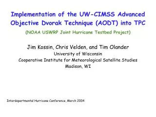
Microwave Image – AMSRE 09 Sept 2008 /17:08:28UTC Eye Region Depicted In MW Imagery Advanced Dvorak Technique (ADT) Experimental MI Analysis Infrared Image 09 Sept 2008 /17:30UTC No Eye Apparent in IR Imagery “Dvorak” Enhancement 09 Sept 2008 /17:30UTC
Advanced Dvorak Technique (ADT) Experimental MI Analysis • Experimental Passive MW Intensity Estimation Approach • Purely objective and automated • Currently utilized only in developing TCs with emerging eyes • Summary • Uses MW 85-92 GHz brightness temperature structure in the TC core region • Provides intensity estimate categories for developing TCs • < 65 knots • 65-85 knots • > 85 knots • Has been tested as ADT input since early 2008 Eyewall temperatures Warmest eye pixel Hurricane Dolly, 23 July 2008 1126 UTC DMSP SSM/I 85GHz (H) brightness temperature
Advanced Dvorak Technique (ADT) Experimental MI Analysis Max Wind Speed Estimate Determination • Calculate two “discriminator” values • “Tb Difference” • Maximum temperature difference between warmest pixels in eye and eyewall regions (similar to Dvorak EIR) • “Completeness” of eye wall (higher of two values) • Fraction of pixels : (Tbeye - Tbeyewall) > 20K • Fraction of pixels < 232K • Final ‘Score’: combination of two values • “Tb Difference” score: +1 score pt for every 1° Tb difference • “Completeness” score:>.85, add 15 score points • 0(no eyewall) to 100+(strong eyewall) • Scorebetween 20 – 60 :likely above65 knots • Scoregreater than 60 : likely above85 knots
Advanced Dvorak Technique (ADT) Experimental MI Analysis The microwave module has been validated in the Atlantic • Validation of microwave estimates on an independent sample of Atlantic hurricanes (recon-aided Best Track) shows that the microwave module makes reliable, conservative estimates of cyclone intensity for the critical Vmax thresholds of >65 knots and >85 knots.
Advanced Dvorak Technique (ADT) Experimental MI Analysis • MI eye score is calculated and passed to the ADT • Input is controlled via automated parameter values • ADT uses this score value to reset the current intensity of the storm (time of MI data) to one of two values • MI value : 65-85 knotsADT T# = 4.5 (77 kts) • MI value : > 85 knots ADT T# = 5.2 (94 kts) • Value will then be “merged” value into the ADT storm history file • IR-based Adjusted Raw T#, Final T# and CI# values are modified over previous 12 hours via linear interpolation • Original (IR) Raw T# values from ADT are left alone for post analysis • Avoids unnatural intensity jumps in the record • Once an eye scene appears in three consecutive ADT IR-based analyses, MI values are no longer used (ADT does well with these scene types, and the MI intensity estimate precision declines after the TC eye formation stage (work in progress))
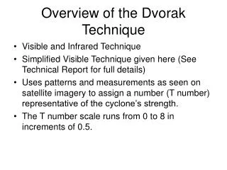
Advanced Dvorak Technique (ADT) Experimental MI Analysis Validation of Experimental ADT Version with MI 2008 Atlantic Season TC intensity estimates versus aircraft reconnaissance 299 matches – Independent Sample
Advanced Dvorak Technique (ADT) Experimental MI Analysis Eliminated false intensity plateau; Closer to Best Track maximum intensity More closely follows rapid intensification; More accurate maximum intensity resulted
Advanced Dvorak Technique (ADT) Summary • Experimental ADT w/ MI Estimates • MI technique is now fully functional within experimental (ver 8.0) ADT • Real time output will appear on the CIMSS TC web site during the 2009 TC season (can also be made available on ATCF for JTWC analysis) • Plan to also implement experimentally at NOAA/SAB during 2009 season for independent assessment
Advanced Dvorak Technique (ADT) ADT Access Information • ADT Real-Time Estimates • http://cimss.ssec.wisc.edu/tropic2/real-time/adt • Global TC coverage • Completely automated • ADT Overview and Archive • http://cimss.ssec.wisc.edu/tropic2/misc/adt • Online publications and technique history • Storm archive from 2003 to current Or just go to the CIMSS Tropical Cyclone webpage at : http://cimss.ssec.wisc.edu/tropic2 and click on “Our Research / ADT”
Advanced Dvorak Technique (ADT) Thanks The UW-CIMSS TC Research Group again thanks Jeff Hawkins from NRL-MRY and the ONR and SPAWAR sponsors for their continuing and committed support for this work, and the operational units at JTWC, SAB and NHC for their constructive feedback and evaluation
Advanced Dvorak Technique (ADT) Looking Ahead Looking Ahead - An Additional Multispectral ADT Enhancement? : Infrared Window – Water Vapor Channel Differencing
Advanced Dvorak Technique (ADT) IR-WV Channel Differencing • IR-WV difference field easy to compute/analyze; Derived imagery easy to examine qualitatively • Derived IRWV field canaid in storm centerdetermination • Can provide better information on regions of strongest convection and trends • Correlations between TC core-averaged IRWV signal and observed intensity exhibit predictive quality, especially in 12-24 hour range Stretched IR Image (IR-WV locations only) IR Image IR Image (w/ BD enh) Derived IR-WV Image