Download
1 / 36
840 likes | 1.84k Views
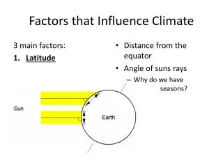
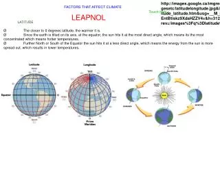
Six factors that influence climate. Climate:. Latitude. Latitude. Click to view a map showing today's high temperatures in the world As you examine the map, answer these questions: 1. How does the color scale tell you the temperatures?

E N D
Six factors that influence climate Climate:
Latitude • Click to view a map showing today's high temperatures in the world • As you examine the map, answer these questions: 1. How does the color scale tell you the temperatures? 2. What is the trend in the data for temperatures? (look for a pattern connecting temperature and latitude).
Latitude • Higher latitudes (further away from the equator you go (North or South) the cooler the climate becomes. Highest latitude = 90o • Lower latitudes (closer to the Equator), the warmer climate becomes. Equator = 0o Colder Warmer
City Comparisons - latitude Predict the temperature difference between Lincoln, Nebraska and Dallas, Texas, based on their locations. Then click on the links below to see their data. Lincoln, Nebraska Dallas, Texas Friedman’s Climate Page
Elevation data • Click the link to visit Google Maps. Make sure you have clicked the “satellite” box. Drag the map around, and find the snow-capped mountains (they are white on top).
Elevation • Temperature typically drops 3.5o F for each 1,000 feet higher in elevation. • Altitude in Denver, CO – 5,280 ft above sea level. • Average summer temp – 73oF • Average winter temp – 31oF • Baltimore, MD has the same latitude as Denver, but different altitude (446 ft above sea level) • Average summer temp – 80oF • Average winter temp – 38oF
Elevation Question • Summarize the effect that elevation has on climate. More to explore... Why???
Topography • Topography – surface features including mountain ranges, valleys, etc.
City examples • Seattle vs Wenatchee • Approximately the same latitude • Approximately the same altitude Seattle: 3” rain/mo average, 40” rain/year Wenatchee: 0.75” rain/mo average, 9” rain/year
Seattle, WA vs. Wenatchee WA Cascade Mountains
The “Rain Shadow” Effect By the time the air has gone over the mountain, it is dried out, leading to a desert. Wind direction The air drops its moisture on the way up the mountain range.
Another example of rain shadow http://www.sandwichislands.com/Graphics/rain.jpg
Buffalo, NY vs Albany, NY Lake Erie
Oceans and Large Lakes Surface currents are caused by winds, but the currents affect the winds as well. Winds pick up moisture as they blow across warm water currents, bringing warm, moist air to coastal regions. Cool water currents cause the winds blowing over them to cool, bring cool dry air to coastal regions.
“Lake Effect” Snow Can you see the Great Lakes under the clouds?
Windward vs. Leeward Wind usually blows from thisdirection Windward side of lake Leeward side of lake
The ocean stores energy from the Sun The ocean heats and cools more slowly than land, because the ocean stores energy in the water Land heats and cools more quickly, because only the top layer gets heated, and this energy is quickly given off (that’s why the desert that is hot during the day can be cold at night)
Ocean Keeps Winter Mild In winter, the ocean cools more slowly than the land; therefore, temperatures at the coast are not as cold as inland temperatures. . Maryland is not as cold as Iowa in winter.
Ocean City, MD is not as cold as Ijamsville, MD in winter Ijamsville Ocean City
Ocean Keeps Summer Mild In summer, the ocean heats more slowly than the land; therefore, temperatures at the coast are not as hot as inland temperatures.
Ocean City, MD is not as warm as Ijamsville, MD in summer Ijamsville Ocean City
Earth’s Winds Prevailing Winds Winds that blow more often from one direction than the other.
Prevailing Winds Effect on Climate • These winds carry the moisture of the oceans and large lakes to the continents. • In the United States, weather fronts typically move from west to east because of the wind.
Earth’s Winds Prevailing Winds Winds that blow more often from one direction than the other. These winds carry the moisture of the oceans and large lakes to the continents. In the United States, weather fronts typically move from west to east because of the wind.
X A B D E C F G H Y Discussion Questions Which is colder, X or Y? Which has a bigger temperature range, G or H? Which is colder, B or C? Which gets more snow, D or E? Which would likely get a storm first, C or D? Why does A get so much rain?
Land near cool currents has cooler temperatures. Land near warm currents has warmer temperatures.