Download
1 / 55
690 likes | 956 Views
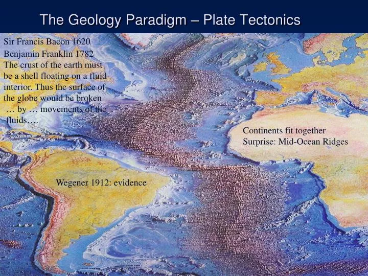
The Geology Paradigm – Plate Tectonics. Sir Francis Bacon 1620. Benjamin Franklin 1782 The crust of the earth must be a shell floating on a fluid interior. Thus the surface of the globe would be broken … by … movements of the fluids…. Continents fit together

E N D
The Geology Paradigm – Plate Tectonics Sir Francis Bacon 1620 Benjamin Franklin 1782 The crust of the earth must be a shell floating on a fluid interior. Thus the surface of the globe would be broken … by … movements of the fluids…. Continents fit together Surprise: Mid-Ocean Ridges Wegener 1912: evidence
Fit of continents, fossil evidence, continuation of • rock types and mountain belts , paleoclimatic evidence Continental drift: An idea before its time • Alfred Wegener • Proposed hypothesis in 1915 • Published The Origin of Continents and Oceans • Continental drift hypothesis • Supercontinent Pangaea began breaking apart about 200 million years ago
Fit of Continents: Pangaea approximately 200 million years ago Especially good agreement if continental shelf is included. Coastlines FitMountain Ranges line up
Paleoclimatic evidence for Continental Drift Ancient glaciers line up if continents together
Seafloor spreading hypothesiswas proposed by Harry Hess in the early 1960s During WWII, Harry kept his depth sounder on, collected huge amounts of data. Together with data from other ships, the data show mid-ocean ridges. HarrY: The earth’s internal heat, and the flow it causes in the mantle, is responsible for sea-floor spreading at the mid-ocean ridges. http://www.amnh.org/education/resources/rfl/web/essaybooks/earth/p_hess.html
Harry Hess: Mid-ocean ridges are spreading apart due to heat flow in the mantle. Crust moves apart as if on conveyer belts. New lava fills the cracks due spreading, new ocean floor from frozen lava
Origin of new Ocean Floor At the Mid-Ocean Ridge 1_20 Mid-ocean Ridge • Mantle material is move to the surface. • Lithosphere (Crust + Upper Mantle) bulges into a mid-ocean ridge. • Added heat causes lithosphere to expand. It cracks, exposing the mantle to low pressures • Some of the Mantle minerals are unstable at atmospheric pressures • The unstable minerals melt forming lavas, which cool into basalt, the main rock of ocean lithosphere.
Vine F.J. and Matthews D.H. Magnetic anomalies over oceanic ridges. Nature 199, 947-949, 1963.- Vine F.J. Spreading of the ocean floor: new evidence. Science 154, 1405-1415, 1966.- Vine F.J. and Hess H.H. Sea-floor spreading. In: The Sea - Vol. IV, pt 2. edited by A.E. Maxwell. Wiley-Interscience, New York. p.587-622, 1971. • How to test further? Fred Vine and Drummond Matthews: How about geomagnetic reversals? • Earth's magnetic field periodically reverses polarity – north magnetic pole becomes south magnetic pole, and vice versa • Dates when polarity of Earth’s magnetism changed were determined from lava flows
Testing the Hess Hypothesis • Magnetized minerals in seafloor lavas show direction to Earth’s magnetic poles • Provide a means of determining the original latitude of the rocks when they formed. • Testable consequences: If continents moved, old lavas should show different latitude
Some Tests: So, they checked. Symmetrical, NOT FALSE
Another test: Oceanic Crust youngest at ridges? Also NOT FALSE Hess model prediction: youngest at ridges, oldest at trenches
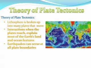
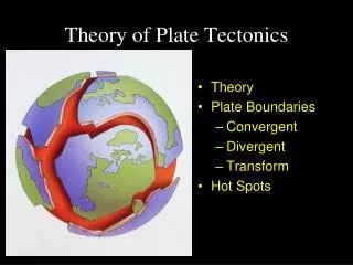
Plate tectonics: The new paradigm • Earth’s major plates • Associated with Earth's strong, rigid outer layer • Known as the lithosphere • Consists of uppermost mantle and overlying crust • Overlies a weaker region in the mantle called the aesthenosphere. The Aesthenosphere is hot and plastic, and sheds heat via convective currents.
Structure of three boundary types
Mantle circulations are an example of convection, heat transfer by moving fluids This example shows transfer of core heat to the upper mantle and crust
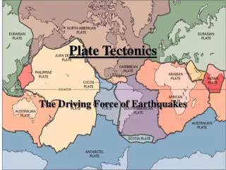
Convergent plate boundary Divergent plate boundary Transform plate boundary 180º 90º 0º 90º 180º 1_15 Mid-Atlantic Ridge 45º 45º NORTH EURASIAN AMERICAN PLATE JUAN DE PLATE PACIFIC FUCA PLATE PLATE ARABIAN PLATE PHILIPPINE CARIBBEAN PLATE PLATE AFRICAN COCOS 0º 0º PLATE PLATE FIJI SOUTH PLATE AMERICAN PLATE INDIAN- PACIFIC NAZCA AUSTRALIAN PLATE PLATE PLATE Mid-Atlantic SCOTIA Ridge PLATE 45º 45º ANTARCTIC PLATE ANTARCTIC PLATE 180º 90º 0º 90º 180º • Plates move relative to each other at a very slow but continuous rate • Average about 5 centimeters (2 inches) per year • Cooler, denser slabs of oceanic lithosphere descend into the mantle Seven major lithospheric plates Seven or so smaller ones. Plates are in motion and change in shape and size Largest plate is the Pacific plate Several plates include an entire continent plus a large area of seafloor
Assistant Professor Dirk Vogel, teaching Petrology at Rutgers, about 1971. It was Dr. Vogel who let the Plate Tectonics cat out of the bag at Rutgers. 1968 anecdote Rutgers and course work 1971- Vogel 1_22a Concept caused revelation. Yes, revelation. Earth’s many features were all caused by the same process. Subduction Zone same process as Andes CONTINENTAL PLATE CONTINENTAL PLATE Oceanic lithosphere being subducted Water driven out of ocean lithosphere Water hits mantle, which partially melts. Forms a deep basaltic magma (a) Fundamental Paradigm
Plate boundaries Each plate bounded by combination of all three boundary types: divergent, convergent, transform Edges marked by Earthquakes
How fast do Plates Move? • Hot Spots are magmas from rising plumes from the deep mantle, probably heated by the liquid outer core. Their lavas are datable • As plates move over them, new volcanic seamounts and islands are formed. Eventually any subaerial (exposed to the air) parts are eroded away, and as they move away from the Hot Spot, they cool, contract, and submerge. Called Guyots Hot spots form chains.
Hot Spots and Hawaii Speeds vary from 1 to 10 centimeters per year Flood Basalt was subducted Hey look, the direction changed!
Hot Spots & Plate Motions 1 -10 centimeters/year average 5
New ways of determining spreading rate LAGEOS and GPS satellites determine that plates move 1-10 cm per year, avg 5 Just find position wrt distant stars, then watch fixed objects on earth move .
Paleogeography Reconstructions • Orientation of magnetic minerals gives latitude (north or south of equator) • Radiometric dates of ocean floor basalts, plus distance from ridge, gives paleolongitude since 200 million years ago, when Pangaea began to break apart.
http://www.odsn.de/odsn/services/paleomap/animation.html 150 mya Atlantic is already open 110 mya Displaced (Exotic) Terranes from S. Am. hits W. N.Am. 60 mya another terrane forms Cuba, Hisp. About 50 mya Southern Ocean forms 20 mya Himalayas forms About 5-3.5 mya Central America forms
Note 3-D Triple Junction Active Rifting of A Continental Plate Discussion: eggshells
Inactive Branch: Aulocogen;Subsided Passive Margins Active Rifting of A Continental Plate
Active: Red Sea and Gulf of Aden Failed Arm: Great Rift Valley (aulocogen) East African Rift Zone Discussion: Fault Block Mountains, HA normal fault rain shadows, global cooling & grasslands Humans as tall savannah specialists, voice Story: The drunk and the lamp post
Mid-Ocean Ridge dimensions • Total 65000 kilometers (40,000 miles) long • As wide as 1500 km (900 miles) • Some more than 3 km high above ocean floor.
Mid-Ocean Ridge System Motion Fracture Zones and Transform Faults Shallow weak earthquakes
Subduction-Zone Features Note sequence from land to trench Note: over here are some ocean plate rocks that don’t get subducted in a collision We will see some on the field trip, as well as the volcanic arc If a continent converges from the left, what rocks will fold in the collision? Rocks in the Himalayas Reverse faults at convergent margin
Anatomy of a Continent Canadian Shield, North America’s Crystalline core exposed by glaciers
Shield + Platform = Craton High Angle Normal faults of Rift Escarpment
Collisions with Volcanic Island Arcs and microcontinents Exotic (Displaced) Terrains Continental Crust buoyant hard to subduct. Erosion resistant parts Suture Zones Pieces are volcanic island arcs, and microcontinents Accreted or moved by transform faults Anecdote Western California
Ideas: Earth's Convection Cells Combination
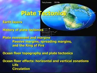
Mapping the ocean floor • Three major topographic units of the ocean floor • Continental margins • Deep-ocean basins • Mid-ocean ridges
A passive continental margin • Found along coastal areas that surround oceans w central MOR • Not near active plate boundaries • Little volcanism and few earthquakes • East Coast of USan example To MOR
Rifts and MOR’s the same divergent process, diff. place and/or age
An active continental margin • Continental slope descends abruptly into a deep-oceanic trench • Located primarily around the Pacific Ocean • Sediment and oceanic crust scraped off ocean crust to form accretionary wedges
The world’s trenches and ridges Trench an entrance to Subduction Zone, Ridges and Rises are Mid-Ocean Ridges
CONTINENT Back Arc Basin Volcanic Island Arc (Japan) Trench Abyssal Plain FAB Accretionary Wedge Seamounts
Features of the deep-ocean basin • Abyssal plains • Can be sites of thick accumulations of sediment • Found in all oceans • Studded by old cold seamounts and ridges See previous slide
Seafloor sediment • Ocean floor is mantled with sediment • Sources • Turbidity currents on continent margins • Sediment that slowly settles to the bottom from above – fine mud and plankton • Thickness varies • Thickest in trenches – accumulations may exceed 9 kilometers there
Types of sediment • Biogenous sediment • Shells and skeletons of marine animals and plants • Calcareous oozes from microscopic organisms (only in shallow water) • Siliceous oozes composed of opaline skeletons of diatoms and radiolarians (only in deep water) • Carbonate compensation depth - 4km
Foraminifera (a.k.a. Forams) http://www.geomar.de/zd/labs/stab-iso/forams.jpg Form deepwater carbonate oozes, depths less than 4 km
Chert sample below carbonate line >4 km Diatoms (siliceous ooze)
Mid-ocean ridges • Characterized by • Heating => elevated ridge w/ radial cracks • Closely spaced normal faulting: HW down • Mantle flow below pulls the crust apart – High Angle Normal Faults steeper than cartoon • Newly formed basalt ocean floor fills in cracks http://rblewis.net/technology/EDU506/WebQuests/quake/normalfault.gif
Bathymetry of the Atlantic Ocean Abyssal Plain Abyssal Plain Passive Margin MOR Passive Margin