Download
1 / 18
180 likes | 274 Views
Application of NASA ESE Data and Tools to Air Quality Management Stefan Falke and Rudolf Husar (Co-PIs) Washington University in St. Louis Project Period: Nov 04 – Oct 09. NASA Applied Sciences Program Air Quality Team Meeting October 27-29, Washington, DC. Hurdles.

E N D
Application of NASA ESE Data and ToolstoAir Quality ManagementStefan Falke and Rudolf Husar (Co-PIs)Washington University in St. LouisProject Period: Nov 04 – Oct 09 NASA Applied Sciences Program Air Quality Team Meeting October 27-29, Washington, DC
Hurdles “The user cannot find the data; If he can find it, he cannot access it; If he can access it, he doesn't know how good they are; if he finds them good, he can not merge them with other data” The Users View of IT, NAS 1989
Interoperability Stack Service Orientation GEOSS Clearinghouse People-People Extended Structured Metadata ISO 19115 Find Publish Core Discovery Metadata/Machine Metadata OGC W*S Capabilities Bind User Provider
Refined Search for AQ Data in uFIND GEOSS Clearinghouse Coarse Filter Refined Search Provider Community Portal AQ uFIND
WCS Client GetCapabilities DescribeCoverage GetCoverage Contains a heterogeneous list of coverages. (collection of homogeneous data fields) Used to find and select coverage/fields Description of specific coverage (BBOX, time range, grid size, location table) and it’s fields. Used to formulate data request Subset of coverage by bbox, time range, fields, etc. Used to access space-time subset of requested coverage WCS 1.1.2 Interface Capabilities Doc DescribeCoverage Doc DeliverCoverage Subsetter Metadata Extractor Database Nc, SQL, Cube
SQL Subsetter GetCoverage WCS Get Coverage Query Parser Coverage, Field, BBOX, Times, Other DIm ‘Select’ Template SQL Apply Templates ‘Where’ Template Query Database Data Post-process output Output as a netcdf, csv…
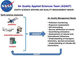
Observing Systems Satellite Surf. Obs. Population Model Emission Atmospheric Composition Enforcing Standards Informing the Public Hemispheric Transport Science & Education Regulatory Analysis Real-time Service Policy Assessment Air Quality & Health Applications
GEOSS Air Quality Community of Practice(GEO CoP) GEO Perspective: • Need conduit for communication with the AQ community Practitioner Perspective: • Forum for sharing experiences, information…..++ CoP Motto (by RBH): Connect and Enable (Divide and Conquer)
How you can contribute and benefit Community Building • Share your interests and project contributions (like this meeting) • Use ESIP for advancing your project objectives (e.g., ‘built-in’ testers, users…) • Help define the GEOSS GCI and/or Community of Practice Enhance the Information Infrastructure • Become a ‘node’ on the air quality interoperability network • Learn best practices in implementing standards for sharing your project data and tools • Participate in (and influence) the GEOSS Architecture Implementation Pilot • Use the AQ Community Information Architecture (register your services in GEOSS, find information resources useful for your project) • Participate in the development of air quality information networks Collaborate on AQ Science and Research Projects
DataFed Application/Tech Infusion: Hemispheric Transport of Air Pollutants (HTAP)HTAP Data Network
Interested in participating in the HTAP Network? Want to Help Building Network? Participate in the AQ Community of Practice Have AQ Info Need? Make your need be known to CoP Have Data or Model Register them in the HTAP Catalog
Loosely Coupled Data Access through Standard Protocols Obs. & Models Decision Support System Control Std. Interface Std. Interface Data Reports Data Sharing Gen. Processing Domain Processing Reporting The next three slides describe the key technologies used in the creation of an adaptable and responsive air quality information system. OGC data access protocols and standard formats facilitate loose coupling between data on the internet and processing services. For air quality, the Web Coverage Service (WCS), provides a universal simple query language for requesting data as where, when, what. That is: geographic (3D bounding box), time range and parameter. The Web Map Service (WMS) and Web Feature Service (WFS) are also useful. The use of standard data physical data formats and naming conventions elevates the syntactic and semantic interoperability. Within DataFed all data access services are implemented as WCS or WMS and optionally WFS. General format adapter components permit data request in a variety of standard formats. Server GetCapabilities Client Std. Interface Std. Interface Capabilities, ‘Profile’ Back End Where? When? What? Which Format? Front End GetData Data T1 T2
GEOSS Framework Air Quality Info System Users (Classes) Links (Types) Info (Flow) User/Actor Class Data Mgr Proc/Med ‘Informer’ Dec Maker HTAP Science Data Manager Atm. Science Assessors LRTP Lead Taskforce Foreign Ministers Except Event Portal Manager Sate Agency Analyst Fed. Agency Regulator EPA Reg. Dec. Maker GEOSS Core Real Time Automatic Data Forecaster Analyst Media Public, Private Public Individual