Download
1 / 50
500 likes | 506 Views
Earth’s Interior. Earth’s Structure. Objectives: 1. Describe the science of geology 2. Describe the main layers of Earth’s interior. Geology. Definition: geology is the study of planet Earth, including its composition and structure

E N D
Earth’s Structure • Objectives: • 1. Describe the science of geology • 2. Describe the main layers of Earth’s interior
Geology • Definition: geology is the study of planet Earth, including its composition and structure • Definition: uniformitarianism is the idea that the geologic processes that operate today also operated in the past
Earth’s Interior • Earth can be divided into 3 main layers: the crust, the mantle and the core • Definition: the crust is the rocky outer layer of Earth • We walk on the continental crust which contains silicates • Definition: silicates are rocks made up of silicon & oxygen and often contain aluminum, iron or calcium • Aluminum is the most abundant element in Earth’s crust
Two types of crust exist: continental crust and oceanic crust • Definition: continental crust is the rocks that make up the continents • The rocks are less dense like granite • Continental crust ranges in thickness from 8 to 75 kilometers • Definition: oceanic crust is the rocks that make up the ocean bottom • Oceanic crust ranges about 7 kilometers thick & is thin and dense compared to continental crust
Definition: the mantle is the layer of Earth beneath the crust • The mantle is thick & made of hot, solid rock • It is about 2850 kilometers thick • The mantle has 3 layers: the lithosphere, asthenosphere, and mesosphere • The lithosphere is about 100 km thick & consists of cool rigid rock including the uppermost part of the mantle and the crust
The asthenosphere is located beneath the lithosphere • Is is weaker, softer rock thought to have the consistency of bubble gum • It is believed to flow slowly • The mesosphere is located underneath the asthenosphere • The mesosphere consists of stiffer rock • The mesosphere extends all the way down to the upper surface of Earth’s core
The third and final main layer of Earth is called the core • There are 2 parts to the core: the outer core and the inner core • Scientists think that the core consists of metals, mostly nickel and some lighter elements • There is enormous pressure at Earth’s core and the temperature is thought to be about 5500°C (nearly equal to sun’s surface) • In the outer core, high temperatures keep the metal liquid
Because of Earth’s rotation, the flowing iron in the outer core is believed to create Earth’s magnetic field • The temperature at the inner core is also very high but the pressure is greater than the pressure on the outer core • Therefore, the inner core is believed to be solid
Minerals • Objectives: • 1. Distinguish between rocks and minerals • 2. Explain several properties used to identify minerals
Rocks and Minerals • Definition: a rock is a solid combination of minerals or mineral materials • Definition: a mineral is a naturally occurring inorganic solid with a crystal structure and a characteristic chemical composition • Definition: inorganic solids are products of nonliving things • Minerals are the building blocks of rocks
Properties of Minerals • Some properties of minerals include: crystal structure, color, streak, luster, density, hardness and fracture • Crystal structure means that the atoms have a specific geometric shape • Some minerals have a characteristic color • Streak is the color of the mineral’s powder
Luster is a measure of how shiny the mineral is & it is the way its surface reflects the light • Density depends on the unique chemical composition of the mineral & it is a unique physical property of all substances • Density is mass divided by volume • Hardness is the resistance of the mineral to scratching • Hardness of minerals is measured by Mohs Hardness Scale which runs from 1 (softest) to 10 (hardest) • Talc or chalk is 1 and diamonds are 10
Fracture is how the mineral breaks • Some minerals split along a geometric line or plane • Some minerals have other properties such as solubility (ability to dissolve) in certain substances, florescence, electrical charge when heated, cooled or subjected to pressure or ability to refract light
Rocks and the Rock Cycle • Objectives: • 1. Classify rocks as igneous, sedimentary or metamorphic • 2. Explain how different types of rocks form • 3. Describe the processes by which rocks continually change from one type to another in the rock cycle
Classifying Rocks • Rocks are classified into 3 major groups: igneous, sedimentary and metamorphic • The classification is based on how they form • Definition: magma is a mixture of molten rock and gases which forms underground • Definition: lava is magma that flows out of volcanoes • Igneous rock forms from magma • Quartz is an igneous mineral but can be found in the other rock types as a mineral
There are 2 types of igneous rock: intrusive and extrusive • Intrusive igneous rock forms underground slowly from hardened magma • Extrusive igneous rock forms faster at Earth’s surface • Examples of intrusive igneous rock include gabbro and granite • An extrusive rock is basalt • Some other kinds of igneous rocks include: Obsidian (extrusive volcanic glass), Pumice, & Rhyolite
Definition: sediment consists of small pieces of material that comes from rocks or living organisms • The basic mechanism of formation has to do with pressure and the presence of water, weathering and erosion • as more and more sediments build up over time, the deeper layers become compressed & squeezed with dissolved minerals (usually in water) seeping into the spaces creating the cement that holds the layers of sediment together • Geologists classify sedimentary rocks into 3 groups according to how they form: clastic rocks, chemical rocks and organic rocks
Definition: clastic rocks are sedimentary rocks formed from broken fragments of other rocks • Clastic rocks are held together by cement • An example is conglomerate • Definition: chemical rock is sedimentary rock that form when minerals precipitate out of solution • An example is calcium carbonate, limestone or shale • Definition: organic rocks form from once living organisms such as dead coral, clams, and mussels • An example is the White Cliffs of Dover (England) composed of chalk from dead sea organisms • Sandstone is also a sedimentary rock • The picture that follows shows some common sedimentary rocks
Definition: metamorphic rock is rock that has been changed by temperature, pressure or reactions with hot water • Most metamorphic rocks form under high temperatures and pressure deep underground • Slate, schist and gneiss are metamorphic rocks that can be formed from the sedimentary rock shale after temperature & pressure • Marble and Quartzite are also metamorphic rocks
The Rock Cycle • Definition: the rock cycle is a series of processes in which rocks continuously change from one type to another • In the rock cycle, forces within Earth and at the surface cause rocks to change form • Igneous rock forces include: magma, melting and cooling • Sedimentary rock forces include: weathering, erosion, compacting and cementation • Metamorphic rock forces include: heat and pressure
Plate Tectonics • Objectives: • 1. Explain the hypothesis of continental drift • 2. Relate how the theory of plate tectonics explains sea-floor spreading, subduction and the formation of mountains • 3. Explain the mechanisms of plate movement
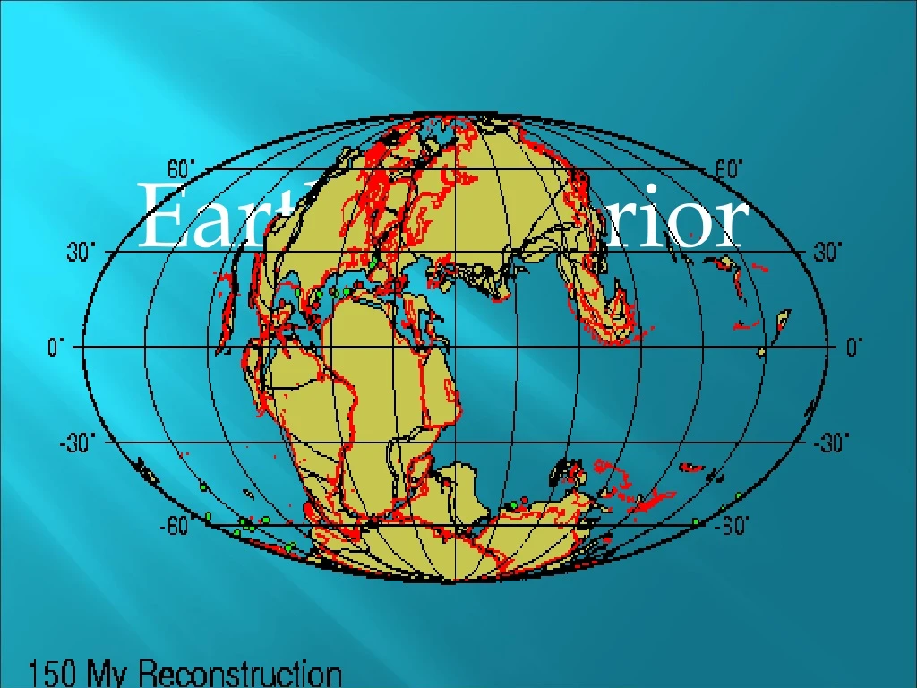
Continental Drift • Definition: plate tectonics is the theory that pieces of Earth’s lithosphere, called plates, move about slowly on top of the asthenosphere • The theory of plate tectonics explains the formation and movement of Earth’s plates • In 1912, a German scientist named Alfred Wegner proposed the theory of continental drift • Wegner hypothesized that the continents were once joined in a single supercontinent (called Pangaea) which then broke into pieces and moved apart
Sea-floor Spreading, Subduction & Mountains • Wegner’s hypothesis and new evidence led geologists to propose the theory of plate tectonics • In the mid 1900s scientists mapped a chain of ocean mountain called the mid-ocean ridge • While mapping the ridge they also found a deep valley running the length of the crest • A geologist named Harry Hess proposed the theory of sea-floor spreading to explain this
Definition: sea-floor spreading is the process by which new oceanic crust is created at the mid-ocean ridges as older crust moves away • The ridge is a huge crack where magma is pulled upward • Definition: subduction is the process by which oceanic plates sink into the magma of the mantle creating a trench • As sea-floor spreading occurs, old oceanic plates sink into subduction zones • Definition: a trench is a depression in the ocean floor caused by the plate sinking into the subduction zone
Sea-floor spreading creates new oceanic crust at mid-ocean ridges • Subduction destroys old oceanic crust at subduction zones • Patterns of parallel magnetic stripes in the rocks were identical and found on both sides of the ridge • The stripes exist because Earth has reversed its magnetic field several times in the past • The stripes indicate that new ocean floor was added to both sides of the ridge about roughly the same time
The Theory of Plate Tectonics & Plate Movement • Sea-floor spreading provided evidence that pieces of Earth’s crust move • The plate tectonics theory says that Earth’s plates are constantly moving independent of each other • Each plate moves at a different rate and direction • Plate motions are the visible part of the process of mantle convection • The picture that follows begins today and goes back millions of years to visualize Pangaea
Definition: convection is the transfer of heat energy when particles of a fluid move from one place to another • Convection currents usually exist in circular patterns • The heat that drives plate tectonic convection in the mantle comes from the decay of radioactive isotopes in the mantle & crust, and also from the gradual cooling of the interior of Earth • Earth was hot when it was formed
Plate Movement & Boundaries • There are about a dozen major tectonic plates • Most plates contain both continental & oceanic crust • There are 3 types of plate boundaries: divergent boundaries, convergent boundaries & transform boundaries • The plates move slowly, from 0.1 cm – 10 cm per year
Divergent plates move away from each other • The mid-ocean ridge is a major divergent boundary • When plates move apart, magma from the mantle rises, fills the gap, then forms new rock • Convergent plates move toward each other • Most convergent boundaries occur at subduction zones where more dense oceanic crust dives underneath continental crust, slipping into the magma, melting and destroying rock • At transform boundaries, the plates slide past each other in opposite directions • Rock is neither created nor destroyed • The San Andreas fault of which we are a part, is a transform boundary
Mountains form along plate boundaries • At convergent boundaries where crust has the same density, neither plate is subducted during the collision • The crust buckles, folds, thickens and pushes up tall mountains • Occasionally this happens between oceanic & continental crust, but usually between continental crust • At divergent boundaries, the mid-ocean ridge forms a long chain of mountains on the sea floor • No mountains are formed at transform boundaries
Earthquakes • Objectives: • 1. Describe the causes and effects of stress in Earth’s crust • 2. Explain why earthquakes occur and how their energy is • 3. Explain how earthquakes are measured and how earthquake data is used to learn about Earth’s interior
Stress in Earth’s Crust • Definition: an earthquake is movement of Earth’s lithosphere that occurs when rock in the lithosphere suddenly shift, releasing stored energy • Definition: seismic waves are energy released during the earthquake and carried by vibrations • Definition: a tsunami is a large sea wave generated by an underwater earthquake, volcano or landslide
Definition: stress is a force that squeezes rocks together, stretches or pulls them apart, or pushes them in different directions • As tectonic plates move, they cause stress in the crust which produces faults and folds • Definition: a fault is break in the mass of rock along which movement occurs • Many faults along plate boundaries • Definition: a fold is a bend in the layers of rock • Folds form where rocks are squeezed together but do not break • They can be seen in rock layers that make up some mountain ranges • The pictures that follow show folded sedimentary rock layers & other folded rock
Why Earthquakes Occur • Earthquakes occur because stress forces have exceeded the strength of the rock • As the rocks break and move, potential energy is transformed into kinetic energy in the form of seismic waves • Earthquakes produce 3 types of waves: P waves, S waves and surface waves • P waves are primary waves • They are longitudinal waves similar to sound waves • P waves compress and expand the ground like an accordion
S waves are secondary waves • They are transverse waves like light or electromagnetic radiation • Surface waves develop when seismic waves reach Earth’s surface • Surface waves move more slowly than P and S waves, but produce larger ground movements and greater damage
How Earthquakes are Measured • Definition: focus is the place underground where the rock broke & the earthquake started • Definition: epicenter is the place above ground directly above the focus • Scientists use their equipment to gather information on where the epicenter and focus are & to estimate the size of the earthquake
Geologists record seismic waves using seismographs to measure & pinpoint the epicenter • Definition: a seismograph is a device that detects and records seismic waves • The Richter scale for measurement is no longer used by geologists
The moment magnitude scale gives a measure of the amount of energy released • It is the most useful of the scales currently used • The modified Mercalli Scale ranges from 1 to 12 and is based on observations of the intensity of ground shaking and damage in the areas affected by an earthquake • An earthquake of 7 knocks over chimneys, while 12 is total destruction of a city and nearby towns • Most earthquakes are concentrated along plate boundaries, where many faults are found
Volcanoes • Objectives: • 1. Describe the internal structure of a volcano and how volcanoes form • 2. Relate the type of volcanic eruption to the characteristics of magma • 3. Describe the different types of volcanoes and where they are located • 4. Describe several types of igneous features and how they are formed
Internal Structure • Under certain conditions, small amounts of mantle rock can melt, forming liquid magma • The magma rises upward through the crust, erupting at the surface as a volcano • Before eruption, magma collects in a pocket called a magma chamber • The magma rises to the surface in a vertical channel called a pipe • The magma escapes on the surface at the vent • A large central vent in most volcanoes is a bowl-shaped pit called a crater
Eruption • After eruption, the magma chamber and main vent may be empty of magma, creating a hollow shell • If the shell collapses inward, it creates a depression called a caldera, located at the top of the volcano • Volcanoes erupt explosively or quietly depending on the characteristics of the magma • Recall that viscosity is resistance to flow • Magma with high viscosity erupts explosively • The picture is of a caldera of a volcano in Hawaii
Types and Locations • Most volcanoes occur along plate boundaries • A few are located at hot spots in the crust • The volcanoes at plate boundaries are associated with subduction zones • Definition: a hot spot is a region where hot rock extends from deep within the mantle to the surface • Hawaii is built on active hot spot volcanoes
There are 3 major types of volcanoes • They are: shield volcanoes, cinder cones, and composite volcanoes • A quiet eruption of low viscosity produces a wide, flat shield volcano • An ash and cinder eruption produces a steep-sided cinder cone volcano • Lava and ash explosive eruptions form composite volcanoes • Mount Saint Helens is a composite volcano
Igneous Features • Magma forms igneous features such as batholiths, sills, dikes and volcanic necks • Definition: a batholith is the largest type of intrusive igneous rock mass • We live in the Sierra Nevada Batholith & it is the the core of our mountain range which was born out of volcanoes • The picture is of the Sierra Nevada Batholith
Definition: a sill is magma that has squeezed into a crack that is parallel to the existing rock and hardened • Definition: a dike is hardened magma that has formed in a crack that cuts across rock layers • Definition: volcanic rock is magma that has hardened in a volcano’s pipe • The largest lava flows come from clusters of long thin cracks in Earth’s crust (not from volcanoes) • Definition: a plateau is lava that has spread and created a high level area