Download

1 / 24
240 likes | 244 Views
IGIC Data Sharing Committee. Co Chairs:. Steve Hook, GISP Noble County GIS Manager 260-636-1293 Ext. 5201 shook@nobleco.us Shaun Scholer Wayne County/Richmond 765-973-9385 sscholer@co.wayne.in.us. What is the IGIC Data Sharing Committee. Mission:

E N D
IGIC Data Sharing Committee Co Chairs: Steve Hook, GISP Noble County GIS Manager 260-636-1293 Ext. 5201 shook@nobleco.us Shaun Scholer Wayne County/Richmond 765-973-9385 sscholer@co.wayne.in.us
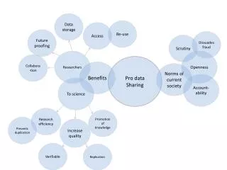
What is the IGIC Data Sharing Committee Mission: Identify and prioritize options for data sharing in Indiana Long Term Goals: Develop a data sharing implementation plan
Other Goals 1. Address policy issues and partnership agreements regarding data access and distribution. 2. Support the development and evolution of new data standards, models and methods to support data sharing and stewardship efforts across Indiana. 3. Address geospatial data security and data exchange issues. 4. Draft IGIC’s biennial Data Integration Plan published for the State Geographic Information Officer.
What’s Been Done Historically • Statewide Data Integration Plan • Discussion of pros and cons of data sharing Agreement with the State of Indiana • Reasons to share • Reasons not to share
IndianaMap Data Sharing Initiative The IndianaMap County Data Sharing Initiative All 92 Indiana Counties are participating, consisting of… 4,870 Government Boundaries 603,132 Street Centerlines 3,630,775 Parcels 3,191,230 Address Points
What’s Been Done Historically Encouraging people to update their GIS information in Ramona now known as GIS Inventory—initiative of National States Geographic Information Council (NSGIC)
What’s Been Done Historically Determine data standards regarding boundaries and addresses – creation of County Boundary Workgroup Assist with the distribution of LIDAR data for OpenTopography.org
What’s Been Done Historically Document GeoServer installation and configuration
What’s Been Done Historically Discussion on IC 36-1-8.5-2 Restricted Addresses Indiana Code changing language from “May” to “Shall.” Prevents disclosure of a person’s home address displayed on a public property data base web site for the following covered persons—judge, law enforcement officer, victim of domestic violence and a public official. Provides ability for a unit to charge a covered person a reasonable fee to make a written request.
What’s Been Done Historically Draft version of the 2016 IndianaMap County Data Sharing Initiative— Fact Sheet of Attribute Request Review of House Bill 1273, requesting… “…the geographic information system characteristic of each parcel…” 3. Support State GIO’s round 2 of the State Data Sharing
3 - year cycle, PAID FOR by the Indiana Office of the USDA Natural Resource Conservation Service (NRCS), Administered by the United States Geological Survey’s (USGS) 3D Elevation Program (3DEP) GPSE Contract Base Products .7 - meter pulse spacing LiDAR 2.5 foot hydro-flattened DEM Available Buy-up Options Enhanced Point Cloud Classification 2D/2.5D/3D Building outline extraction Photogrammetric & GIS Services [NEW] Statewide Lidar
Data Sharing Committee Goals Continued support of the IGIC Data Integration Plan Continue development of the UOI (Utility of Investment) Help promote the availability, quality, currency and use of Authoritative IndianaMap Data. Support the GIO's current data sharing & harvest efforts.
Enhanced County Data Sharing Initiative • Adding Value to County Data Sharing Initiative • Adding attributes to harvested centerline, point address, and parcel layers to support statewide geoprocessing, geocoding and routing applications [INDOT, NG9-1-1, ISP, US Census & more] • Quality Reporting of harvested data back to the Counties [with attribute additions and changes] . • Creating seamless statewide datasets matching at the new GIS County Boundary Layer .
Enhanced County Data Sharing Initiative • Load data harvest into Esri Local Government Data Model • Integrate DLGF Property Data into geodatabase
Data Sharing Committee Goals • Support NSGIC initiatives • Participate in GIS Inventory makeover & Indiana updates • Participate in GIS Benefits and Stories - Public Documents • Participate in Survey on State-Local Data Layer Interdependencies • Participate in Open Civic Boundaries Best Practice
IGIC Responsibilities • As per Indiana Code 4-23-7.3 (passed in 2007), IGIC is responsible for: • Coordinating with the Indiana Geographic Information Officer • Recommending the state's GIS data standards for adoption • Recommending a statewide data integration plan for adoption • Establishing the Indiana Board on Geographic Names
Why Do We Collaborate? • WE UNDERSTAND THE VALUE OF THIS DATA TO EVERYONE IN INDIANA! • WE UNDERSTAND THAT THE RETURN ON INVESTMENT FROM THESE STATEWIDE INITIATIVES IS SIGNIFICANT! • WE UNDERSTAND THAT NO SINGLE ORGANIZATION HAS THE RESOURCES TO FUND THESE STATEWIDE PROJECTS, SO PARTNERSHIPS ARE CRITICAL TO THEIR SUCCESS. • CREDIT FOR THESE ACCOMPLISMENTS GOES TO EACH ONE OF US, and to our strong… • LOCAL <–> STATE <–> FEDERALPARTNERSHIPS
Federal Government State Government Private Sector Cities & Towns Counties Universities Hoosier Data Sharing & Hospitality Project Partnerships 22
Join the Data Sharing Committee IGIC Data Sharing Committee Feel free to contact us! Steve Hook, GISP Noble County GIS Manager 260-636-1293 Ext. 5201 shook@nobleco.org Shaun Scholer Wayne County/Richmond 765-973-9385 sscholer@co.wayne.in.us