Download
1 / 27
290 likes | 527 Views
Spatial Cloud Computing. Chaowei Phil Yang, Co- Director NASA/GMU Joint Center of Intelligent Spatial Computing for Water/Energy Sciences Associate Professor, Geography and GeoInformation Science George Mason Univ., Fairfax, VA, 22030-4444 http://cisc.gmu.edu/ http://cpgis.gmu.edu/homepage/.

E N D
Spatial Cloud Computing Chaowei Phil Yang, Co-Director NASA/GMU Joint Center of Intelligent Spatial Computing for Water/Energy Sciences Associate Professor, Geography and GeoInformation Science George Mason Univ., Fairfax, VA, 22030-4444 http://cisc.gmu.edu/ http://cpgis.gmu.edu/homepage/
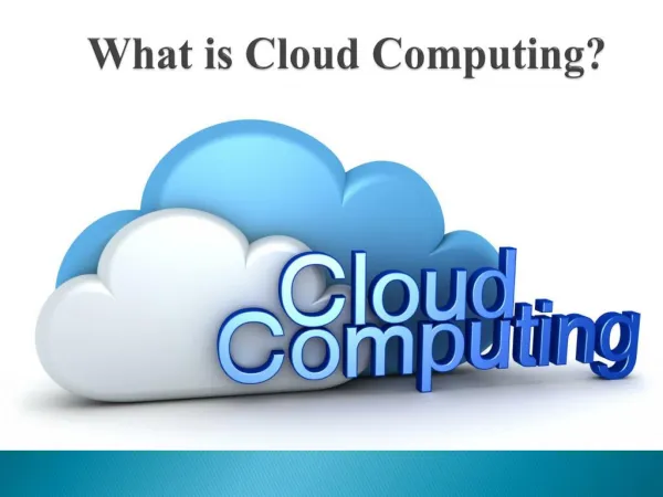
Agenda • Concept • Why Cloud Computing? • Cloud Computing • Characteristics of Cloud Computing • Spatial Cloud Computing • Examples • GEOSS Clearinghouse • Dust Storm Forecasting & Visualization • How to implement • Research directions
Why Cloud Computing? • What if we can • Integrate all geospatial data, information, knowledge, processing in a few minutes • Generate and send the right information in real time to the people including decision makers, first responders, victims • This dream requires a computing platform that • can be ready in a few minutes • can reach out to all people needed • only cost for the amount of computing used • won’t cost to maintain after the emergency response • This is exactly what cloud computing can provide
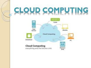
Cloud Computing Cloud computing is a model for enabling convenient, on-demand network access to a shared pool of configurable computing resources (e.g., networks, servers, storage, applications, and services) that can be rapidly provisioned and released with minimal management effort or service provider interaction. This cloud model promotes availability and is composed of five essential characteristics, three service models, and four deployment models. NIST 2010
Cloud Computing • Five essential characteristics, which differentiate cloud computing from grid computing and other distributed computing paradigms: • On-demand self-service. provision computing capabilities as needed automatically. • Broad network access. available over the network and accessed through standard mechanisms. • Resource pooling. computing resources are pooled with location independence • Rapid elasticity. Capabilities can be rapidly and elastically provisioned. • Measured Service. automatically control and optimize resource NIST 2010
Cloud Computing • Three service models • Software as a Service (SaaSCloud), such as gmail • Platform as a Service (PaaS), such as MS Azure • Infrastructure as a Service (IaaS), such as Amazon EC2 • 4. Data as a Service (DaaS) NIST 2010
Geospatial Science Information Workflow IT Characteristics: Data Intensity Computing Intensity Concurrent Access Intensity, and Spatiotemporal Intensity
Spatial Cloud Computing Refers to the distributed computing paradigm that • Enables the geospatial science discoveries, emergency responses, education, other societal benefits • Is optimized by spatiotemporal principles. Yang C., Goodchild M., Huang Q., NebertD., Raskin R., Xu Y., Bambacus M., Fay D., 2011. Spatial Cloud Computing: How can geospatial science use and help to shape cloud computing? International Journal on Digital Earth. 4, 305-329.
Agenda • Concept • Cloud Computing • Characteristics of CC and SCC • Spatial Cloud Computing • Examples • GEOSS Clearinghouse • Dust Storm Forecasting & Visualization • How to implement • Research Directions
Natural Hazards: Dust Storms Forecasting & Visualization • Enabling Computing Technologies • Cloud Computing as an advanced cloud computing platform to support simulation and forecasting. • Cloud DB as a data management tool for large volumetric data. • 4D/5D Vis Tool to render the data. • Objectives • Provide timely forecasting of dust storm for public health emergency responses • Provide an intuitive interface for decision makers
GEOSS Clearinghouse • Objectives • Share Global Earth Observation Data Among 140+ Countries to Address Global Challenges of Natural Hazards and Emergency Responses • Support Global End Users to Discover, Access, and Utilize EO Data • Provide Responses to End Users in Seconds • Advanced Computing Technologies • Cloud Computing (EC2 & Azure) Responds to Spike Massive Concurrent End Users • Cloud DB (SQLAzure) Manages Millions to Billions of Metadata Records • WebGIS & 5D Vis Tools to Visualizes EO Data
Agenda • Concept • Cloud Computing • Characteristics of CC • Spatial Cloud Computing • Examples • GEOSS Clearinghouse • Dust Storm Forecasting & Visualization • How to implement • Research Directions
Agenda • Concept • Cloud Computing • Characteristics of CC • Spatial Cloud Computing • Examples • GEOSS Clearinghouse • Dust Storm Forecasting & Visualization • How to implement • Research Directions
Potential Research Directions Spatiotemporal principle, thinking, and comptuing Implement important complex geospatial science and applications for best practice Supporting the SCC characteristics Security Citizen and social science issues: Trustworthy, Privacy, Ethical, etc. Many other (scholar) aspects of geospatial sciences
Spatial Cloud Computing Special Issue • 4th Issue of 5th Volume of International Journal on Digital Earth, (New Journal, SCI Impact Factor 1.453) • Received 25 extended abstract from field leaders around the world • Selected 13 to submit full paper for review • Look for reviewers • Please email cyang3@gmu.edu • state your interests in reviewing the SCC full papers • a one page bio of you focus on cloud computing and geospatial sciences
References Definition paper Yang, C., Goodchild M., Huang Q., Nebert D., Raskin R., Xu Y., Bambacus M., Fay D., 2011a, Spatial Cloud Computing: How could geospatial sciences use and help to shape cloud computing, International Journal on Digital Earth. Review & Overview Foster, I., Zhao, Y., Raicu, Y., Lu, S., 2008. Cloud Computing and Grid Computing 360-Degree Compared, In: Grid Computing Environments Workshop, GCE 2008. IEEE, Los Alamitos.2. Yang, C., Raskin, R., Goodchild, M.F., and Gahegan, M., 2010, Geospatial Cyberinfrastructure: Past, Present and Future, Computers, Environment, and Urban Systems, 34(4):264-277. Spatiotemporal data modeling M.F. Goodchild, M. Yuan, and T.J. Cova (2007) Towards a general theory of geographic representation in GIS. International Journal of Geographical Information Science 21(3): 239–260. (Open Access) Rey, S. J., and M. V. Janikas. 2006. STARS: Space-Time Analysis of Regional Systems. Geographical Analysis, 38 (1): 67–86. Systematic research Armbrust, M, Fox, A., Griffith R., Joseph A., Katz, R. and etc, 2009. Above the Cloud: A Berkeley View of Cloud Computing, Technical Report No. UCB/EECS-2009-28. (Open Access) Wang S. and Armstrong M., 2009. A theoretical approach to the use of cyberinfrastructure in geographical analysis, International Journal of Geographical Information Science 23(2), 169 – 193. (Open Access) Yang C., Wu H., Li Z., Huang Q., Li J., 2011, Spatial Computing: Utilizing Spatial Principles to Optimize Distributed Computing for Enabling Physical Science Discoveries, Proceedings of National Academy of Sciences, doi: 10.1073/pnas.0909315108. (Open Access) http://www.pnas.org/content/early/2011/03/21/0909315108.full.pdf Examplar applications Wang, S., and Liu, Y. 2009. TeraGrid GIScience Gateway: Bridging Cyberinfrastructure and GIScience. International Journal of Geographical Information Science, 23 (5): 631-656. Evangelinos C., Hill C., 2008. Cloud Computing for parallel Scientific HPC Applications: Feasibility of running Coupled Atmosphere-Ocean Climate Models on Amazon’s EC2, CCA-08 October 22–23, 2008.