Download
1 / 17
170 likes | 306 Views
a. FY12-13 GIMPAP Project Proposal Title Page version 04 August 2011. Title : Advancing GOES Cloud and Surface Irradiance Products for Applications to Short-Term Solar Energy Forecasting Status : New project Duration : 2 years Project Leads:

E N D
a. FY12-13 GIMPAP Project Proposal Title Pageversion 04 August 2011 Title:Advancing GOES Cloud and Surface Irradiance Products for Applications to Short-Term Solar Energy Forecasting Status: New project Duration: 2 years Project Leads: Dr. Steven Miller, CSU/CIRA, (miller@cira.colostate.edu) Dr. Matt Rogers, CSU/CIRA, (rogers@cira.colostate.edu) Other Participants: Dr. Andrew Heidinger, NOAA/NESDIS-STAR Dr. Istvan Laszlo, NOAA/NESDIS-STAR Dr. Stan Benjamin, NOAA/OAR-ESRL Dr. Manajit Sengupta, NREL Prof. Jan Kleissl, UC San Diego Mr. J. Adam Kankiewics, WindLogics
b. Project Summary New capabilities, based on GOES-derived cloud and surface irradiance products, to advance the current state of the art in short-term (0-3 hr) solar energy prediction: Develop physically-based satellite/model fusion algorithms for projecting GOES-derived information into the future, accounting for Sun/satellite geometry Predict the time series of surface irradiance at selectable locations within the GOES field of regard Validate against nationally-distributed NOAA SURFaceRADiation (SURFRAD) network in addition to other well-calibrated station observations maintained by our partners Evaluate performance against NWP-based short-term forecasts (emphasizing the High Resolution Rapid Refresh [HRRR] model) for various flow patterns (meteorological regimes) and cloud morphologies
c. Motivation / Justification • NOAA’s Next Generation Strategic Plan (Dec 2010) • ‘The capacity to increase renewable energy generation, which is fundamental to economic security and sustainable development,is based in part on the ability to predict … cloud patterns.’ • ‘Burgeoning renewable energy industries need more accurate resource assessments with better observations tailored to sources such as solar irradiance … and cloud cover measurement.’ • NOAA/DoE Memorandum of Understanding on Weather-Dependent and Oceanic Renewable Energy Resources (Jan 2011) • Collaborative partnership to enhance accuracy, precision and completeness of resource information for effective deployment, safe/reliable/sustainable operation and maintenance, and efficient use of technology and infrastructure. • Advancement of solar energy across a wide range of spatial and temporal scales to achieve economic and reliable use at utility scales, requiring improvements to relevant observations and prediction schemes. • Opportunity—Harvesting the Low-Hanging Fruit • Significant investments in NOAA satellite observing systems are currently under-utilized for solar energy forecasting, particularly in terms of GOES-derived cloud parameters. • Current state of the art is based largely on empirical relationships • Builds on momentum from FY10-11 GIMPAP Solar proposal, new application to the improved Pathfinder Atmospheres Extended (PATMOS-x) operational GOES cloud product suite • Partnership–Convergent Interests Promote Leveraging • Aunique and diverse collaboration that partners CSU/CIRA with leaders from NOAA’s satellite remote sensing (NESDIS) and NWP communities (ESRL), the DoE (NREL), otheracademia (UCSD; Kleissl Solar Resource Assessment and Forecasting Lab), and industry (WindLogics) for the common purpose of improving 0-3 hr cloud shadow forecasting.
d. Methodology (1 of 4) Imagine we are viewing this cloud from the satellite Shadow X 50 km PV Array • Account for both parallax and solar geometry, given knowledge of cloud top height and the surface elevation • Use NWP wind fields (which assimilate cloud motion vector information) to steer clouds in complex sheer environments. • The proposed work will include automated geometry corrections and track cloud patterns in 4 dimensions . 4
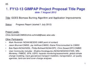
d. Methodology (2 of 4) CSU Station Observations GOES-11: Predicted Cloud Movement 2100 UTC CSU Station WY Irradiance [W/m2] CO Sunset Sunrise NM Observed ‘ramp’ in solar energy at CSU Station occurred during a break between two convective clouds… High Clouds Mid-Troposphere Low Clouds 100 1000 Cloud Top Pressure (mb) The proposed work will improve this advection capability through cloud grouping and steering level determinations based on NOAA/NESDIS PATMOS-x GOES-derived cloud products.
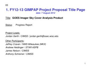
d. Methodology (3 of 4) Visible Reflectance (%) Retrieved Cloud Fraction UT NV False Cloud Desert Rock Station Surface Brightening CA AZ Surface Brightening False Cloud 0 60 0 1.0 (%) Fraction Increased surface reflectance (left panel) leads to anomalous cloud fractions over deserts (right panel) of operational GOES cloud product—an artifact of the ‘hot spot’, a.k.a. ‘opposition surge’ effect.
d. Methodology (4 of 4) Sun/Satellite Geometry Observations at Desert Rock, NV Surface Obs are Clear… …but GOES retrievals suggest cloudy. Sun Directly Behind Satellite Hotspot Time Quality-control with an eye toward solar energy applications will improve the utility of operational NOAA satellite products to both short term forecasting and resource assessment.
e. Expected Outcomes • New, physically based methodologies and tools for forecasting the time series of solar irradiance • Builds on previous GIMPAP project with new GOES products (PATMOS-x), improved advection methods, and expanded validation opportunities • A critical assessment of HRRR forecast performance in comparison to satellite methods • - Skill transitions from satellite-based to model-based cloud prediction • - Analysis as a function of season, region, and meteorological regimes • - Potential for HRRR/GOES product fusion work • Tangible results addressing key elements of NOAA’s Strategic Plan and the NOAA/DoE MOU • - Targets improved cloud prediction at time scales where models have difficulty with deterministic placement of cloud features • - Better use of NOAA/NESDIS satellite technology and infrastructure • - Improves coupling of cloud retrieval and surface irradiance model components for accurate long-term records (resource assessment)
e. Possible Path to Operations • Through NOAA/DoEMOU paradigmof expanded use: • New pathways for demonstrations and operational transition under MOU, including non-governmental and international partners • DoE/NREL has numerous well-established partnerships with industry, and can serve as a transition partner here • Through direct connections to operational users: • WindLogics offers opportunities to link research directly to utilities for demonstrating GOES tools in the context of actual power production / scheduling • UCSD & CSU are partnering with industry to host on-site photovoltaic arrays • Through collaboration with modeling community: • NOAA’s HRRR model represents the future of operational mesoscaleforecasting, and includes a focus on renewable energy parameters • We will couple directly to HRRR via satellite-based cloud trajectories Solar energy is on the threshold of competing viably with coal in global markets. The proposed research asserts NOAA’s role as a strong partner agency in this area of National priority.
f. Milestones • FY12 Milestones • Develop cloud grouping & trajectory logic on PATMOS-X products (applied to GOES-W and GOES-E) and GFS/HRRR winds • Evaluate coupling between PATMOS-X and SASRAB irradiance software for calculation of solar irradiance at the surface • Begin assessing the performance of GOES cloud trajectory vs. NWP (HRRR) forecast skill under different conditions • FY13 Milestones • Continue validation experiments at SURFRAD sites, as well as in coordination with NREL, CSU, UCSD, and WindLogics partners • Produce automated software for computing surface irradiance component (total/direct/diffuse) time series at arbitrary locations • Publish findings and package/document all software and datasets
g. Spending Plan FY12 • FY12 $65,000 Total Project Budget • Grants to CIRA $ 65,000 • ~40% FTE - $62K • Travel - $3K • Publication charge - $0 • Federal Publication Charges - $0 • Federal Equipment - $0 • Transfers to Federal Travel - $0 • Other agencies - $0 • Other - $0
g. Spending Plan FY13 • FY13 $65,000 Total Project Budget • Grants to CIRA $ 65,000 • ~39% FTE - 60K • Travel - $3K • Publication charge - $2K • Federal Publication Charges - $0 • Federal Equipment - $0 • Transfers to Federal Travel - $0 • Other agencies - $0 • Other - $0
Backup: HRRR Evaluation (1 of 2) HRRR/SURFRAD Sioux Falls 10 Apr 2011 (cloudy case) 400 Goal: Develop means of evaluating model forecasts that clarifies the optimal transition between GOES and model-derived insolation forecasts under various conditions. Method: Compare High Resolution Rapid Refresh (HRRR) model against SURFRAD surface network of observations Characterize model forecast performance as a function of both forecast hour and time of day Utilize surface and clear-sky observations to constrain model/observation differences Develop analytical tools to compare model data, surface station data, and GOES-based forecasts concurrently W/m2 200 0 03Z 06Z 09Z 12Z 15Z 18Z 21Z 00Z 03Z HRRR vs SURFRAD – absolute difference Sioux Falls, April 2011 1000 500 0 W/m2 -500 -1000 00Z 03Z 06Z 09Z 12Z 15Z 18Z 21Z 00Z
Backup: HRRR Evaluation (2 of 2) HRRR vs SURFRAD – Sioux Falls, April 2011 Techniques to evaluate model performance. Hone-in on the 0-3 hr forecast range Evaluate model performance vs GOES-based solar forecasts in this same time range using identical analysis for GOES forecast Examine performance for different flow regimes, seasons, and regions. Model over-predicting insolation Model under-predicting insolation (HRRR-SURFRAD) / Clear-sky
Backup: Obs (left) Compared to Predicted (right) 2100 UTC CSU Station CSU Station WY WY 2200 UTC CO CO 2130 UTC NM NM 100 1000 100 1000 Cloud Top Pressure (mb) Cloud Top Pressure (mb) The proposed work will improve this advection capability through cloud grouping and steering level determinations based on NOAA/NESDIS PATMOS-x GOES-derived cloud products.