Download
1 / 1
10 likes | 340 Views
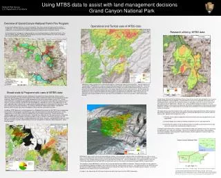
Using MTBS data to assist with land management decisions Grand Canyon National Park National Park Service U.S. Department of the Interior Overview of Grand Canyon National Park’s Fire Program: Operational and Tactical uses of MTBS data:

E N D
Using MTBS data to assist with land management decisions Grand Canyon National Park National Park Service U.S. Department of the Interior Overview of Grand Canyon National Park’s Fire Program: Operational and Tactical uses of MTBS data: Grand Canyon National Park has an active fire program. The current 10 year average annual fire activity is 11,200 acres. The Fire and Aviation program utilizes both prescribed fire (manual/planned ignition) as well as wildland fire use/resource benefit fire (lightning caused) to manage the forests around the Canyon. A critical part of the fire program has been using burn severity data provided by the Monitoring Trends in Burn Severity (MTBS) program. To date, the MTBS program and Grand Canyon National Park staff have mapped burn severity for 35 fires, totaling 90,652 acres. Research utilizing MTBS data: MTBS data is often used by the Fire and Aviation program in the planning stages for prescribed fires. Demonstrated by the example above, MTBS data was used to assist in tactical planning efforts for a 2007 prescribed fire (Roost Rx). During the planning stages, it was determined from the MTBS data that the Poplar fire of 2003 had burned well enough to serve as a control line on the North side of the planned fire, thus greatly reducing the need to install control line. By eliminating miles of control line, the Fire & Aviation program was able to reduce the impacts on the landscape associated with miles of new control line, as well as reduce the overall cost of the project associated with new control line. Only a small amount of control line was actually needed on the far east side of the prescribed burn, which was executed in 2007 and burned as planned. Broad scale & Programmatic uses of MTBS data: The Fire and Aviation program recently completed an Environmental Impact Statement (EIS) to assess alternative activities for a new Fire Management Plan (FMP) and potential effects of these alternatives to park resources. Recent MTBS data was a major component of the assessment of effects for this EIS. The four action alternatives included fire management focused on non-fire treatments, prescribed fire, wildland fire use, and a mix of these activities. MTBS data from prescribed fire, wildland fire use fire, and suppression fire for each vegetation type in the park was used to project the percentage of the landscape that might burn in each burn severity class for each alternative. This analysis allowed the subject-matter experts to predict the potential effects of each alternative to biological, cultural, physical, and social resources. In addition, MTBS data was a critical component in a Biological Assessment for the FMP. Using a combination of permanent monitoring plots and MTBS data, park staff quantified the relationship between burn severity mapping classes and effects to Mexican Spotted Owl critical habitat components. Installing permanent monitoring plots across the entire landscape is limited by time and resources. By determining the relationship between MTBS data and specific monitoring variables (such as change in tree basal area) park staff can better assess large-scale change in habitat components with fewer resources. Compiling MTBS data over time will give managers a greater understanding of how fire management is affecting habitat components across time and space. Grand Canyon National Park and Northern Arizona University are currently working together on a research project utilizing burn severity mapping. A limited amount of research has compared regeneration rates in mixed conifer forests and none has studied the effects of varying burn severities, fire return interval and time since last fire on regeneration. However, fire is a key component of park management, thus the described research is critical to future fire planning. To continue managing forests using natural disturbance processes, managers must understand how fire changes forest conditions to ensure desired regeneration reaches the overstory. The study will focus upon the transition mixed conifer forest type (historically ≥40% and ≤90% ponderosa pine (Pinus ponderosa)) in areas of low and high burn severity with differing fire return intervals and time since last fire. Specific research objectives are to: 1.) Describe current species composition and stand structure while focusing specifically on tree regeneration. 2.) Quantify canopy and surface fuel loading and determine risk of stand replacing fire. 3.) Determine the response of the mixed conifer forests of Grand Canyon National Park to high versus low severity fires and following multiple fire events. In Grand Canyon National Park, managers need to know the effects low and high severity fires are having on regeneration rates across the landscape. Results of this project will yield a better understanding of future forest conditions and management recommendations related to optimal fire rotation lengths in the mixed conifer transition zone. MTBS data is often used in real time for tactical decision making. During the Aspen 2009 fire above, the MTBS data was used in several ways. It was initially used when the Aspen fire started and was being evaluated as to whether or not to allow it to be managed as a resource benefit fire. Park managers did not want the fire to move North of the Neck fire. Using the MTBS data, it was determined that there was sufficient burned ground from the Neck 2007 fire which would serve as fire a barrier, not allowing the Aspen 2009 fire to spread North. The second use of the MTBS data in real time was to estimate how the Aspen 2009 fire would burn. Because the Aspen fire was located in restricted Mexican Spotted Owl habitat, it was critical to minimize the amount of high severity fire. It was determined from the MTBS data that the Vista fire in 2001 had burned well enough such that the second entry effects from the Aspen fire would be greatly reduced. It was then decided to let the Aspen fire burn for resource benefit. As shown in the above map, the final Aspen fire perimeter did in fact stop at the Neck 2007 fire boundary. By: Eric G. Gdula1, Windy A. Bunn2, Anna Marie Higgins3, Dr. Andrea Thode4, and Dr. Kristen Waring5 1-Fire GIS Specialist, Grand Canyon National Park, Grand Canyon, AZ, USA. 2-Fire Ecologist, Grand Canyon National Park, Grand Canyon, AZ, USA. 3-Graduate Student, School of Forestry, Northern Arizona University, USA. 4-Assistant Professor, School of Forestry, Northern Arizona University, Flagstaff AZ, USA. 5-Assistant Professor, School of Forestry, Northern Arizona University, Flagstaff AZ, USA.