Download
1 / 66
680 likes | 835 Views
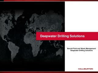
Well Logging (井測法). 授課教師:林再興教授 助教:王志文 2008. 12. 08-15. 井測法的發展及應用. 井測( well logging )是地球物理探勘的方法之一,是把各種探測針放入井孔底部後,在向上拉提的過程中,測定及記錄地層的 電阻 、 自然電位差 、 聲波速度 、 地層放射線強度 等特性。 井測所使用的地球物理原理,主要包含了 電學 、 放射性 、 聲波 等學理。. N. M. A. 電阻井測是量測電極( A )與另一端電極( M 及 N )之間的電位差,由已知的電流計算出地層電阻。.

E N D
Well Logging(井測法) 授課教師:林再興教授 助教:王志文 2008. 12. 08-15
井測法的發展及應用 • 井測(well logging)是地球物理探勘的方法之一,是把各種探測針放入井孔底部後,在向上拉提的過程中,測定及記錄地層的電阻、自然電位差、聲波速度、地層放射線強度等特性。 • 井測所使用的地球物理原理,主要包含了電學、放射性、聲波等學理。
N M A 電阻井測是量測電極(A)與另一端電極(M及N)之間的電位差,由已知的電流計算出地層電阻。 井下電測是在井孔中放入測定地層電阻、自然電位差、聲波速度、地層放射線強度等探測針。
井測法的發展及應用 • Schlumberger 教授從1912年開始構想利用地球物理方法進行地下岩層的偵測工作,於1927年在法國Pechelbronn 油田中首度成功量測到第一口的傳統電阻井測資料,而發明井下電測(或稱「井測」),隨後並把這成功的井測技術推廣到委內瑞拉、印度、蘇聯、美國等國家,從此,利用電學原理的電阻井測開始發展。 • 1931年所發展的自然電位差井測,具有分辨砂岩及頁岩分層區間的能力,1943年發展出地層傾斜電測,可以測出地層的傾角。
井測法的發展及應用 • 1947年發明的感應式電阻井測,解決了利用油基泥漿鑽井時傳統電阻井測所遇到傳導性較差的問題,1950年時,又發明焦點式電阻井測,而改善了薄層地層的電阻井測品質。 • 1951年所發明的伽瑪井測也具有分辨砂岩及頁岩的能力,可與自然電位差井測配合使用。
井測法的發展及應用 • 1951年也開始使用放射性及聲波等地球物理原理,對地層孔隙率的井測進行研究,在該年開始進行地層密度井測的實驗室研究後,在1957年誕生了第一個地層密度井測儀器,並在1962年發明了更精確的補償式密度井測。 • 在中子井測方面,也是由1951年開始實驗室的研究,並在1960年發明側壁式中子井測,以及在1965年發明補償式中子井測。
井測法的發展及應用 • 聲波井測是從1966年開始使用,是量測壓縮波在地層中的傳遞時間,到了1978年時,聲波井測已經發展到可以同時量測壓縮波及剪力波在地層中的傳遞時間。 • 另外,在1988年,由於先進的隨鑽井測(Measurement-While-Drilling, MWD)的出現,使得在鑽井過程中不需要先把鑽桿取出,就可以直接進行井測工作,大大地縮短了作業時間。
井測法的發展及應用 • 利用上述井測所得的地層特性紀錄,經過計算及分析之後, • 可以判定地層的岩性(例如頁岩、砂岩、石灰岩等)、 • 估算地層中孔隙所占的比率(或稱孔隙率), • 以及推算地層流體(水、油或天然氣)在地層孔隙中所占的比率(或稱飽和度)。 • 利用這些資料再加上地質資料,就可以估算石油或天然氣層的蘊藏量。
井測法的發展及應用 • 早期的井測主要應用在石油及天然氣工程中,以研究油氣蘊藏及地質構造,近年來,井測也開始應用到地下水、工程地質、岩石力學等相關研究中。 • 在地下水研究方面,利用地表電阻井測可以偵測淺部地層的沉積環境,而利用中子探針可以直接量測地表地層的孔隙率。 • 在工程地質及岩石力學的相關研究中,利用井測可以研究礦坑開挖的地質、偵測隧道開挖前方地層是含水或含氣地層,估算剪力強度及容積壓縮度等岩石力學參數,以及進行井孔出砂預測等研究,井測法已成為石油探勘及地下水地層研究中的重要方法之一。
井測種類 • 基本的井測包括:岩性井測、電阻井測、孔隙率井測等。 • 岩性井測: • 自然電位差井測(SP Log) • 伽瑪井測(GR Log) • 井徑井測(Caliper Log) • 孔隙率井測 • 聲波井測 • 地層密度井測 • 中子井測 • 電阻井測 • 傳統電阻井測 • 焦點式電阻井測 • 感應式電阻井測
偵測地層岩性 • 在石油工程的應用方面,由於國內大部分的石油都藏在具有滲透性的砂岩層中(國外也有少部分的石油藏在石灰岩及白雲岩中)。 • 如果要找到砂岩層,就需要使用自然電位差井測及伽瑪井測,這兩種井測有分辨地層是否具有滲透性的能力,因此屬於「滲透地層指示井測」,它們可以定性地顯示出具滲透性的「砂岩」層及不具滲透性的「頁岩」層。
自然電位差井測 • 自然電位差井測是偵測及記錄井中電極與固定在地表上的電極之間的電位差,井內探測針的電極是由鉛製成,當它由井底向上拉提經過不同地層時,井內探測針的電極與地面電極間的固定電位差由分壓計迴路予以平衡,如此可以測定並記錄井內各地層的電位差變化。
自然電位差井測 • 自然電位差的產生是由於地層流體中的鈉離子從高濃度往低濃度擴散,當地層水的鹽分比鑽井泥漿高時,鈉離子會從高鹽度的地層水向低鹽度的鑽井泥漿擴散。 • 基本上,自然電位差和井孔(裸孔)內的泥漿鹽分、地層水鹽分以及岩層滲透性有關。 • 由於頁岩的滲透率甚低,受泥漿濾液的滲透(或浸污)所造成的離子交換作用甚弱,可予以忽略,因此各頁岩層的泥漿柱中的電位差應無太大變化,僅受溫度的影響而稍有變化。
自然電位差井測 • 自然電位差隨深度變化的曲線稱為SP 井測圖,或SP 曲線。 • 通常在頁岩地層裡,自然電位差的讀數是一定值,在井測圖上成為一直線,稱為頁岩基線。 • 在砂岩部分,由於砂岩具有滲透性,不同滲透率的地層具有不同程度的泥漿濾液浸污,造成不同程度的離子交換作用,通常,地層水的鹽分濃度高於泥漿濾液時,砂岩層相對於頁岩層較具負電位,SP 曲線的讀數會向左(即負電位方向)偏移。
自然電位差井測 • 自然電位差井測曲線可以用來區分無滲透率的「頁岩」和有滲透率的「砂岩」,通常「砂岩」的滲透率大,而相對地,「頁岩」則無滲透率。 • 自然電位差井測也可用來估算地層水電阻(Rw) 。
SP Log • The SP log is recorded on the left hand track of the log and is used to: • (1) detect permeable beds • (2) detect boundaries of permeable beds • (3) determine formation water resistivity (Rw), and • (4) determine the volume of shale in permeable beds (Vsh)
SP Log • The concept of static spontaneous potential (SSP) is important because SSP represents the maximum SP that a thick, shale-free, porous and permeable formation can have for a given ratio between Rmf/Rw. • The SP value that is measured in the borehole is influenced by bed thickness, bed resistivity, invasion, borehole diameter, shale content, and most important – the ratio of Rmf/Rw.
SP Log • Bed thickness • As a formation thins (i.e. < 10ft thick) the SP measured in the borehole will record an SP value less than SSP. • Bed resistivity • Higher resistivities reduce the deflection of the SP curves. • Borehole and invasion • Hilchie (1978) indicates that the effects of borehole diameter and invasion on the SP log are very small and, in general, can be ignored. • Shale content • The presence of shale in a permeable formation reduces the SP deflection.
伽瑪井測 • 伽瑪井測是測定地層的自然伽瑪放射線,地層岩石所放射的伽瑪線,可以利用伽瑪探測針中所裝設的蓋氏計數器或閃光測定器測定或偵察。 • 通常,顆粒極細的頁岩及黏土所含的放射性元素,(例如K40)較多,砂岩、白雲石、石灰岩等地層裡的自然伽瑪線放射量則相對很少。 • 根據伽瑪井測所測得的自然伽瑪放射線強度,可以研判砂岩及頁岩的地層及其分界面,並可利用伽瑪放射線的讀值推算地層頁岩含量(百分比)。
伽瑪井測 • 一般而言,在伽瑪井測圖上,向右偏移的曲線表示伽瑪線較大(即頁岩),這種紀錄類似自然電位差井測曲線,可以判別地層是屬於砂岩層或頁岩層。
Gamma Ray Logs • Gamma ray logs measure natural radioactivity in formations and because of this measurement, they can be used for identifying lithologies and for correlating zones. Shale- free sandstones and carbonates have low concentrations of radioactive material, and give low gamma ray readings. • As shale content increases, and gamma ray log response increases because of the concentration of radioactive material in shale. However, clean sandstone (i.e. low shale content) may also produce a high gamma ray response if the sandstone contains potassium feldspars (鉀化晶石), micas (雲母), glauconite (海綠石、葡萄石), or uranium -rich water (富含鈾的水).
推算地層孔隙率 • 由於地層是一種多孔介質,而地層內的流體(石油或水)都存在於地層的孔隙中,因此,想要知道地層內的石油有多少,就先要知道岩石的孔隙大小,這時可以利用孔隙率井測。 • 孔隙率井測包括聲波井測、地層密度井測及中子井測3種。
聲波井測 • 聲波井測是量測聲波(通常是壓縮聲波)通過 1英尺厚的地層所需的間隔傳遞時間,孔隙越大,聲波在岩石的間隔傳遞時間越長,依此可估算地層的孔隙率。近年來,較先進的聲波井測也可量測剪力聲波的間隔傳遞時間,可進而決定地層中有石油或天然氣。聲波井測的探測針是由一個聲波發射器及一個或多個聲波接受器組成,井測施作時,由聲波發射器向地層發射出一連串的音波,經過井邊的地層到達另一端的多個聲波接收器,而量測出聲波穿過地層的間隔傳遞時間。
聲波井測 • 利用聲波井測所記錄的間隔傳遞時間、已知(或假設)的地層岩基的間隔傳遞時間、以及地層流體的間隔傳遞時間,就可估算出地層孔隙率(稱為聲波孔隙率)。 where sonic derived porosity interval transit time of the matrix interval transit time of formation interval transit time of the fluid in the well bore (fresh mud=189; salt mud=185) compaction factor The compaction factor is obtained from the following formula:
地層密度井測 • 地層密度井測又稱為伽瑪-伽瑪井測,是由伽瑪-伽瑪探測針放射出中等強度的伽瑪線,至地層內撞擊地層中各元素的電子,每一次撞擊都會彈出一個電子,並造成伽瑪射線的能量降低,因此,伽瑪線能量的減低與地層元素的電子密度成正比。 • 地層密度井測的接收器,主要是偵測伽瑪線的剩餘強度。在電子密度愈高的地層(地層密度高的地層),由發射端放射出的中等強度伽瑪線撞擊地層中電子的機會及次數就愈多,所損耗的能量也越多,因此接收器偵測到的伽瑪線強度愈小。
地層密度井測 • 由接收器所測得的伽瑪射線強度與地層的電子密度(每立方公分體積的電子數量)有關,而電子密度又與地層容積密度有關。 • 利用地層密度井測的紀錄值(地層容積密度值)、岩基物質密度(例如砂岩密度通常是2.65g/cm3)及地層流體密度(例如地層鹽水的密度通常是1.1g/cm3),就可估算出地層孔隙率(稱為密度孔隙率)。 where φden =density derived porosity ρma =matrix density ρb = formation bulk density ρf = fluid density (1.1 salt mud, 1.0 fresh mud, and 0.7 gas)
中子井測 • 中子井測是自鈾、鈹或其他放射性元素向地層放射中子,以偵測地層孔隙率。當中子與質量相同的原子核(例如氫原子)碰撞時,能量消失最大,而岩石的原子(例如鈣原子或矽原子)的重量比中子大2.5倍以上,因此其吸收中子的能力非常小。 • 在測井時,中子源以高速(約10,000公里/秒)放射中子以撞擊地層內其他原子核,然後減速,最後達到熱動力速度(約2公里/秒)時就被擄獲,然後放射出高能的伽瑪線(也就是再生伽瑪線)。未被擄獲的中子到達接收器後,就被探測針的中子接收器測定並記錄。中子井測所測定的讀數與地層的氫原子含量有關,換言之,所測定的讀數直接與地層孔隙中所含的地層水與碳氫化合物比例有關,因此中子井測的讀值可以表示地層的孔隙率(稱為中子孔隙率)。
氣體效應及地層礦物特性 • 氣體效應及地層礦物特性由地層密度井測所測得的資料轉換成孔隙率時,通常假設孔隙中流體的比重是1。 • 在天然氣層中,因為天然氣的存在,使得假設的孔隙流體與實際流體的比重不同,造成地層密度井測所測出的孔隙率(密度孔隙率)偏高。 • 又由於天然氣的含氫量比油或水的含氫量高,所以在天然氣層中的中子井測所得的孔隙率(中子孔隙率)會偏低。 • 在天然氣層中的密度孔隙率偏高而中子孔隙率偏低的現象,稱為氣體效應。
where neutron-density porosity neutron porosity (limestone unit) density porosity (limestone unit) neutron-density porosity where neutron porosity (limestone unit) density porosity (limestone unit)
氣體效應及地層礦物特性 • 把地層密度井測及中子井測放在一起時,在井測圖中若出現地層密度井測偏高而中子井測偏低的分離現象,對於辨識天然氣層的存在相當有效。而天然氣層的有效孔隙率,可以由密度孔隙率及中子孔隙率的加權平均值來估算。 • 孔隙率井測除了可以求出地層的孔隙率之外,也可以用來辨識地層岩性及地層礦物種類。利用聲波、密度、中子井測等孔隙率井測資料作圖,就可判斷出地層是屬於砂岩、白雲岩、石灰岩或頁岩,也可以分析地層中是否含有石膏或脫水石膏等礦物成分。
分辨地層流體種類 • 找到砂岩層區間並估算出孔隙率之後,接下來就要分析在砂岩層孔隙內的流體是石油、天然氣還是地層水,以及其間的比例,這些計算需要額外的電阻井測資料。 • 電阻井測所測定的地層電阻是電阻係數(單位是歐姆-公尺,ohm-meter),但為求簡便仍以電阻稱之。 • 地層電阻主要是受地層岩石中所含流體及其所含鹽分的影響。流體所含鹽分濃度越高,電阻越小。 • 乾燥岩石、油氣及純水的電阻極高,而頁岩及飽和鹽水的多孔隙地層的電阻很低。當自然電位差井測和電阻井測同時使用時,可進行地層岩性及其所含流體的定性分析研判。
分辨地層流體種類 • 鑽井時,深入地層的井中,由內向外可分成3區。 • 緊鄰井孔的周圍受到鑽井泥漿所完全污染,稱為浸污區;向外的區間受泥漿部分污染,稱為過渡帶;最外區間是未浸污區,未受到鑽井泥漿的污染。 • 在理想的鑽井情況下,依據地層電阻井測儀偵測的範圍(由井口深入地層的半徑大小),可區分為淺測徑、中測徑及深測徑電阻井測,從這3層的地層電阻值,可求得地層的真電阻值。 • 依照電阻井測的演變及施測原理的不同,可以把地層電阻井測分為3種:傳統電阻井測、焦點式電阻井測及感應式電阻井測。
Borehole Environment (cont.) • Hole Diameter (dh) • A well’s borehole size is described by the outside diameter of the drill bit. The size of the borehole is measured by a caliper log(井徑電測). • Drilling Mud (Rm) • Today, most wells are drilled with rotary bits and use special mud as a circulating fluid. • Mudcake (Rmc) • As invasion occurs, many of the solid particles (i.e. clay minerals from the drilling mud) are trapped on the side of the borehole.
Borehole Environment (cont.) • Mud Filtrate (Rmf) • Fluid that filters into the formation during invasion. • Invaded Zone(浸污區) • The zone which is invaded by mud filtrate is called the invaded zone. It consists of a flushed zone (Rxo) and a transition or annulus (Ri) zone. • Flushed zone (Rxo) • Occurs close to the borehole where the mud filtrate has almost completely flushed out a formation’s hydrocarbons and/or water (Rw).
Borehole Environment (cont.) • The transition or annulus zone(Ri) • A formation’s fluids and mud filtrate are mixed, occurs between the flushed (Rxo) zone and the uninvaded zone (Rt). • Flushed Zone (Rxo) • The flushed zone extends only a few inches from the well bore and is part of the invaded zone. • Uninvaded Zone (Rt) • The uninvaded zone is located beyond the invaded zone. Pores in the uninvaded zone are uncontaminated by mud filtrate; instead, they are saturated with formation water (Rw), oil, or gas.
Borehole Environment (cont.) • Diameter of invasion (di and dj) • The depth of mud filtrate invasion into the invaded zone is referred. • Water saturation of uninvaded zone (Sw) • Water saturation of flushed zone (Sxo)
Invasion and Resistivity Profiles • Invasion and resistivity profiles are diagrammatic, theoretical, cross sectional views moving away from the borehole and into a formation. • They illustrate the horizontal distributions of the invaded and uninvaded zones and their corresponding relative resistivities. • There are three commonly recognized invasion profiles: (1) step, (2) transition, and (3) annulus.
Step Profile • The step profile has a cylindrical geometry with an invasion diameter equal to dj. • Shallow reading, resistivity logging tools read the resistivity of the invaded zone (Ri), while deeper reading, resistivity logging tools read true resistivity of the uninvaded zone (Rt). Ro = resistivity of the zone with pores 100% filled with formation water (Rw). Also called wet resistivity
di Transition profile • The transient profile also has a cylindrical geometry with two invasion diameters: di (flushed zone) and dj (transition zone). • It is probably a more realistic model for true borehole conditions than the step profile. • Three resistivity devices measure resistivities of the flushed, transition, and uninvaded zones Rxo, Ri, and Rt.
di Annulus profile • An annulus profile is only sometimes recorded on a log because it rapidly dissipates in a well. • However, it is very important to a geologist because the profile can only occur in zones which bear hydrocarbons. • As the mud filtrate invades the hydrocarbon-bearing zone, hydrocarbons move out first. Next, formation water is pushed out in front of the mud filtrate forming an annulus (circular) ring at the edge of the invaded zone.
傳統電阻井測 • 傳統電阻井測是利用電極使電流流經地層,測出地層的電位差,再利用歐姆定律計算而得電阻。根據電流極與測定極的間距,電阻井測主要有兩種:16英寸的正短距及64英寸的正長距。電極之間的間距越大,所能測得的範圍越大(距井口的水平距離越遠)。傳統電阻井測必須在井孔內充滿可導電的泥漿的裸孔中施測。 • 正短距是測定淺層(橫向)的地層電阻,所得的值往往是浸污區或過渡帶的地層電阻,而不是地層的真電阻。雖然正短距電阻曲線無法直接求出地層真電阻,但可以幫助了解浸污程度以便推算真電阻。正長距的測定深度(橫向)較正短距深,通常可以測到未浸污區的地層電阻值。
焦點式電阻井測 • 焦點式電阻井測為改善薄層地層電阻量測的解析度,可採用焦點式電阻井測。焦點式電阻井測主要使用3對電極,使測定電流與井壁成垂直且集束進入地層,以量測的地層電位差估算出地層電阻。焦點式電阻井測可以測得較深(橫向)地層的電阻,且因集束電流成一極細薄的電流進入地層,因此在較薄地層中能夠提高電阻量測的解析度。
感應式電阻井測 • 感應式電阻井測前述的傳統式及焦點式的電阻井測在施測時,必須在井口內含有可以導電的泥漿,以做為傳導電流的媒介。若鑽井流體無法導電時(例如鑽井時採用油基泥漿時),就無法使用上述的電阻井測,感應式電阻井測則是為了解決這個問題而設計的。感應式電阻井測是把傳送線圈和接收線圈裝設在井測探針的二端,利用傳送線圈把高週波交流電流轉變成交變電磁場線,再送到地層造成電磁場,由感應作用產生電動力並發生渦電流,這電流並在周圍地層內繞流,由接收線圈測定。 • 施測時,井測探測針在井孔內移動,會經過各種不同導電率的地層岩石,直接造成渦電流變化,使得在接收線圈上的感應電流也隨著改變。這電流的大小由電纜傳回地面而被記錄,計算後就可得到該地層的電阻。
Resistivity • Resistivity is the rock property on which the entire science of logging first developed. • Resistivity is the measurement of resistance; the reciprocal of resistivity is conductivity.
Temperature of Formation • Formation temperature (Tf) is also important in log analysis because the resistivities of the drilling mud (Rm), the mud filtrate (Rmf), and the formation water (Rw) vary with temperature. • The temperature of a formation is determined by knowing: • (1) formation depth; • (2) bottom hole temperature (BHT); • (3) total depth of the well (TD); • (4) surface temperature.
Temperature of Formation (cont.) • The formation temperature is also calculated (Asquith, 1980) by using the linear regression equation:
Temperature Gradient Calculation • Assume: y = bottom hole temperature (BHT) = 250 °F x = total depth (TD) = 15,000 ft c = surface temperature = 70 °F Solve for m (i.e. slope or temperature gradient) 70 ℉ TD = 15000 ft 250 ℉