Download
1 / 11
110 likes | 225 Views
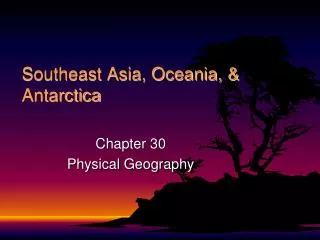
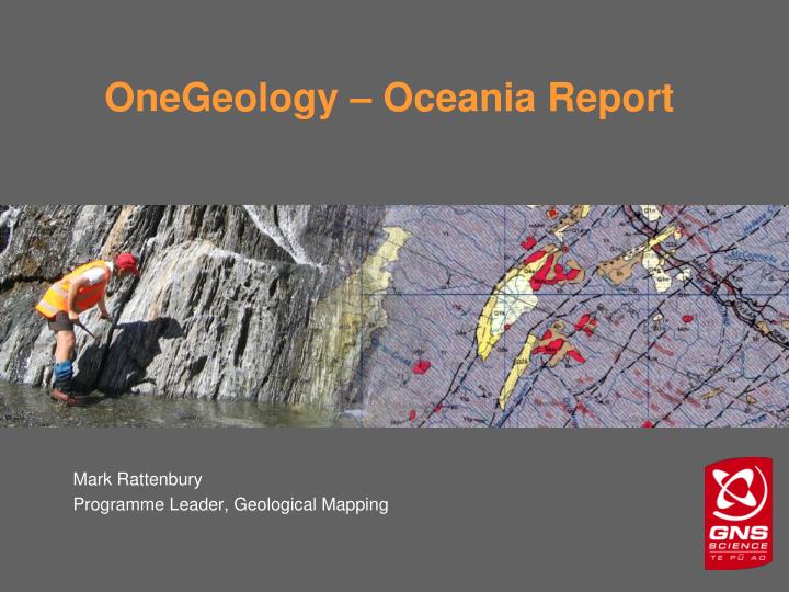
OneGeology – Oceania Report. Mark Rattenbury Programme Leader, Geological Mapping. Fiji. New Caledonia. Australia. Plate boundary zone. Pacific Plate. Australian Plate. Challenger Plateau. Tasman Sea. Chatham Islands. Campbell Plateau. South Pacific Ocean.

E N D
OneGeology – Oceania Report Mark Rattenbury Programme Leader, Geological Mapping
Fiji New Caledonia Australia Plate boundary zone Pacific Plate Australian Plate Challenger Plateau Tasman Sea Chatham Islands Campbell Plateau South Pacific Ocean Plate boundary zone “Zealandia” the New Zealand continent NZ land Area 0.25 Million km2 Continental area >7.5 Million km2 Australian land area ~7.5 Million km2
New Zealand mapping: scales overs the decades…. Restricted coverage National coverage Before 1960 1:63,360 geological maps (various) 1:250,000 “4 Mile” Geological Map of NZ 1960-1969 1:1M Geological of New Zealand 1970-1979 1:63,360 geological maps (various) 1980-1989 1:50,000 + 1:25,000 geological maps (various) 1990-1999 1:1M GMNZ as GIS dataset QMAP 1:250,000 Geological Map of NZ 2nd edition including Vector GIS dataset 2000-2009 1:2M Geology of New Zealand 1:1M GMNZ 2nd ed. (OneGeology) After 2009 Various scales but with more emphasis on 3D subsurface geological maps
New Zealand was the first country outside of the technical working group to post a geological WMS! 1:1,000,000 Geological Map of New Zealand (GIS version of the 1972 1st edition To be replaced in 2010 by the 2nd edition – a derivative of the QMAP programme Served using PostGIS open source software accessing ArcSDE GIS data
Australia Australia is a participating country and Geoscience Australia is currently serving level 2 WFS for all of Australia at 1:2.5M, and eastern Australia, Northern Territory and Western Australia at 1:1M. Geoscience Victoria delivers level 2 WFS of their state at 1:250k. New Zealand New Zealand is a participating country and through GNS Science is serving a 1:1M geological map WMS to the OneGeology portal. The map is a chronostratigraphic-based bedrock and superficial geology digitally captured from the 1972 first edition of 1:1M Geological Map of New Zealand. These GIS data are stored in Oracle-ArcSDE and served to the portal using PostGIS software. A new edition of the 1:1M Geological Map of New Zealand is scheduled for completion in 2010 and will be served as a GeoSciML-compliant WFS. Melanesia[1] (Fiji, New Caledonia, Papua New Guinea, Solomon Islands, Vanuatu) Vanuatu is a participating country. Papua New Guinea is not a participating country but has bedrock and superficial geology map coverage in OneGeology through the Digital Geological Map of East and Southeast Asia at 1:2M served by Japan. Micronesia (including Federated States of Micronesia, Guam, Kiribati, Marshall Islands, Nauru, Northern Mariana Islands, Palau, Wake Island) No participation in OneGeology or geological map coverage on portal. Polynesia (including American Samoa, Cook Islands, Easter Island, French Polynesia, Loyalty Islands, Niue, Pitcairn Islands, Samoa, Tokelau, Tonga, Tuvalu, Wallis and Futuna islands) No participation in OneGeology or geological map coverage on portal. [1]Eastern Indonesia is sometimes included in Melanesia but Indonesia as a whole is grouped by OneGeology under East Asia)
Postscript Discussed availability of geological maps of French protectorates in the South Pacific with Philippe Rossi. He is able to assist with finding and organising hosting of maps for French Polynesia and New Caledonia. GNS Science will undertake to contact Pacific Island government representatives with geological responsibilities to encourage posting of geological maps, with assistance if required.