Download
1 / 1
10 likes | 144 Views
The Structural and Geodynamic Evolution of the Black Sea Basin Stuart Egan & David Meredith. 1. Regional tectonic setting:. 5. Application of modelling of the eastern Black Sea basin:. 3. The eastern Black Sea basin:.

E N D
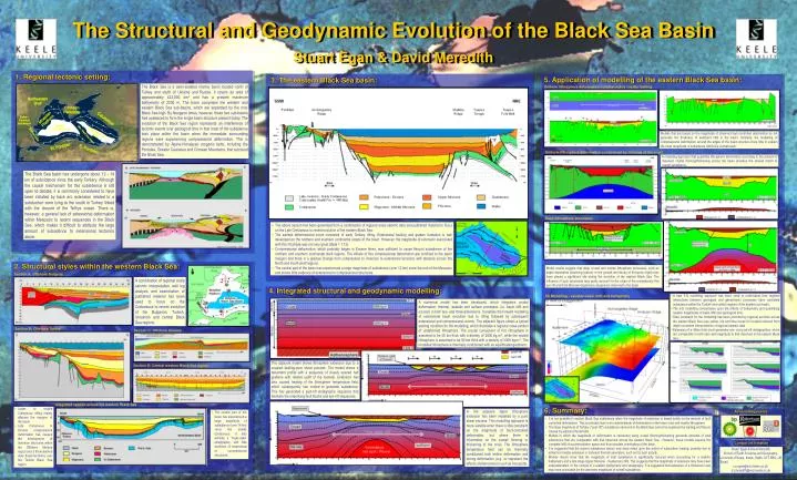
The Structural and Geodynamic Evolution of the Black Sea Basin Stuart Egan & David Meredith 1. Regional tectonic setting: 5. Application of modelling of the eastern Black Sea basin: 3. The eastern Black Sea basin: The Black Sea is a semi-isolated marine basin located north of Turkey and south of Ukraine and Russia. It covers an area of approximately 423,000 km2 and has a present maximum bathymetry of 2200 m. The basin comprises the western and eastern Black Sea sub-basins, which are separated by the mid-Black Sea high. By Neogene times, however, these two sub-basins had coalesced to form the single basin structure present today. The evolution of the Black Sea region represents an interference of tectonic events over geological time in that most of the subsidence took place within the basin when the immediate surrounding regions were experiencing compressional deformation. This is demonstrated by Alpine-Himalayan orogenic belts, including the Pontides, Greater Caucasus and Crimean Mountains, that surround the Black Sea. Uniform lithosphere deformation constrained by crustal faulting Models that are based on the magnitude of observed fault controlled deformation do not generate the thickness of sediment infill in the basin. Similarly, the modelling of compressional deformation around the edges of the basin structure does little to explain the large magnitude of subsidence within the central basin. Uniform lithosphere deformation constrained by thinning of the crust A modelling approach that quantifies lithosphere deformation according to the amount of observed crustal thinning/thickening across the basin provides the closest match to overall subsidence. The Black Sea basin has undergone about 12 - 14 km of subsidence since the early Tertiary. Although the causal mechanism for this subsidence is still open to debate, it is commonly considered to have been initiated by back arc extension related to a subduction zone lying to the south in Turkey linked with the closure of the Tethys ocean. There is, however, a general lack of extensional deformation within Mesozoic to recent sequences in the Black Sea, which makes it difficult to attribute the large amount of subsidence to extensional tectonics alone. Deep lithosphere processes • The above section has been generated from a combination of regional scale seismic data and published material to focus on the Late Cretaceous to recent evolution of the eastern Black Sea: • The earliest deformational event consisted of early Tertiary rifting. Extensional faulting and graben formation is well developed on the northern and southern continental slopes of the basin. However, the magnitude of extension associated with this rift phase was not very great (Beta = 1.13). • Compressional deformation, which probably began in Eocene times, was sufficient to cause flexural subsidence of the northern and southern continental shelf regions. The effects of this compressional deformation are confined to the basin margins and there is a gradual change from compression to inversion to extensional tectonics with distance across the North and South shelf regions. • The central part of the basin has experienced a large magnitude of subsidence (over 12 km) since the end of the Mesozoic and shows little evidence of extensional or compressional structures. 2. Structural styles within the western Black Sea: Model results suggest that deep crustal and mantle lithosphere processes, such as depth dependent stretching (above) or the growth and decay of hot-spots (right) may have played a significant role during the evolution of the eastern Black Sea. The influence of such processes may partly account for the origin of the anomalously thin syn-rift and thick Miocene-Quaternary sequences observed in the basin. Section A: Offshore Bulgaria A combination of regional scale seismic interpretation, well log analysis and examination of published material has been used to focus on the Cretaceous to recent evolution of the Bulgarian, Turkish, Ukrainian and central Black Sea regions. 4. Integrated structural and geodynamic modelling: • A new 3-D modelling approach has been used to understand how regional interactions between geological and geodynamic processes have controlled subsidence within the Turkish and central regions of the eastern sub-basin. • The 3-D modelling concentrates upon the effects of bathymetry and quantifying realistic magnitudes of basin infill over geological time. • Data constraint for the modelling has been provided by regional sections across the eastern Black Sea (see yellow, red and blue boxes for location) derived from depth-converted interpretations of regional seismic data. • Extension of a 45km thick crust generates syn- and post-rift stratigraphies, which are comparable in both ratio and magnitude to that observed in the eastern Black Sea. 3D Modelling - variable basin infill and bathymetry A numerical model has been developed, which integrates crustal deformation, thermal, isostatic and surface processes (i.e. basin infill and erosion) in both two- and three-dimensions. It enables the forward modelling of extensional basin evolution due to rifting followed by subsequent extensional and compressional events. The adjacent figure shows a typical starting condition for the modelling, which illustrates a regional cross-section of undeformed lithosphere. The crustal component of this lithosphere is assumed to be 35 km thick with a density of 2800 kg.m-3, while the mantle lithosphere is assumed to be 90 km thick with a density of 3300 kg.m-3. The modelled lithosphere is thermally conditioned with an equilibrated geotherm. Section B: Offshore Turkey Section C: Offshore Ukraine The adjacent model shows lithosphere extension due to a coupled faulting-pure shear process. The model shows a basement profile with a sequence of closely spaced half grabens with relative uplift of the footwall. Extension has also caused heating of the lithosphere temperature field, which subsequently has cooled to generate subsidence. This has generated a post-rift stratigraphic sequence that blankets the underlying fault blocks and syn-rift sequences. Section D: Central western Black Sea region Integrated section across the western Black Sea 6. Summary: • Lower to middle Cretaceous rifting mainly affected the margins of the basin. • Late Cretaceous to Eocene compressional deformation has caused the development of inversion structures within the Offshore Ukraine region and a thick-skinned style thrust tectonics over the Turkish Black Sea region. In the adjacent figure lithosphere extension has been modelled by a pure shear process. This modelling approach is more suitable when there is little constraint on the magnitude of fault-controlled deformation, but where there is information on the overall thinning or thickening of the crust. The lithosphere temperature field can be thermally conditioned both before deformation and during deformation (e.g. to represent the effects of phenomenon such as hot-spots). Acknowledgements • The central part of the basin has experienced a large magnitude of subsidence (over 14 km) since the middle Cretaceous. It also exhibits a "layer-cake" stratigraphy, with little evidence of extensional or compressional structures. • It is not possible to explain Black Sea subsidence when the magnitude of extension is based solely on the amount of fault controlled deformation. This is probably due to an underestimate of deformation in the lower crust and mantle lithosphere. • The large magnitude of Tertiary ("post-rift") subsidence observed in the Black Sea cannot be explained by loading and flexure caused by adjacent thrust belts. • Models in which the magnitude of deformation is calculated using crustal thinning/thickening generate amounts of total subsidence that are comparable with that observed across the eastern Black Sea. However, these models assume the complete infill of accommodation space and thus simulate overloading of the basin. • It is suggested that the basin's subsidence history may have relied upon the action of subsurface loading, possibly due to enhanced mantle extension or transient thermal anomalies, such as hot spot activity. • Models results show that the magnitude of total subsidence is significantly reduced when accounting for a realistic bathymetry and a late stage Upper Miocene - Quaternary infill. This suggests that the magnitude of extension may have been underestimated. In the context of a realistic bathymetry and stratigraphy. It is suggested that extension of a thickened crust may have accounted for the observed magnitude of overall subsidence. Contact information Stuart Egan & David Meredith School of Earth Sciences and Geography, University of Keele, Keele, Staffs, ST5 5BG, UK Email: s.s.egan@esci.keele.ac.uk; d.j.meredith@esci.keele.ac.uk