Download
1 / 44
440 likes | 449 Views
ISLAND-SCALE CIRCULATIONS OF THE ISLAND OF HAWAII DURING HARP AND THE SUMMER OF 2004 Presented by Yi-Leng Chen Department of Meteorology University of Hawaii at Manoa 2525 Correa Road Honolulu, HI 96822 Email: yileng@hawaii.edu November 2 9 , 2006, National Central University.

E N D
ISLAND-SCALE CIRCULATIONS OF THE ISLAND OF HAWAII DURING HARP AND THE SUMMER OF 2004 Presented by Yi-Leng Chen Department of Meteorology University of Hawaii at Manoa 2525 Correa Road Honolulu, HI 96822 Email: yileng@hawaii.edu November 29, 2006, National Central University
Introduction • Results from HaRP data analyses on the leeside • MM5/LSM validation • Effect of trade-wind strength • Effects of terrain heights and sizes • Future work
INTRODUCTION Previous research is mainly on the windward side. Leeside studies are few. Schroeder (1981) studied the airflow over northwestern Hawaii and suggested: • The sea-breeze variability there is affected by large-scale cloud cover and trade winds, and the thermal properties of the lava surface. • Land-sea thermal contrast supports sea-breeze advance whereas thermally induced mixing enhances trade winds that retard the sea breeze.
Patzert (1969) first reported the airflow over ocean from 15-yr ship observations with the existence of the lee vortices. • The first aircraft probing of Hawaiian wakes was done by Nickerson and Dias (1981). • Shedding lee vortices • During HaRP, the wake circulations were investigated by Smith and Grubisic (1993) from early morning aircraft flight-level data. • Quasi-steadyleeside vortices.
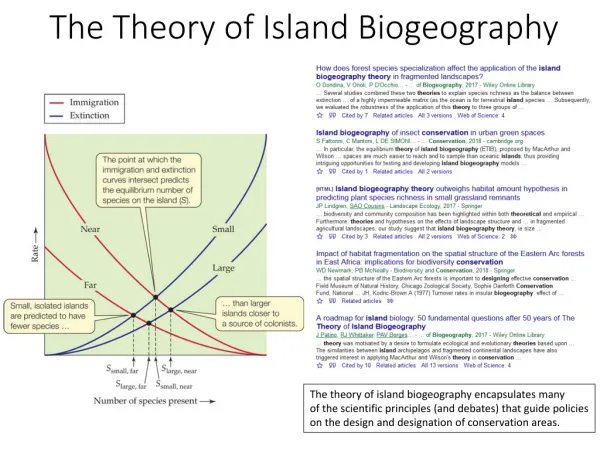
Studies of rainfall (Leopold 1949; Taliaferro 1959; Schroeder 1977; Meisner 1979; lyons 1982; Giambelluca et al. 1986; Chen and Nash 1994; Chen and Feng 1995; and others): • Rainfall maxima on the windward side due to the convergence, and orographic lifting aloft (Chen and Nash 1994; Chen and Feng 1995). • Rainfall minima on the leeside and dry areas atop high mountains. More rainfall in Kona with a maximum in the summer. • Giambelluca et al. (1986) showed that for Hawaiian islands, rainfall maxima on mountain tops lower than trade-wind inversion.
From 9-year rainfall data, Schroeder et al. (1977) showed the diurnal rainfall frequency maximum in the afternoon at Kealakekua (~ 480 m elevation) and Holualoa Makai (~ 490 m elevation) on the central lee-side Kona lower slopes. At the Kona airport along the coast maximum rainfall frequencies persist through the late evening. They suggested that a convergence zone at night between the downslope mountain breezes and the lee vortices might be the reason for the prolonged evening rainfall maximum.
Other possible explanations about rainfall production in Kona : • Convective clouds formed over the land or near the shore drifted inland with the sea breeze (Leopold 1949)? • The convergence between the trade-wind and the sea breeze (Giambelluca et al. 1986)? • The convergence between the two lee vortices as a result of island blocking (Patzert 1969)?
Numerical studies on the island-scale circulations by Smolarkiewicz et al. (1988), Rasmussen et al. (1989, 1993),and Ueyoshi and Han (1991). • Land surface processes were crudely treated in their • models. • The diurnal cycle of the leeside circulations were not • studied in details. • Chen and Feng (2001) used MM5 to study the effects of terrain and trade-wind inversion on airflow and weather without the diurnal heating cycle. • Feng and Chen (2001) used MM5 and a simple land surface model to simulate the nighttime flow regime with the entire island covered by tropical rain forest. • Zhang et al. (2005b) with MSM/LSM demonstrate the important effects of surface properties on the sea-breeze behavior over the northwest Hawaii.
Theoretical studies of ideal airflow past idealized obstacle • For numerical studies of a stratified airflow past idealized mountains without diabatic heating, and surface friction, Fr and horizontal aspect ratio (β) are control parameters (Smolarkiewicz and Rotunno 1989, 1990; Crook et al. 1990; Schar et al. 1997; Smith 1989; Olafsson et al. 1996; Bauer et al. 2000). • The effect of bottom friction is considered by Grubišić et al. (1995) without diabatic heating. The flow past larger obstacle will be more “viscous”. • For a stratified, nonrotating, inviscid flow past obstacles with thermal forcing, the flow is controlled by Fr and a characteristic scale of thermal forcing (η) (Reisner and Smolarkiewicz 1994). The surface thermal forcing is important for flow regime transition, but crudely treated.
Scientific issues: The effects of land surface forcing (diurnal heating cycle and surface friction), island blocking on the lee-side circulations and rainfall distributions have not been well understood. • What are the mechanisms for the rainfall production in the Kona area? • How do the trade-wind strength and direction affect the leeside circulations and weather?
Scientific issues: Island blocking (Fr=U/Nh) Island-scale circulations and weather Mountain heights (h) ? Surface thermal forcing Orographic lifting ? Island-scale circulations and weather Island sizes ? Surface forcing Effects of mountain heights and sizes on the island-scale circulations and weather through the physical processes (marked by ‘?’)have not been well addressed before.
Objectives: • To study the effects of the diurnal heating cycle and island blocking on the lee-side circulations and rainfall distributions during the HaRP (July-August 1990) period. • To assess the performance of the MM5/LSM in the simulation of the diurnal island-scale circulations with improved land surface conditions. • To study the effects of the upstream trade-wind strength on the leeside circulations and weather using MM5/LSM. • To study how the terrain heights and island sizes affect the diurnal variations of island-scale circulations and weather using MM5/LSM.
Results of data analyses of the leeside circulations and rainfall (Yang and Chen 2003, MWR). • The most significant adiabatic descent of trade-wind flow aloft occurs on the northwestern and southwestern lee sides of the island, especially for a strong trade-wind flow. • On the Kona lower slope, the rainfall maximum occurs in the late afternoon with a relatively low LCL, most likely due to the orographic lifting of upslope flow. • The wake return flow has a higher moisture content than the rest of the wake. • The rainfall along the central Kona coastal area is more for stronger trade wind days, possibly due to the enhanced moist convergence between the land breezes in the evening and a stronger and moist return flow offshore.
2. Validation of MM5/LSM with HaRP data • Four domains with two-way nesting used ( 81 km, 27 km, 9 km and 3 km). • Warm rain, cloud-radiation scheme (Dudhia 1989), Hong and Pan PBL (1996), and Grell cumulus parameterization. • The land use, vegetation fraction and soil type for LSM were recompiled (Zhang et al. 2005) to improve the land surface data used by MM5 (e.g. mixed forest for the entire island). • The model is initialized by the NCEP/NCAR reanalysis (2.5° х 2.5°). The initial soil moistures and soil temperatures were generated by running MM5/LSM for two months prior to the HaRP period.
The mean surface wind vectors at 50 PAM stations during HaRP (July 11 to Aug. 24, 1990) 1400HST 1400HST Observation Simulation 0200HST 0200HST Simulation Observation
Aircraft data NCEP/NCAR reanalysis The mean wind profiles upstream of Hilo for 22 days during HaRP
(a) Composite surface winds from 15-yr ship observations. Observation Simulation b a (b) Mean simulated surface winds during HaRP. (Patzert 1969)
Model sensitivity tests. Slab refers to the five-layer simple soil model. “NEW” refers to tests using new land use, soil type and vegetation fraction data (Zhang et al. 2005a). Spin-up “YES” refers to tests using improved initial soil moisture and soil temperature from the 24th hour simulation of the previous day.
c 35 a b CTL 30 25 20 15 10 5 0 0 5 10 15 20 HST 35 35 c TEST3 d TEST1 30 30 25 25 d 20 20 15 15 10 10 5 5 0 0 0 5 10 15 20 HST 0 5 10 15 20 HST (a) Soil temperatures at the summit of Mauna Kea on June 20 1980 (Schroeder 1993). (b) Simulated soil temperatures initialized by NCEP/NCAR reanalysis at the soil layers close to the observation depths for CTL. (c) For TEST3. (d) For TEST1.
The island-wide divergence computed from winds at 21 PAM stations along the coast of the island of Hawaii during the diurnal cycle on August 10, 1990
Summary of model validation • The island blocking, orographic lifting, wake circulation, and the diurnal cycles of the surface winds over the Island of Hawaii are well simulated. • With better surface conditions in the model coupled with OSU-LSM, the simulated thermal forcing over land is improved. • Some simulation errors exist for surface winds and temperatures. Besides the model physics bias, the errors could also be related to: • the weaker than observed upstream trade-wind flow. • the uncertainty of the thermal properties of the underlying surface, especially the lava rocks/soils (Zhang et al. 2005)
3. Effect of trade-wind strength on the leeside circulation in the summer of 2004 • Low-level wind data from GFS (1°× 1°) at 4 gridpoints about 200 km upstream of Hilo were used to compute the wind speed and directions each day from July 15 to August 31. • A strong trade-wind day: a mean wind speed > 7 m s־¹, 60°< wind direction< 90°. Eight strong trade-wind days (16, 17 and 29 July, 7, 16, 24, 25 and 28 August) are chosen. The mean wind speed: 7.9 m s־¹ and mean wind direction: 79°. • 8 weak trade-wind days (18, 19, 22 and 30 July, 15, 20, 29 and 30 of August) chosen from the weakest mean wind speed with 60°< wind directions <90°. The mean wind speed and direction: 5.1 m s־¹ and 81°.
8 strong trade days 8 weak trade days The composite sea-level pressure (hPa) with an interval of 2.5 hPa and geopotential heights and temperature at 500-hPa level at 0000 UTfrom GFS data. The 4 dark points are used for the upstream wind analysis.
8 strong trade days 8 weak trade days The composite surface winds for the 8 strong, the 8 weak trade-wind days, and their difference in the summer of 2004. Strong - weak
The mean surface winds for strong and weak cases Strong 1400HST Strong 0200 HST Weak 1400HST Weak 0200HST
Strong Weak Strong Weak Mean vertical velocities along the transect in the northern area of the island with an interval of 0.2 m s־¹, and along the southern Kona transect with an interval of 0.05 m s־¹.
Potential temperature Potential temperature Strong Weak Strong Weak Mixing ratio Mixing ratio The mean potential temperature with an interval of 0.5 K and the mean mixing ratio with an interval of 0.5 g kg־¹ on 500 m above the sea level in the summer of 2004.
Strong Weak The rainfall accumulation with an interval 20 mm. The thick solid line square is used for rainfall statistic analyses. Strong Weak The composite vertical velocity at 2200 HST with an interval 0.05 m s־¹
a a b b b The diurnal rainfall frequency using 9-yr obs data from Schroeder et al. (1977) Simulated 1-h rainfall (mm) and rainfall frequency at (a) Kealakekua, and (b) Holualoa Makai along the Kona coast from July 15 to August 31, 2004.
Simulations with NCEP/NCAR reanalysis (2.5°×2.5°) Strong Weak Simulated mean surface winds and total rainfall (mm) for the 8 strong trade-wind days and 8 weak trade-wind days.
Summary of effect of trade-wind strength Two rainfall regimes on the central Kona coastal region. The afternoon/late afternoon regime with the diurnal rainfall frequency maxima. The evening rainfall regime with the diurnal rainfall amount maximum.
4. Effects of terrain/island heights and sizes CTRL: with the real terrain heights TER70: with 70% of the terrain heights of CTRL TER35: with 35% of the terrain heights of CTRL S_TER: with a shrunk terrain of 1/7 the size of TER35 terrain, about the size of Kauai. The shrunk terrain of the island of Hawaii from TER35 with a shading interval of 200 m.
CTRL TER70 The mean surface winds during HaRP. Thin solid lines are terrain height contours with 1000 m interval. Thick solid lines are transects for vertical cross sections. d TER35
CTRL TER70 TER35 1400HST 1400HST 1400HST 1400HST 1400HST 1400HST The surface temperature deviations from the mean upstream aircraft sounding during HaRP at the same level with a contour interval of 1 K. 1400HST 1400HST 1400HST Vertical integrated cloud water content (g kg־¹ 10־³) with a contour interval of 40 at 1400 HST.
0500HST 0500HST TER70 CTRL 0500HST TER35 The surface temperature deviations from the mean upstream aircraft sounding during HaRP at the same level with a contour interval of 1 K.
1400HST 1400HST 1400HST 1400HST 0200HST 0200HST 0200HST 0200HST CTRL TER70 TER35 Mean zonal wind speed (m s־¹) with a contour interval of 0.5 m s־¹ during HaRP for the Kona transect.
1400HST 1400HST 1400HST 0200HST 0200HST 0200HST CTRL TER70 TER35 Mean zonal wind speed (m s־¹) with a contour interval of 1 m s־¹ during HaRP for the Hilo transect
Control run Fr=~0.17 b b CTRL Fr=~.2 TER70 Fr=~0.25 The total rainfall (mm) with a contour interval of 100 mm during HaRP. Fr=U/Nh. U~ 7m s־¹, N=0.01 s־¹, h~4000m, 2800m, 1400m for CTRL, TER70, and TER35, respectively. TER35 Fr=~0.5 The rainband/rainfall on the windward side increases for a higher Fr with a larger U (Carbone et al. 1998). However, this study shows that rainfall on the windward side decreases for a higher Fr for a lower terrain height.
The total rainfall accumulation (mm) during HaRP for S_TER and TER35 with a contour interval of 100 mm (thick solid lines). The island size for S_TER is 1/7 of TER35. Both have the same mountain heights. Effect of terrain/island sizes TER35 S_TER Giambelluca et al. (1986) showed for Hawaiian islands, rainfall maxima on mountaintops with heights lower than trade-wind inversion. These mountains are smaller in size as compared with the Big Island.
Summary of effects of terrain heights and sizes: • The terrain heights affects not only island blocking, but also the land surface thermal forcing during the diurnal cycle, which can feedback to the island-scale circulations and weather. • The orographic lifting of upslope flow is the main mechanism for the cloud/rainfall production on the Kona slope in the afternoon. • Both terrain sizes and heights affect the distribution of rainfall maximum. • Fr is not a control parameter for the production of the windward trade-wind rainfall.For stronger trades (larger Fr), rainfall is higher; nevertheless, for a lower terrain height (also larger Fr), rainfall is less.
Future work • To conduct controlled simulations for a given upstream trade-wind speed and direction from one sounding data. • To analyze satellite and radar data with respect to the diurnal cycle of the island-scale weather in the summer and other seasons, and their interannual variability. • To study the island-scale climate and airflow, their interannual variability, through downscaling of the regional climate to island scale with mesoscale models. • To improve the model initial conditions by data assimilation with satellite and radar data. • Shifting to WRF model.