Download
1 / 18
180 likes | 302 Views
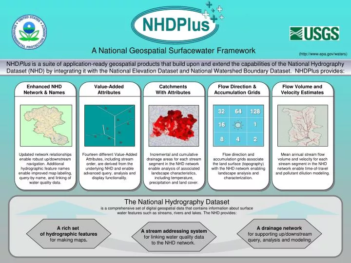
64. 32. 128. 1. 16. 8. 4. 2. A National Geospatial Surfacewater Framework. (http://www.epa.gov/waters).

E N D
64 32 128 1 16 8 4 2 A National Geospatial Surfacewater Framework (http://www.epa.gov/waters) NHDPlus is a suite of application-ready geospatial products that build upon and extend the capabilities of the National Hydrography Dataset (NHD) by integrating it with the National Elevation Dataset and National Watershed Boundary Dataset. NHDPlus provides: Enhanced NHD Network & Names Value-Added Attributes Catchments With Attributes Flow Direction & Accumulation Grids Flow Volume and Velocity Estimates Updated network relationships enable robust up/downstream navigation. Additional hydrographic feature names enable improved map labeling, query-by-name, and linking of water quality data. Fourteendifferent Value-Added Attributes, including stream order, are derived from the underlying NHD and enable advanced query, analysis and display functionality. Incremental and cumulative drainage areas for each stream segment in the NHD network enable analysis of associated landscape characteristics, including temperature, precipitation and land cover. Flow direction and accumulation grids associate the land surface (topography) with the NHD network enabling landscape analysis and characterization. Mean annual stream flow volume and velocity for each stream segment in the NHD network enable time-of-travel and pollutant dilution modeling. The National Hydrography Dataset is a comprehensive set of digital geospatial data that contains information about surface water features such as streams, rivers and lakes. The NHD provides: A rich set of hydrographic features for making maps. A drainage network for supporting up/downstream query, analysis and modeling. A stream addressing system for linking water quality data to the NHD network.
Enhancements to NHDPlus Medium Resolution (1:100,00-scale NHD) Complete build/refresh toolset (2010) National refresh using (2011): Latest NHD and NED Now completed WBD Monthly flow estimates Ability to incorporate water additions and removals Future spatial integration of NHD and WBD through stewardship program High Resolution (1:24,000-scale or better NHD) State pilots
NHDPlus Data – Tools and Technology EPA NHD Editing Tools ArcGis 9.3.1 DT Shapefiles and dbfs Geographic NAD 83 NHD v1.06 PGDB2Shp Shp2PGDB BuildFlow XMLExtract ComID Reachcode Allocator NHDPlus v2.0 Build/Refresh NHDPlus v1.0 Med Res Stewardship • NHD Med Res Snapshot v1.06 (1.07?) • WBD Snapshot v2.0 • ArcGis 9.3.1 DT • SQL Server • Shapefile, grids, dbfs and mdfs (fgdb?) • Geographic NAD 83 • Non-spatial flow table connections • ComID, M-values, reachcodes, fcodes, fdate, ReachSMDate • WBD Reachcode Sync • Non-NHD VAAs • In/out network flag • NHD Med Res Snapshot v1.04 • ArcGis 9.3.1 DT • Shapefiles, grids and dbfs • Geographic NAD 83 • ComID, M-Values, reachcode, ftype, VAAs, Flowdir
NHDPlus Applications –Tools and Technology NHDPlus Tools/Services NHDPlus Applications/Tools • Basin Delineator • Catchment Allocation and Accumulation • NHD Flow Table Navigator • NHD Releveler • NHDPlus Build/Refresh User tools: NHD QAQC and NHDPlus VAA Computation • VAA Navigator • CT River Atlas Basin Delineation Web Service • ArcGis 9.3.1 DT • SQL Server • Shapefile, grids, dbfs and mdfs • Some pgdb (fgdb?) • Non-spatial flow table connections • ComID, M-values, reachcodes, Ftypes, Fcodes, Fdate, ReachSMDate
WQSDB GRTS Water Quality Standards Nonpoint Source Grants National Hydrography Dataset Plus ATTAINS STORET Water Quality Assessments, Impaired Waters & Total Maximum Daily Loads Water Quality Monitoring WATERS/RAD Data Architecture (Watershed Assessment, Tracking & Environmental ResultS) (www.epa.gov/waters) Reach Address Database (RAD)
Data Accessible Through WATERS Public Access • Listed Impaired Waters • Assessed Waters • Beaches • Clean Watershed Needs • Combined Sewer Overflows • CWSRF Benefits Reporting • Permitted Dischargers • Fish Consumption Advisories • Fish Tissue Data • Impaired Waters with TMDLs • Sewage No Discharge Zones • Nonpoint Source Projects • Water Quality Standards • Water Quality Stations (coming in 2010!) Internal Access Only • Drinking Water Intakes • Source Water Areas • Special Appropriations Projects
WATERS Web Services Public facing Web services for creating and applying NHD events and NHDPlus, including mapping services Enhanced from DB and SOAP to HTTP/REST Code playground and javascript library Transparency and efficiency for developers Visit www.epa.gov/waters/tools Performance concerns with EPA IT infrastructure!
Viewing WATERS Data in Google Earth • Access to framework geospatial datasets stored in the WATERS Database and to general purpose interactive service panels. • Dialog boxes providing access to tools, services, and information, such as NHD feature name query, total waters, up/downstream navigation, watershed reports, ATTAINS reports, etc. • Access to indexed water program features, with hyperlinks to additional attributes, and context sensitive analysis services, such as up/downstream navigation and watershed reports. www.epa.gov/waters/tools
So What? • Second National Geographic special issue on Water in recent years (April, 2010) • 2010 National Water Quality Monitoring Conference (Denver, CO – April 26-29), Monitoring From the Mountains to the Sea, plenary speakers • Anne J. Castle, Assistant Secretary for Water and Science, U.S. Department of the Interior • G. Tracy Mehan III, Principal, The Cadmus Group and Former Assistant Administrator for Water, U.S. Environmental Protection Agency • Thomas L. Tidwell, Chief, U.S. Forest Service • Robert M. Hirsch, Research Hydrologist and Former Associate Director for Water, U.S. Geological Survey • We are in trouble in managing our water resources – non-point source pollution, climate change (lack of stationarity) creates moving target, oils spills …
National Wildlife Refuge System National Fish Hatchery System Impaired Waters Co-Occurrence of Impaired Waters and FWS Properties An EPA, FWS and USGS Joint National Assessment
Anticipated NHDPlus Applications • First ever spatially-based national pesticide risk assessment • Clean Water Act jurisdictional analysis update • ESRI Hydro Base Map • Native American historical migration paths (Share your NHDPlus applications with others at www.epa.gov/waters > NHDPlus Quicklink)
Maintaining and Enhancing Our Surfacewater Infrastructure • We succeeded at production – putting the plumbing in place (70 million investment?) • However, stewardship has stumbled largely due to institutional change (production to stewardship) combined with A-76 competitive sourcing fallout – tools and process too cumbersome, loss of institutional knowledge, project management issues, … • Need to have a sense of urgency about our work - slowly rebounding, but extra resources are one time allocation and another usgs reorganization is rumored • Being able to articulate a short/mid/long term NHD/WBD (NHDPlus/Streamstats) plan – including technical architecture - will bode well for this program • I don’t believe that the stewardship community can sustain another several years like the last 3
Questions? Tommy Dewald, USEPA Office of Waterdewald.tommy@epa.gov (www.epa.gov/waters > NHDPlus Quicklink)
NHDPlusTools and Applications RAD/Waters CWA Programs Georeferencing and Hydrologic Analysis Waterbody Assessments, Impairments, TMDLs National Aquatic Resource Surveys Pesticide Reauthorization Drinking Water Source Water Protection Areas EPA Applications USGS Applications National User Community • The Nature Conservancy • Army COE • FWS • Forest Service • NOAA • Bureau of Reclamation • Universities: PSU, TX, ID, KS, MS, KY, MD, CO • States: KS, NY, PA, NH, CA, NE, TX, more… • High Resolution NHD Stewards • ESRI • Sparrow Nutrient Modeling • NAQWA - Major River Basin Modeling • Great Lakes Restoration Initiative • StreamStats – current base for some states • StreamStats – future built using NHDPlus Build/Refresh tools
Geo Web Services Need to Perform • Performance issues for large data volumes • Boosting performance • Database tuning • Pre-computed network navigation attributes • Pre-computed results geometries • Cloud computing • Others? Spinning Pinwheel (formerly, the Dreaded Dancing Dot)


![Making maps, many maps! [What is GIS?]](https://cdn1.slideserve.com/3592384/making-maps-many-maps-what-is-gis-dt.jpg)