Download
1 / 16
160 likes | 455 Views
Prevailing Wind Patterns. Weather Dynamics Unit Science 10 Mrs. S. Pipke-Painchaud. Wind. “Movement of air in the atmosphere” (Nelson Science 10 516). Local or Regional Winds: Occur in a localized or small area Prevailing Winds: Winds that affect large areas (Nelson Science 10 516).

E N D
Prevailing Wind Patterns Weather Dynamics Unit Science 10 Mrs. S. Pipke-Painchaud
Wind • “Movement of air in the atmosphere” (Nelson Science 10 516). • Local or Regional Winds: • Occur in a localized or small area • Prevailing Winds: • Winds that affect large areas • (Nelson Science 10 516)
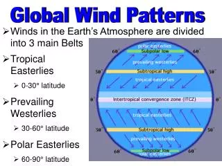
Coriolis Effect • Named after Gaspard deCoriolis • French Mathematician • Because of the Earth’s rotation anything moving long distances appear to change direction • “apparent change of direction in a moving object in a rotating system is called the Coriolis Effect” (Nelson Science 10 516). • (NS10 516) • “tendency for any moving body on or above the earth's surface, e.g., an ocean current or an artillery round, to drift sideways from its course because of the earth's rotation” (InfoPlease.com) http://www.theozonehole.com/coriolis.htm
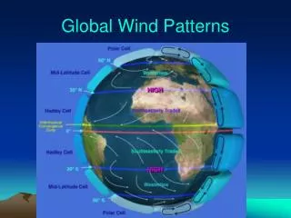
Earth rotates Eastward • Northern Hemisphere (counterclockwise) – move to right • Southern Hemisphere (Clockwise) – move to left • Noticed the least at the equator and most at the poles
http://www.worldstats.org/general_world/maps/prevailing_winds_big.shtmlhttp://www.worldstats.org/general_world/maps/prevailing_winds_big.shtml
http://research.haifa.ac.il/~maritime/departm/lessons/ocean/wwr199.gifhttp://research.haifa.ac.il/~maritime/departm/lessons/ocean/wwr199.gif
Convection Currents • Video: http://www.wfu.edu/physics/demolabs/demos/4/4b/4B2010.html • http://www.wfu.edu/physics/demolabs/demos/avimov/byalpha/cdvideos.html
Please refer to page 517 in your textbook • Figure 2 • Skim through the information on page 516 • Paragraph 2 “to understand why the …” • In 1492, Christopher Columbus relied on two important prevailing winds to sail to the Americas and home again. • A) What wind did he use to travel to America? • B) What wind did he use to travel home? • A) Northeast trade winds • B) Mid-Latitude westerlies
Animations • Exploring Earth • **http://www.classzone.com/books/earth_science/terc/content/visualizations/es1904/es1904page01.cfm?chapter_no=visualization • http://www.classzone.com/books/earth_science/terc/content/visualizations/es1905/es1905page01.cfm?chapter_no=visualization • Danish Wind Industry Association • http://www.windpower.org/en/tour/wres/coriolis.htm
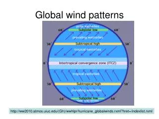
Causes of Prevailing Winds • Please read through pages 518-519 • First five paragraphs • Jet Stream: • “a current of fast moving air found in the upper atmosphere” (Univ. Illinois). • Can be 1000s of km long • Few 100 km wide • Few km thick • Generally, located 10-15 km up • The position of this upper-level jet stream denotes the location of the strongest SURFACE temperature contrast” (Univ. Illinois). • http://ww2010.atmos.uiuc.edu/(Gh)/guides/mtr/cyc/upa/jet.rxml
Jet Stream Maps • Jet Steam Images: • http://www.weatherimages.org/data/imag192.html • Environment Canada: • http://weatheroffice.ec.gc.ca/jet_stream/index_e.html • Weather.com • http://www.weather.com/maps/activity/aviation/saturdayusjetstream_large.html • California Weather Service • http://virga.sfsu.edu/scripts/namjetstream_modelsml.html
Effects of Prevailing Winds • Distribute solar energy from equator to poles (move air around the earth) • Convection currents enable a return of cold air south • Carry moisture • Help to cause a variety of precipitation types • “Remember that rising air tends to be warm and moist, while falling air tends to be cool and dry” (Nelson Science 10 519). • Nelson Science 10 519
Consider where convection currents meet • Equator: cloudy and rainy • 30* North Latitude: cool, dry falling air (desert like conditions) • Gobi (As), Sahara (Af), Mojave (NA), Great Basin (NA) and Sonoran (NA) • Deserts of North America (info on Hot and Cold Deserts of the world) • http://mbgnet.mobot.org/sets/desert/ofworld.htm • 60* North Latitude: 2 air systems meet • Unsettled conditions • Storms are stronger in the winter (because the Arctic receives no light = cold = greater temp difference from equator) • Nelson Science 10 519
Earth from Different Perspectives • **Exploring Earth (examine sea temperatures, earthquakes, etc.) • http://www.classzone.com/books/earth_science/terc/content/visualizations/es0101/es0101page01.cfm?chapter_no=visualization • Environment Canada • Wind Info: • http://lavoieverte.qc.ec.gc.ca/meteo/Documentation/Vent_e.html • International Polar Foundation: • Katabatic and Anabatic Winds • http://www.antarctica.org/UK/Envirn/pag/vents_cata_UK.htm
Sources: • Nelson Science 10 Textbook • Infoplease. Infoplease.com. Coriolis Effect • http://www.infoplease.com/ce6/weather/A0813558.html • University of Illinois • Jet Stream: http://ww2010.atmos.uiuc.edu/(Gh)/guides/mtr/cyc/upa/jet.rxml