Download
1 / 21
220 likes | 325 Views
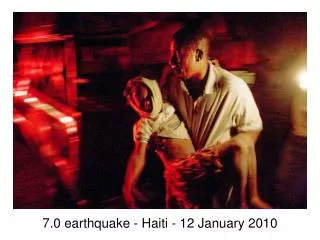
Near-Surface Geophysical Investigation of the 2010 Haiti Earthquake Epicentral Area. Eray Kocel, Robert R. Stewart, Paul Mann, and Li Chang AGL Research Update, University of Houston April 2014 . Outline. Introduction 2010, Haiti Earthquake with 200,000 death

E N D
Near-Surface Geophysical Investigation of the 2010 Haiti Earthquake Epicentral Area Eray Kocel, Robert R. Stewart, Paul Mann, and Li Chang AGL Research Update, University of Houston April 2014
Outline • Introduction • 2010, Haiti Earthquake with 200,000 death • No surface expression • Recent studies suggesting the existence of a blind fault • Selection of Survey Location • Léogâne fan= Epicentral area • No prior on-land seismic reflection data • Geophysical data • Density and Ultrasonic Lab. Measurements • Seismic Data • P-wave Refraction • Shear-wave via MASW • Shear-wave refraction • P-wave reflection • Gravity Data • Integrated Near-Surface Results • What we have learned so far
Haiti We are only 900 miles away from a major plate boundary Houston North American Plate Hispaniola Caribbean Plate
Haiti Project • January 12, 2010, 7.0 magnitude. • Known: Major strike slip fault, • Enriquillo Plantain Garden Fault Zone. • Hypothesis: Unrecognized, neighboring fault (Léogâne) 2010 Earthquake epicenter Objective Characterize and analyze the subsurface structure Measure near-surface sediment properties (3) Attempt to find and understand the blind faults that may have given rise to the 2010 earthquake (4) Better understanding the local geology
Survey Locations Why Léogâne? • Recent studies concentrated at this area • Interferogram and Aftershock studies • Uplift studies • Aerial and Satellite images • Seismicity studies • Enriquillo fault is dipping towards south • Léogâne fault is dipping towards North Calais et al, 2010 Hayes et al, 2010
Laboratory Measurements Sample B • No outcrop in the area, only fan sediments • Sample A and C collected 20km away • Sample B is collected 5km away • Survey location; Just south of EPGFZ Gardner’s relationship ρ estimated = 2.13g/cc ρ measured= 2.01 g/cc ρ= Vp0.25 = 0.31, Vp= 2250 m
Léogâne Surveys • Sources: • 2012- Hammer Source 4.5 kg • 2013-Accelerated Weight Drop 45 kg • 2014- Vibroseis
P-wave Refraction Studies Analysis completed on 2 seismic lines (Line A and Line B) for a 80 m deep model Line A (1)Top layers are thicker towards south (2)Low P-wave velocities for top 40 to 50 m (3)Relatively consolidated layer boundary is located between 40 to 50m Line B
Shear wave studies Shear wave velocities obtained by MASW method Line A • Low S-wave velocities for 20 m deep model • Line A- top layer shows slight thickening towards south • Overlapping lines (B and D) • Velocity inversion on line B and D observed Line D Line B
P-wave Reflection Studies Time migrated images revealed up to 500 ms (roughly 350 m) Line A • Overall low velocities observed • Top-low velocity layer thickens towards South • Abruptions and discontinuities observed • Strong reflection around 60-80 ms Line B
Gravity Analysis • Top sediment density obtained from lab. measurements and Gardner’s estimation, 2.0 g/cc • The bedrock the density is 2.7 g / cc • No prior well or seismic data • Thinning of layers towards North. • Localized gravity anomalies interpreted as the affects of faulting
Integrated Near-Surface Results • Known: (1)EPGF dipping south, (2)survey location • Gravity surveys: Thinning of fan sediments towards North • Refraction seismic: (1)Thickening low velocity layers towards South, (2)Boundary at 50m distance depth Subsurface Layers • Reflection seismic: (1)Channel bodies, (2)Some minor faults Relatively consolidated limestone unit <2250 m/s • Lab. Measurements with Seismic: Limestone vs unconsolidated sed. Boundary around 50 m >2250 m/s
Future Plans • Completed • 2012 and 2013 surveys were completed • Near-surface analysis provided useful geotechnical information • First on-land reflection seismic data • Tested node systems • Future plans • 2014 surveys with stronger seismic source • Imaging target up to 1-2 km • Full deployment of nodes (donations from Geospace)
Acknowledgements • Geoscientists Without Borders • Allied Geophysical Laboratories • Anoop William • Haiti Bureau of Mines and Energy employees • Gedco-processing software
50 50 0 0 Depth (m) Depth (m) 350 350
Houston North American Plate Hispaniola Caribbean Plate
Future Work distance depth Subsurface Layers
Distance (m) 850 245 m/s 260 m/s 500 Time (ms) 140 m/s 250 110 m/s 200 250 100 0