Download
1 / 40
670 likes | 1.12k Views
RIPARIAN ECOSYSTEM IMPORTANCE, THREATS, PROTECTION, ENHANCEMENT, RESTORATION, AND MANAGEMENT (also a little detention, retention, infiltration, Rain Gardens, wetlands, watersheds, etc).

E N D
RIPARIAN ECOSYSTEM IMPORTANCE, THREATS, PROTECTION, ENHANCEMENT, RESTORATION, AND MANAGEMENT (also a little detention, retention, infiltration, Rain Gardens, wetlands, watersheds, etc) • By Dave Derrick, with liberal help from Drs. Rich Fischer & Chester Martin, ERDC-EL, Ron Redman with AR Natural Resources Commission, & other sources, steal what ya can, always give credit!
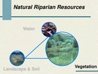
PHOTO BY FISCHER What are Riparian Areas?
Is There a Universally Accepted Definition of Riparian? Riparian (ri per' e n) adj. [ < L. riparius < ripa, a bank < IE. reipa, a steep edge] 1. of, adjacent to, or living on, the bank of a river or, sometimes, of a lake or pond, etc. Root for such words as: River Rip-rap Bank swallow (Riparia riparia) Brush rabbit (Sylvilagus bachmani riparius)
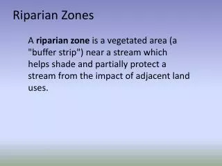
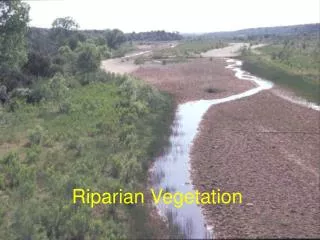
Riparian floodplains Riparian zones Riparian areas Riparian wetlands River margins Riverine bands Riverine floodplains Riverfront hardwoods Buffer strips Streamside vegetation Riparian Prairie Floodplain forests Riparian gallery forests Riparian swamps Riparian woodlands Riparian ecosystems Riparian forest stands Hardwood stringers Swamp forest Bottomland hardwoods Cottonwood bottomlands Streamside zones Riparian Corridors Riparian Buffer Strips Terminology describing vegetation adjacent to streams and rivers
GREAT RIPARIAN HERE, BUT RARE IN MANY AREAS, KASKASKIA RIVER, IL
“Crazy” river has kept folks back a little PHOTO FROM FISCHER
EPA research shows that when a watershed exceeds 10% impervious cover then some species will start to disappear from the streams & rivers. Exactly what is 10% impervious cover?
This is way more than 10% IN THE AIR-CHICAGO TO BUFFALO PIX BY DERRICK 6/15/2009
10% impervious cover can be large single family dwellings on 1 acre lots !!!
This is getting close to 10% impervious cover IN THE AIR-CHICAGO TO BUFFALO PIX BY DERRICK 6/15/2009
Riparian Vegetationintercepts sediment, pesticides, herbicides, and other materials in surface runoff Good for pollinators & insect production FROM FISCHER
Trimming or removal of vegetation can cause: Increased water temperature through loss of shading Increased surface runoff Sedimentation Reduced infiltration Altered stream flow Unstable streambanks Pix by Derrick, Atlanta, GA area
Provides litter and small & large woody debris important to aquatic organisms, insect production, shade, microhabitats, cover, etc. Riparian VegetationEffects on Streams FROM FISCHER
Buffer Requirements FUNCTION RIPARIAN BUFFER WIDTH • Water quality 5 to 30 m • Wildlife 30 to 500 m • Insect production 10 to 30 m • Flood attenuation 20 to 150 m • Detrital input 3 to 10 m • Stream stabilization 10 to 20 m From Dr. Craig Johnson, Utah State University These are not absolutes, widths can possibly change with additional knowledge from continued research. Note: It is possible that several functions can be accomplished within the same space.
FROM FISCHER Food Water Cover Riparian areas offer in proximity all three critical resources for wildlife
Over 70% of all terrestrial wildlife species use riparian corridors
trees Complexity Layers Species in layers Competition Detrital components Types shrubs Vertical Horizontal Riparian zones provide essential horizontal and vertical habitat complexity Herbaceoussubshrubs
A study on the Apalachicola River in FL. showed that 64 species of fish used the riparian area when the river was on the flood!!
Comparison of a single cage of juvenile salmon reared in intertidal river habitat below floodplain (left) and a single cage of fish reared in ephemeral floodplain habitats (right) after 54 days in respective habitats (Jeffres et al. 2008). From Dr. Rich Fischer
Native minnows dominated, but during one flood event, sunfish, perch, & bass were found!! Research showed that 24 species of fish (10,843 individuals) inhabited the 12 ag ditches studied!!
Winery in foreground is enrolled in the “Fish Friendly Farming” program, Russian River Watershed, CA This vinyard uses no chemicals & 100% solar powered
Region Northern floodplain forests Arizona New Mexico California Sacramento Valley, CA Mississippi Delta Southern Bottomland Hardwoods Percent Loss 70% 90-95% 90% 95-96% 98% 82-85% 80-90% Regional Trends of Riparian Losses From Fischer
Easement Programs Emergency Watershed Protection Program (Floodplain Easements) Farm and Ranch Lands Protection Program Grassland Reserve Program Healthy Forests Reserve Program Wetlands Reserve Program USDA-NRCS Programs & Information for Soil Conservation Slide 25 Courtesy John Whitney, DC, NRCS
Stream trampled by cattle, disturbed sediment easily dislodged by flow. Haw Cr. MO. 4-6-2011-Derrick
Overgrazed, note very short grass, horses in background Feces will be washed directly into the stream
Beats that hot wormy water from the stream in summer From Ron Redman
Impacts of roads From Rich Fischer
Cut slope drainage boundary Bar ditch drainage Road surface drainage boundary Collector trough From Turton
Road Erosion Summary Graph of 5 Erosion Studies From Turton
Improvements to ditches ???, vertical sides of ditch do not revegetate, Lancaster, NY
Better functioning ditch just uphill from the last slide shown, Elton Creek
www.itreetools.org/design.php i-Tree Design (beta) allows anyone to make a simple estimation of the benefits individual trees provide. With inputs of location, species, tree size and condition, the program will calculate the benefits that trees provide related to greenhouse gas mitigation, air quality improvements and storm water interception. Benefits will be calculated in monetary amounts!!! Trees effects on building energy use can be evaluated.There are several tools at the www.itreetools.org site. Click on the applications button. • Visit http://value.m.davey.com on your smart phone today for a mobile i-tree design app.
Green ruffs {roofs} are catching on!!! title Landscape Architect and Specifier News Nov 2006, pg. 188
Mini case study: 4 of 6 Twin parking lots & the Rain Garden dave derrick
Looks even better in summer!! Mini case study: 6 of 6 dave derrick
Evapotranspiration 40% Shallow Infiltration 25% Runoff 10% Deep Infiltration 25% The Role of Development on Stormwater • Manipulation of predevelopment hydrologic cycle • Impervious surface causes more runoff, pollutant laden Forested System Increasing the impervious surface cover changes the hydrologic flows From Virginia Collins, ESF, Syracuse