Download
1 / 1
10 likes | 108 Views
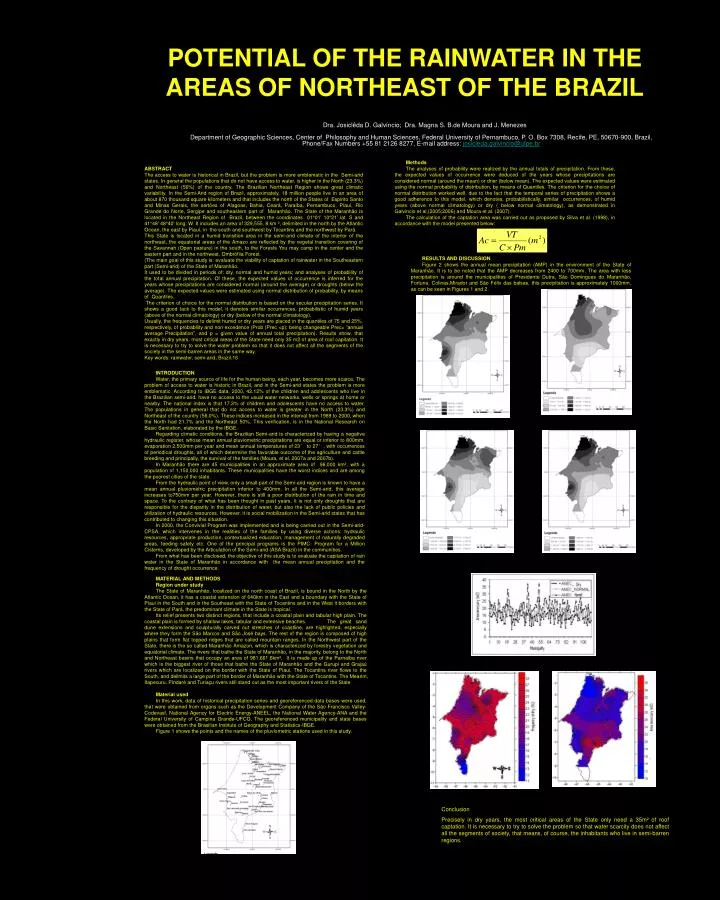
POTENTIAL OF THE RAINWATER IN THE AREAS OF NORTHEAST OF THE BRAZIL. Dra. Josiclêda D. Galvíncio; Dra. Magna S. B.de Moura and J. Menezes. Methods

E N D
POTENTIAL OF THE RAINWATER IN THE AREAS OF NORTHEAST OF THE BRAZIL Dra. Josiclêda D. Galvíncio; Dra. Magna S. B.de Moura and J. Menezes Methods The analyses of probability were realized by the annual totals of precipitation. From these, the expected values of occurrence were deduced of the years whose precipitations are considered normal (around the mean) or drier (below mean). The expected values were estimated using the normal probability of distribution, by means of Quantiles. The criterion for the choice of normal distribution worked well, due to the fact that the temporal series of precipitation shows a good adherence to this model, which denotes, probabilistically, similar occurrences, of humid years (above normal climatology) or dry ( below normal climatology), as demonstrated in Galvincio et al,(2005;2006) and Moura et al. (2007). The calculation of the captation area was carried out as proposed by Silva et al. (1998), in accordance with the model presented below: ABSTRACT The access to water is historical in Brazil, but the problem is more emblematic in the Semi-arid states. In general the populations that do not have access to water, is higher in the North (23.3%) and Northeast (56%) of the country. The Brazilian Northeast Region shows great climatic variability. In the Semi-Arid region of Brazil, approximately, 18 million people live in an area of about 870 thousand square kilometers and that includes the north of the States of Espirito Santo and Minas Gerais, the sertões of Alagoas, Bahia, Ceará, Paraíba, Pernambuco, Piauí, Rio Grande do Norte, Sergipe and southeastern part of Maranhão. The State of the Maranhão is located in the Northeast Region of Brazil, between the coordinates 01°01' 10°21' lat. S and 41°48' 48°40' long. W. It includes an area of 329,555. 8 km ², delimited in the north by the Atlantic Ocean, the east by Piauí, in the south and southwest by Tocantins and the northwest by Pará. This State is located in a humid transition area in the semi-arid climate of the interior of the northeast, the equatorial areas of the Amazo are reflected by the vegetal transition covering of the Savannah (Open pasture) in the south, to the Forests You may camp in the center and the eastern part and in the northwest, Ombrófila Forest. (The main goal of this study is: evaluate the viability of captation of rainwater in the Southeastern part (Semi-arid) of the State of Maranhão. It used to be divided in periods of: dry, normal and humid years; and analyses of probability of the total annual precipitation. Of these, the expected values of occurrence is inferred for the years whose precipitations are considered normal (around the average) or droughts (below the average). The expected values were estimated using normal distribution of probability, by means of Quantiles. The criterion of choice for the normal distribution is based on the secular precipitation series. It shows a good tack to this model, it denotes similar occurrences, probabilistic of humid years (above of the normal climatology) or dry (below of the normal climatology). Usually, the frequencies to delimit humid or dry years are placed in the quantiles of 75 and 25%, respectively, of probability and non excedence (Prob (Prec <p); being changeable Prec= “annual average Precipitation”, and p = given value of annual total precipitation). Results show, that exactly in dry years, most critical areas of the State need only 35 m2 of area of roof capitation. It is necessary to try to solve the water problem so that it does not affect all the segments of the society in the semi-barren areas in the same way. Key words: rainwater, semi-arid, Brazil.16 RESULTS AND DISCUSSION Figure 2 shows the annual mean precipitation (AMP) in the environment of the State of Maranhão. It is to be noted that the AMP decreases from 2400 to 700mm. The area with less precipitation is around the municipalities of Presidente Dutra, São Domingues do Maranhão, Fortuna, Colinas,Mirador and São Félix das balsas, this precipitation is approximately 1000mm, as can be seen in Figures 1 and 2. INTRODUCTION Water, the primary source of life for the human being, each year, becomes more scarce. The problem of access to water is historic in Brazil, and in the Semi-arid states the problem is more emblematic. According to IBGE data, 2000, 42.12% of the children and adolescents who live in the Brazilian semi-arid, have no access to the usual water networks, wells or springs at home or nearby. The national index is that 17.3% of children and adolescents have no access to water. The populations in general that do not access to water is greater in the North (23.3%) and Northeast of the country (56.0%). These indices increased in the interval from 1989 to 2000, when the North had 21.7% and the Northeast 50%. This verification, is in the National Research on Basic Sanitation, elaborated by the IBGE. Regarding climatic conditions, the Brazilian Semi-arid is characterized by having a negative hydraulic register, whose mean annual pluviometric precipitations are equal or inferior to 800mm, evaporation 2,500mm per year and mean annual temperatures of 23° to 27°, with occurrences of periodical droughts, all of which determine the favorable outcome of the agriculture and cattle breeding and principally, the survival of the families (Moura, et al, 2007a and 2007b). In Maranhão there are 45 municipalities in an approximate area of 96,000 km², with a population of 1,150,000 inhabitants. These municipalities have the worst indices and are among the poorest cities of the state. From the hydraulic point of view, only a small part of the Semi-arid region is known to have a mean annual pluviometric precipitation inferior to 400mm. In all the Semi-arid, this average increases to750mm per year. However, there is still a poor distribution of the rain in time and space. To the contrary of what has been thought in past years, it is not only droughts that are responsible for the disparity in the distribution of water, but also the lack of public policies and utilization of hydraulic resources. However, it is social mobilization in the Semi-arid states that has contributed to changing this situation. In 2000, the Convivial Program was implemented and is being carried out in the Semi-arid-CPSA, which intervenes in the realities of the families by using diverse actions: hydraulic resources, appropriate production, contextualized education, management of naturally degraded areas, feeding safety etc. One of the principal programs is the PIMC- Program for a Million Cisterns, developed by the Articulation of the Semi-arid (ASA Brazil) in the communities. From what has been disclosed, the objective of this study is to evaluate the capitation of rain water in the State of Maranhão in accordance with the mean annual precipitation and the frequency of drought occurrence. Department of Geographic Sciences, Center of Philosophy and Human Sciences, Federal University of Pernambuco, P. O. Box 7308, Recife, PE, 50670-900, Brazil, Phone/Fax Numbers +55 81 2126 8277, E-mail address: josicleda.galvincio@ufpe.br MATERIAL AND METHODS Region under study The State of Maranhão, localized on the north coast of Brazil, is bound in the North by the Atlantic Ocean, it has a coastal extension of 640km in the East and a boundary with the State of Piaui in the South and in the Southeast with the State of Tocantins and in the West it borders with the State of Pará, the predominant climate in the State is tropical. Its relief presents two distinct regions, that include a coastal plain and tabular high plain. The coastal plain is formed by shallow lakes, tabular and extensive beaches. The great sand dune extensions and sculpturally carved out stretches of coastline, are highlighted, especially where they form the São Marcos and São José bays. The rest of the region is composed of high plains that form flat topped ridges that are called mountain ranges. In the Northwest part of the State, there is the so called Maranhão Amazon, which is characterized by forestry vegetation and equatorial climate. The rivers that bathe the State of Maranhão, in the majority, belong to the North and Northeast basins that occupy an area of 981,661.6km². It is made up of the Parnaiba river which is the biggest river of those that bathe the State of Maranhão and the Gurupi and Grajaú rivers which are localized on the border with the State of Piaui. The Tocantins river flows to the South, and delimits a large part of the border of Maranhão with the State of Tocantins. The Mearim, Itapecuru, Pindaré and Turiaçu rivers still stand out as the most important rivers of the State Material used In this work, data of historical precipitation series and georeferenced data bases were used, that were obtained from organs such as the Development Company of the São Francisco Valley- Codevasf, National Agency for Electric Energy-ANEEL, the National Water Agency-ANA and the Federal University of Campina Grande-UFCG. The georeferenced municipality and state bases were obtained from the Brasilian Institute of Geography and Statistics-IBGE. Figure 1 shows the points and the names of the pluviometric stations used in this study. Conclusion Precisely in dry years, the most critical areas of the State only need a 35m² of roof captation. It is necessary to try to solve the problem so that water scarcity does not affect all the segments of society, that means, of course, the inhabitants who live in semi-barren regions.