Download
1 / 33
650 likes | 1.46k Views
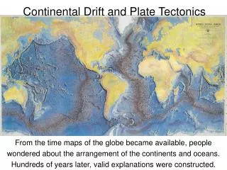
Continental Drift & Plate Tectonics. Continental Drift is the idea that the continents move around on Earth’s surface. The surface of Earth is broken into many pieces like a giant jigsaw puzzle. Plate Tectonics describes how these pieces move on Earth’s surface. Theory of Continental Drift.

E N D
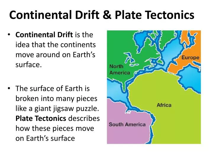
Continental Drift & Plate Tectonics • Continental Drift is the idea that the continents move around on Earth’s surface. • The surface of Earth is broken into many pieces like a giant jigsaw puzzle. Plate Tectonics describes how these pieces move on Earth’s surface
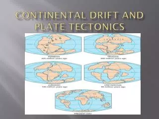
Theory of Continental Drift • The theory that continents were once connected, but have drifted apart
Alfred Wegener • Alfred Wegener was a German climatologist and arctic explorer who suggested the idea of continental drift. • He thought the continents we know today had once been part of an earlier “supercontinent”. • He called this great landmass Pangaea.
Evidence for Continental Drift • Coal beds stretch across the eastern U.S. and continue across southern Europe. • Matching plant fossils are found in South America, Africa, India, Australia, and Antarctica. • Matching reptile fossils are found in South America and Africa. • Matching early mammal fossils are found in South America and Africa.
Fossil Evidence • Impressions of organisms left in rock layers that indicate the organisms once lived in the area Matching rock types and mountain belts occur in North America and the British Isles, and Africa and South America. Evidence of glaciers is present in regions with warm, dry climates. Continents that are close to the equator today were once closer to the South Pole in the distant past
Plate Tectonic Theory • Theory that the lithosphere is divided into tectonic plates that slowly move on top of the asthenosphere
Sea Floor Spreading • American geophysicist Harry Hess helped develop the theory of plate tectonics. • While a Navy officer, Hess helped map the ocean floor. • Hess called his hypothesis sea-floor spreading.
Undersea Mountains discovered • Naval maps showed undersea mountain chains that formed a continuous chain down the centers of ocean floors • Hess wondered if new ocean floor was created at these mid-ocean ridges.
Harry Hess’ Idea • As new sea floor is made at mid-ocean ridges, the continents are pushed away.
Sea Floor Spreading Evidence • A parallel pattern of rock material found at identical locations on each side of the Mid-Atlantic Ridge reveals rock of the same geologic age and polarity • The key was the discovery that there are “magnetic patterns” in the rocks on either side of the mid-ocean ridges. Reversed polarity Normal polarity
Lithosphere • Cool, rigid, outermost layer of Earth that is divided into enormous pieces called tectonic plates; consists of the crust and the rigid uppermost part of the mantle
Moving pieces of the Lithosphere • There are two kinds of lithospheric plates: oceanic plates and continental plates Andesite, Granite, and Basalt are all igneous rocks. Basalt is a much denser igneous rock than Andesite or Granite, so oceanic crust is more dense than continental crust.
Mantle Convection • Convection cells in Earth’s lower mantle drive the lithospheric plates on the surface. • Heated lower mantle material rises toward Earth’s surface. • Then, cooling makes the nearby material denser and it sinks deeper into the lower mantle. This sinking process is called subduction.
Hot Spots and Island Chains • A single hot rising plume, called a mantle plume, can cause a volcanic eruption in the plate above it. • If the eruption is strong and lasts long enough, the volcanic eruption may form an island on the plate.
Hot Spots and Island Chains • After the island forms, the movement of the plate carries it away from the mantle plume. • Scientists determine the direction and speed of plate movement by measuring these island chains.
Plate Boundaries • There are 3 types of plate boundaries.
Divergent Boundary Great Rift Valley in Africa • The boundary between two tectonic plates moving away from each other; on land creates rift valleys, on the sea floor creates new ocean crust Mid-Ocean Ridge
Divergent Plate Boundaries • Divergent boundaries are found in the ocean as mid-ocean ridges. • A divergent boundary is the line between two plates where they are moving apart. • This type of boundary is found over the rising plume of a mantle convection cell.
Divergent Boundaries • Divergent boundaries can also be found on continents as rift valleys. • When a rift valley forms on land, it may eventually split the landmass.
Convergent Plate Boundaries • Convergent Plate Boundaries are where two plates come together. • When continental plates collide, mountains are formed. • When an oceanic and continental plate collide, the denser oceanic plate subducts under the less dense continental plate. • When oceanic plates collide, one subducts under the other, forming a trench.
Convergent Boundary with Mountain Building • A major geological event; occurs when continental plates of equal density converge Continental plate Continental plate CrustCrust Lithosphere Asthenosphere
Convergent Boundary with Subduction • The boundary between two tectonic plates moving toward each other resulting in volcanic activity when a denser ocean plate subducts below a less dense continental plate Volcanic mountain range Some oceanic crust melts and forces its way upward
Subduction Subduction Zone • A plate is forced below when one plate is denser than another as they converge; occurs at continental to oceanic boundaries and oceanic to oceanic boundaries Note the formation of a trench in the Subduction Zone
Collision of Nazca and South American Plates • As the oceanic Nazca Plate collides with the continental South American Plate, the denser Nazca Plate subducts under the South American Plate. • The resulting surface feature is the Andes Mountain range.
Subduction Zones & Volcanic Activity • Volcanoes often occur at subduction zones
Convergent Boundaries and Mountains • Mountain ranges are formed when continents collide.
Formation of the Himalaya Mountains • The formation of the Himalaya Mountains is attributed to the collision of the Indo-Australian Plate with the Eurasian Plate
Transform Boundary • The boundary between two plates that slide past one another; the release of stored energy result in sudden shifts often causing major geological events such as earthquakes
Transform Boundaries • An edge of a lithospheric plate that slides by another plate is called a transform plate boundary, sometimes called a transform fault.
Transform Plate (Fault) Boundary • A good clue for locating transform boundaries is offsetting. • When seen from above, the feature appears to make a zig-zag.
Earth’s Largest Lithospheric Plates • Although Earth’s crust it “broken” into many lithospheric (tectonic) plates, there are 7 major plates, shown below.