Download
1 / 19
190 likes | 321 Views
SocDic Conference. Long-Term Operation of Landslide Observation System Using ZigBee Modules. University of Tsukuba Geo-Sensing Lab Wang Rui. Contents. 1. 3. 2. 5. 4. About landslide. Conclusion. Our new system. Landslide observation system. About ZigBee. About landslide.

E N D
SocDic Conference Long-Term Operation of Landslide Observation System Using ZigBee Modules University of Tsukuba Geo-Sensing Lab Wang Rui
Contents 1 3 2 5 4 About landslide Conclusion Our new system Landslide observation system About ZigBee
About landslide • What is landslide? • A landslide is a geological phenomenon that rocks, earth, or debris flows on slopes due to gravity. Landslide can occur in any kind of terrain given the right conditions of soil, moisture and the angle of slope. Fig1. El Salvador.2001
About landslide Landslide in Japan and Indonesia West Java, 2010 Landslide in Japan Landslide observation System is very important and strongly needed western Sumatra , 2009 Fig2. Landslide in Indonesia and Japan
Landslide observation System Function of the Landslide observation System Landslide observation system Landslide monitoring Landslide warning • Effective measures for landslide. • Necessary to measure before occurring landslide. Target of measurement • Displacement surface of the ground • Displacement in the ground • Water level in the ground • Amount of rainfall
Landslide observation System Current landslide observation system • Wired system • Wireless system • other wireless standards • → narrow observation area • → Power is problem • → If many nodes, high cost Fig3. Wired monitoring system • wired observation system • → breaking of wire • → high-cost Fig4. Wireless monitoring system
Landslide observation System Our system Based on ZigBee technology Fig5. Landslide observation system using ZigBee Advantage • Fast installation(no drilling is necessary) • Higher stability(no cables break) • Data transmission is real-time • Permanent data transmission and data collection • Power saving(ZigBee device sleeping mode)
About ZigBee What is ZigBee ? • ZigBee is a Ad-hoc networking technology • Based On IEEE 802.15.4 standard • Intended for 2.45 GHz , 868 MHz and 915 MHz Band. • Low in cost ,complexity & power consumption • Data rates touch 250Kbps for 2.45Ghz, 40 Kbps 915Mhz and 20Kbps for 868Mhz band. Fig6. ZigBee device Advantage • Network capacity • Low power consumption • Low cost • Bought freely
About ZigBee Table1. Comparison with other wireless communication standards Zigbee is especially suitable for instrument measurement and control
INDUSTRIAL & COMMERCIAL About ZigBee ZigBee Application TV VCR DVD/CD remote CONSUMER ELECTRONICS monitors sensors automation control ZigBee LOW DATA-RATE RADIO DEVICES PC & PERIPHERALS PERSONAL HEALTH CARE TOYS & GAMES HOME AUTOMATION consolesportables educational security HVAC lighting closures
About ZigBee ZigBee Flexible network topology Star Cluster tree Mesh Fig7. Network topology
Our new system network topology : mesh Fig8. working process Fig9. Network of our system
Our new system System component • GeoSense: • Network operations • Communicate external device • State transition • GeoSense Coordinator: • Formation of networks • Control GeoSense • AirSenseWare (software): • Control GeoSenseCoordinator • Monitor network • Collect and record data GeoSense Coordinator GeoSense Fig10. GeoSense Fig9. Outline of system
Our new system Problem using mesh network GeoSense Coordinator To work as ZigBee-Router, loss of original power-saving GeoSense • Normal ZigBee device: • can not be set into sleeping mode when • using mesh network • Our laboratory’s ZigBee device(GeoSense): • can be set into sleeping mode when using mesh network Fig10. GeoSense Improve Power-Saving of ZigBee is important for this study Our ZigBee system’s working time is much longer.
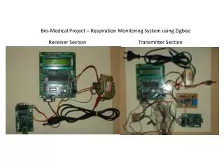
Our new system Experiment of Small-Scale System • System component • AirSense Ware (1) • GeoSense Coodinator (1) • GeoSense (4) • GeoSense with external measurement device(1) • Network topology • Mesh topology External measurement device Fig12. Experiment network Fig11. Small-scale system
Our new system Fig13. Implementation and equipment of landslide observation system • Get environment data • Temperature ,water level , slope • Number of measurement • 72times • Measurement time • A day
Our new system Fig14. Accumulated environmental data • Measure three times per hour properly • Confirmed the power saving function works properly • Get various environment data ,such as temperature and water level , slope , etc to change sensor
Our new system Conclusion • Landslide observation system is very useful for both Japan and Indonesia. • ZigBee is muchsuitable for Landslide observation system • GeoSense can be set into sleeping mode when using mesh network. It is more power-saving. • Many types of data can be obtained for landslide early warning