Download
1 / 15
210 likes | 1.34k Views
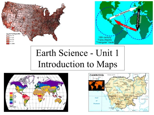
Earth Science Maps Gentri Pitts January 6, 2011 CEC WD2. Table of Contents. Continents Oceans Latitude and Longitude Climate Zones and Latitude Global Winds Nike Shoe Investigation Nike Shoe Investigation Map. Continents. Greenland. Asia. North America. Africa. South America.

E N D
Earth Science Maps Gentri Pitts January 6, 2011 CEC WD2
Table of Contents • Continents • Oceans • Latitude and Longitude • Climate Zones and Latitude • Global Winds • Nike Shoe Investigation • Nike Shoe Investigation Map
Continents Greenland Asia North America Africa South America Australia Antarctica
Oceans Arctic Ocean Atlantic Ocean Pacific Ocean Indian Ocean Southern Ocean
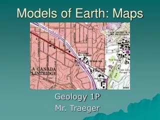
Latitude & Longitude 1. Draw a red line along the equator (0 degrees latitude). 2. Draw a purple line along the Prime Meridian (0 degrees longitude). 3. In which ocean is the location 10 degrees S latitude, 75 degrees E longitude located? Mark it on the map with a blue "X" and write the name of the ocean. 4. In which ocean is the location 30 degrees N latitude, 60 degrees W longitude located? Mark it on the map with a blue "Y" and write the name of the ocean.
Latitude & Longitude Cont. MU. Mumbai: 19°N, 72°ENA. Nairobi: 1°S, 37°ENO. New Orleans: 30°N, 90°WNY. New York: 40°N, 74°WR, Rio de Janeiro: 23°S, 43°WSE. Seattle: 47°N, 122°WSY. Sydney: 34°S, 151°ETK. Tokyo: 35°N, 139°ET. Toronto: 43°N, 79°WT. Toronto: 43°N, 79°W 5. Mark the following cities on the map in red: B. Beijing: 40°N, 116°EC. Cairo: 30°N, 31°ECT. Cape Town: 34°S, 18°EH. Hong Kong: 22°N, 114°EJ. Jakarta: 6°S, 106°ELA. Los Angeles: 34°N, 118°WLI. Lima: 12°S, 77°WLO. London: 51°N, 0°WMC. Mexico City: 19°N, 99°W MO. Moscow: 55°N, 37°E
Climate Zones and Latitudes Polar (Arctic) Zone: 66.5°N-90°N Temperate Zone: 23.5°N- 66.5°N Tropic Zone: 23.5°N- 23.5°S Temperate Zone: 23.5°S- 66.5°S Polar (Arctic) Zone: 66.5°S-90°S
Global Winds Polar Cells Polar Easterlies Ferrill Cell 60° N Sinking Air Westerlies 30° N Trade Winds Rising Air 0° Hadley Cells 30° S Westerlies Westerlies Westerlies Westerlies 60° S Polar Easterlies http://www.ucar.edu/learn/images/fastcirc.gif
Nike Shoe Investigation 1. 5. 8. 3. 2. 4. 6. 7. 9. 10. 11.
W Nike Shoe Instigation (contd.) E N. Pacific 5, 3. Kuroshio 1. 2. California 8. 4. 6. 11. 10. 7. 9. N. Equatorial
ANALYSIS OF DATA: 1- Define these terms: (a) gyre:a large system of rotating ocean currents (b) current: a continuous, directed movement of ocean water generated by the forces acting upon it, (ie: gravity, salinity, etc.) (c) eddy: the swirling of a fluid and the reverse current created when the fluid flows past an obstacle. 2- By looking at the data you plotted on your map, write a sentence or two describing the general shape of the route or pathway taken by the drifting shoes. The path of the shoes was in a circular, rotating motion such as a current. 3- Write a few sentences EXPLAINING this pathway using appropriate terms from #1 above. The shoes followed the North Pacific Current, which is part of a gyre. The path of the shoes went in a circle because the current rotated in a circle, starting off the coast of Asia, going to Alaska, halfway down the coast of American West Coast, and circling through the ocean and Hawaii, and back to Asia. Nike Shoe Investigation
4- Using an atlas or other reference showing the major surface currents in the Pacific Ocean, (a) List the names for each of the currents that affected the distribution of the shoes, and: The North Pacific Current, California Current, North Equatoral Current, and Kurishio Current. (b) write them on you map showing their correct location. Nike Shoe Investigation (contd.)
5- Using a more detailed map or an atlas showing the Pacific Ocean with a distance scale, calculate approximately how far the shoes traveled between the point where they spilled and their first landfall. The shoes likely went about a thousand miles before they reached landfall. 6- Considering the distance you figured in #5, and the time it took for the shoes to make their first landfall, (a) What was the speed of the current moving those shoes in kilometers per day? (b) miles per day? (c) kilometers per hour? (d) miles per hour? 7- Calculate approximately how far the shoes traveled between California and Hawaii. Extra Credit
8- Considering the distance you figured in #6, and the time it took for the shoes to move from California to Hawaii (a) Whatwas the speed of the current moving those shoes in kilometers per day? (b) miles per day? (c) kilometers per hour? (d) milesper hour? 9- Name the two surface currents you have been studying in the above questions. 10- Based on your calculations, rank the two surface currents according to their speed. 11- Based on the average speed of the two currents, how long would it take for plankton drifting off the coast of San Francisco reach Santa Monica Bay Extra Credit (contd.)