Download
1 / 2
20 likes | 128 Views
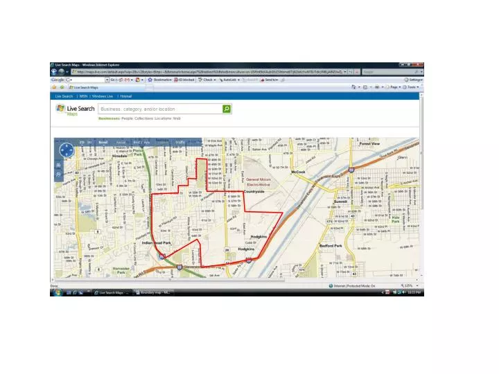
LYONS TOWNSHIP LITTLE LEAGUE BOUNDARIES. The Lyons Township Little League includes the following areas: LaGrange Highlands – All including the LaGrange Country Club Western Springs - West of Wolf Road and south of 55 th Street Indian Head Park – North of Joliet Road Hodgkins – All

E N D
LYONS TOWNSHIP LITTLE LEAGUE BOUNDARIES The Lyons Township Little League includes the following areas: • LaGrange Highlands – All including the LaGrange Country Club • Western Springs - West of Wolf Road and south of 55th Street • Indian Head Park – North of Joliet Road • Hodgkins – All • LaGrange – Country Club Drive, Calle View Drive and the west side of Brainard Avenue • Countryside – All north of Joliet Road. The section south of Joliet Road and east of Blackstone Avenue including LaGrange Meadows Trailer Court and the Forest Villa Apartments and Condominiums The boundaries of Lyons Township Little League are as follows: • Starting at the corner of East Avenue and 55th Street • West on 55th Street to Brainard Avenue • North on Brainard to the north border of the LaGrange Country Club (48th Street) • West on 48th Street to Edgewood Avenue (west border of LaGrange Country Club) • South on Edgewood Avenue to approximately 52nd Street (south end of Hospital property) • West on 52nd Street to Gilbert Avenue/Willow Springs Road • South on Gilbert/Willow Springs Road to the property lines between 53rd Street and 54th Street • West along 53rd/54th Street property lines to Howard Avenue property lines • South along Howard Ave property lines to 55th Street • West on 55th Street to Interstate 294 • South along Interstate 294 to Joliet Road • East on Joliet Road to approximately Blackstone Avenue or the rear property line of homes on Stalford Road along the west border of LaGrange Meadows trailer park • South to Forest Reserve boundary • West to Forest Reserve boundary • South along Forest Reserve boundary to Interstate 55 • East along Interstate 55 to River Road • Northeast on River Road then west following the Hodgkins city border back to East Avenue • North on East Avenue ending at the corner of East Avenue and 55th Street