Download
1 / 1
10 likes | 153 Views
M9.0. CHIBA. Issued on 11 March 2011. Continuous. Tsunami warning. 1m. Traces of seashell in boiled sand. M9.0. CHIBA. TOKYO. NARITA AIRPORT. “A Bridge over another Bridge”. Thickness at the origin: 15-20cm. Sand boils. Tokyo Disneyland. 0 km. 5. 10. Water level.

E N D
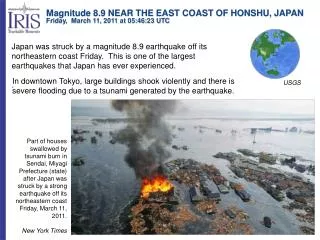
M9.0 CHIBA Issued on 11 March 2011 Continuous Tsunami warning 1m Traces of seashell in boiled sand M9.0 CHIBA TOKYO NARITA AIRPORT “A Bridge over another Bridge” Thickness at the origin: 15-20cm Sand boils Tokyo Disneyland 0km 5 10 Water level Ground Displacement along southern levee of Tone River Liquefaction Embankment subsidence Tsunami Damage Location map of Chiba Coastal protections are designed to resist wave action 1m Coastal protection remained safe as compared to roads 2m Force of Tsunami is higher when it flows back to the sea Unforeseen uplifting of man holes near Disneyland Sand boils The “Otori” performed well like the piers of bridge 0.5m “Devastation of coastal town” Partially submerged ship in shallow waters near the beach Ships floated over the docks Few signs of liquefaction near Narita Airport area Scenes at harbor and beach Reconnaissance in Chiba after “The 2011 off the Pacific coast of Tohoku Earthquake” Mohsin U. Qureshi and Ikuo Towhata Department of Civil Engineering, The University of Tokyo, Tokyo, Japan. 東京大学 April 3-8, 2011 Vienna, Austria 4. Ground displacement 1. Introduction 3. Liquefaction 2. Tsunami A reconnaissance was made in Chiba (prefecture lies next to Tokyo in NE) after a massive earthquake of magnitude 9.0 on 11 March 2011, 14:46 JST, off the Pacific coast of the northeastern part of the Japanese Archipelago which also raised a devastating tsunami. Epicenter is located at 38.322°N, 142.369°E, which is 373km NE of Tokyo. This magnitude places the earthquake as the fourth largest in the world since 1900 and the largest in Japan since modern instrumental recordings began 130 years ago. Tsunami warning followed the earthquake whose height exceed 10m in northeastern coasts of Japan. Chiba was also highly affected by the tsunami. As a consequence of liquefaction, marks of sand boils, subsidence, uplifting of manholes and ground cracks were observed. Infact the shaking was not too strong but its frequency was too high. Widespread liquefaction in some areas can be inferred to; 1) located on reclaimed land, 2) historically rivers were flowing through that area, 3) shallow ground water table. Pictures shown here were taken on 13th and 14th of March, 2011 An interesting example of continuous horizontal ground displacement was observed on the levees of Tone River. The beams supporting the side walls of a drain running parallel to the levee were failed due to the subsidence of levee as illustrated below. The hydraulic structures along the river showed no damage. 5. Concluding remarks • After such an extreme experience of disaster, future research of Geotechnical Engineering has been provoked, few remarks are as follow, however many to come; • Revision in Ground improvement techniques as a countermeasure against liquefaction. • Extreme scenario of tsunami should be envisioned for urbanization along the coast. • A huge disaster left with directions to improve our efforts in tackling with natural disaster. Survey was conducted with objectives to collect information about the type of damage with respect to the location of area. The authors focused on the following points; • Tsunami devastation in coastal areas • Widespread liquefaction on reclaimed land • Embankment subsidence along the river 6. References • Japan meteorological agency • http://www.jma.go.jp/jma/indexe.html • April Issue of ISSMGE Bulletin 2011 • http://www.issmge.org/web/page.aspx?refid=430 CONTACT: Mohsin Usman Qureshi (Ph. D. Student) Geotechnical Engineering Laboratory, Department of Civil Engineering, The University of Tokyo 7-3-1, Hongo, Bunkyo-ku, 113-8656, Tokyo, JAPAN , Email: qureshi@geot.t.u-tokyo.ac.jp