Download
1 / 17
170 likes | 356 Views
Section 1: Finding Locations on Earth. Preview Objectives Latitude Longitude Comparing Latitude and Longitude Great Circles Finding Direction. Objectives. Distinguish between latitude and longitude. Explain how latitude and longitude can be used to locate places on Earth’s surface.

E N D
Section 1: Finding Locations on Earth Preview Objectives Latitude Longitude Comparing Latitude and Longitude Great Circles Finding Direction
Objectives • Distinguishbetween latitude and longitude. • Explainhow latitude and longitude can be used to locate places on Earth’s surface. • Explainhow a magnetic compass can be used to find directions on Earth’s surface.
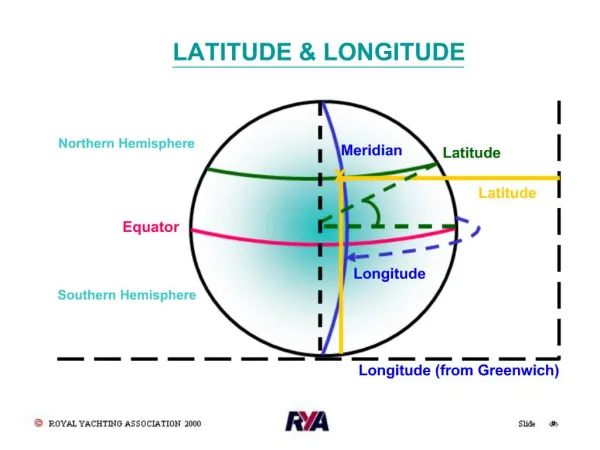
Latitude • The points at which Earth’s axis of rotation intersects Earth’s surface are used as reference points for defining direction. These points are the geographic North Pole and South Pole. • Halfway between the poles, a circle called the equator divides Earth into the North and Southern Hemispheres. • A reference grid that is made up of additional circles is used to locate places on Earth‘s surface.
Latitude, continued • One set of circles describes positions north and south of the equator. These circles are known as parallels, and they express latitude. • parallel any circle that runs east and west around Earth and tat is parallel to the equator; a line of latitude • latitudethe angular distance north or south from the equator; expressed in degrees
Latitude, continued The diagram below shows Earth’s parallels.
Latitude, continued Degrees of Latitude • Latitude is measured in degrees, and the equator is 0° latitude. The latitude of both the North Pole and the South Pole is 90°. • In actual distance, 1° latitude equals about 111 km. Minutes and Seconds • Each degree of latitude consists of 60 equal parts, called minutes. One minute (symbol: °) of latitude equals 1.85 km. • In turn, each minute is divided into 60 equal parts, called seconds (symbol: °).
Longitude • East-west locations are established by using meridians. • meridianany semicircle that runs north and south around Earth from the geographic North Pole to the geographic South Pole; a line of longitude • longitudethe angular distance east or west from the prime meridian; expressed in degrees
Longitude, continued The diagram below shows Earth’s meridians.
Longitude, continued Degrees of Longitude • The meridian that passes through Greenwich, England is called the prime meridian. This meridian represents 0° longitude. • The meridian opposite the prime meridian, halfway around the world, is labeled 180°, and is called the International Date Line. Distance Between Meridians • The distance covered by a degree of longitude depends on where the degree is measured. The distance measured by a degree of longitude decreases as you move from the equator toward the poles.
Great Circles • A great circle is any circle that divides the globe into halves, or marks the circumference of the globe. • Any circle formed by two meridians of longitude that are directly across the globe from each other is a great circle. • The equator is the only line of latitude that is a great circle. • The route along a great circle is the shortest distance between two points on a sphere. As a result, great circles are commonly used in navigation, such as for air and sea routes.
Great Circles, continued The diagram below shows what a great circle is.
Great Circles, continued Reading Check Why is the equator the only parallel that is a great circle? Because the equator is the only parallel that divides Earth into halves
Finding Direction • One way to find direction on Earth is to use a magnetic compass. • A magnetic compass can indicate direction because Earth has magnetic properties as if a powerful bar-shaped magnet were buried at Earth’s center at an angle to Earth’s axis of rotation. • The areas on Earth’s surface just above where the poles of the imaginary magnet would be are called the geomagnetic poles. • The geomagnetic poles and the geographic poles are located in different places.
Finding Direction, continued Magnetic Declination • The angle between the direction of the geographic pole and the direction in which the compass needle points is called magnetic declination. • In the Northern Hemisphere, magnetic declination is measured in degrees east or west of the geographic North Pole. • Because Earth’s magnetic field is constantly changing, the magnetic declinations of locations around the globe also change constantly. • By using magnetic declination, a person can use a compass to determine geographic north for any place on Earth.
Finding Direction, continued The diagram below shows the magnetic declination of the United States.
Finding Direction, continued The Global Positioning System • Another way people can find their location on Earth is by using the global positioning system, or GPS. • GPS is a satellite navigation system that is based on a global network of 24 satellites that transmit radio signals to Earth’s surface. • A GPS receiver held by a person on the ground receives signals from three satellites to calculate the latitude, longitude, and altitude of the receiver on Earth.