Download
1 / 2
20 likes | 82 Views

E N D
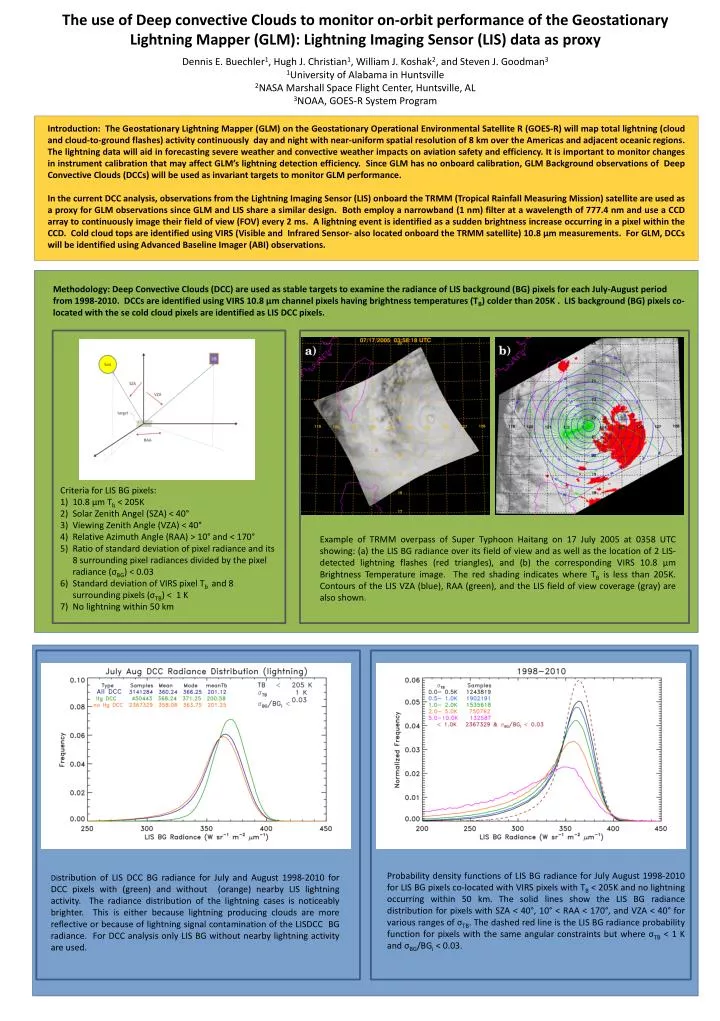
Introduction: The Geostationary Lightning Mapper (GLM) on the Geostationary Operational Environmental Satellite R (GOES-R) will map total lightning (cloud and cloud-to-ground flashes) activity continuously day and night with near-uniform spatial resolution of 8 km over the Americas and adjacent oceanic regions. The lightning data will aid in forecasting severe weather and convective weather impacts on aviation safety and efficiency. It is important to monitor changes in instrument calibration that may affect GLM’s lightning detection efficiency. Since GLM has no onboard calibration, GLM Background observations of Deep Convective Clouds (DCCs) will be used as invariant targets to monitor GLM performance. In the current DCC analysis, observations from the Lightning Imaging Sensor (LIS) onboard the TRMM (Tropical Rainfall Measuring Mission) satellite are used as a proxy for GLM observations since GLM and LIS share a similar design. Both employ a narrowband (1 nm) filter at a wavelength of 777.4 nm and use a CCD array to continuously image their field of view (FOV) every 2 ms. A lightning event is identified as a sudden brightness increase occurring in a pixel within the CCD. Cold cloud tops are identified using VIRS (Visible and Infrared Sensor- also located onboard the TRMM satellite) 10.8 µm measurements. For GLM, DCCs will be identified using Advanced Baseline Imager (ABI) observations. Methodology: Deep Convective Clouds (DCC) are used as stable targets to examine the radiance of LIS background (BG) pixels for each July-August period from 1998-2010. DCCs are identified using VIRS 10.8 µm channel pixels having brightness temperatures (TB) colder than 205K . LIS background (BG) pixels co-located with the se cold cloud pixels are identified as LIS DCC pixels. The use of Deep convective Clouds to monitor on-orbit performance of the Geostationary Lightning Mapper (GLM): Lightning Imaging Sensor (LIS) data as proxy Dennis E. Buechler1, Hugh J. Christian1, William J. Koshak2, and Steven J. Goodman31University of Alabama in Huntsville2NASA Marshall Space Flight Center, Huntsville, AL3NOAA, GOES-R System Program • Criteria for LIS BG pixels: • 10.8 µm Tb < 205K • Solar Zenith Angel (SZA) < 40° • Viewing Zenith Angle (VZA) < 40° • Relative Azimuth Angle (RAA) > 10° and < 170° • Ratio of standard deviation of pixel radiance and its 8 surrounding pixel radiances divided by the pixel radiance (σBG) < 0.03 • Standard deviation of VIRS pixel Tb and 8 surrounding pixels (σTB) < 1 K • No lightning within 50 km Example of TRMM overpass of Super Typhoon Haitang on 17 July 2005 at 0358 UTC showing: (a) the LIS BG radiance over its field of view and as well as the location of 2 LIS-detected lightning flashes (red triangles), and (b) the corresponding VIRS 10.8 µm Brightness Temperature image. The red shading indicates where TB is less than 205K. Contours of the LIS VZA (blue), RAA (green), and the LIS field of view coverage (gray) are also shown. Probability density functions of LIS BG radiance for July August 1998-2010 for LIS BG pixels co-located with VIRS pixels with TB < 205K and no lightning occurring within 50 km. The solid lines show the LIS BG radiance distribution for pixels with SZA < 40°, 10° < RAA < 170°, and VZA < 40° for various ranges of σTB. The dashed red line is the LIS BG radiance probability function for pixels with the same angular constraints but where σTB < 1 K and σBG/BGi < 0.03. Distribution of LIS DCC BG radiance for July and August 1998-2010 for DCC pixels with (green) and without (orange) nearby LIS lightning activity. The radiance distribution of the lightning cases is noticeably brighter. This is either because lightning producing clouds are more reflective or because of lightning signal contamination of the LISDCC BG radiance. For DCC analysis only LIS BG without nearby lightning activity are used.
Location of LIS DCC BG pixels with and without nearby lightning activity Location of LIS observed deep convective clouds for LIS BG pixels that had lightning occurring within 50 km. The South Atlantic Anomaly (SAA) region is shown since LIS background images in and near this region are suppressed due to the high noise rate encountered here. There is a greater percentage of LIS BG pixels over land than over ocean when compared to the no lightning case. Location of LIS observed DCCs for LIS BG pixels that had no lightning occurring within 50 km. These occur mainly over the oceans, especially over the Tropical Western Pacific, the East Indian Ocean and oceanic regions near Central America. These are the DCC used in the analysis. Distribution of LIS DCC BG radiance for July and August 1998-2010. The distributions are very similar for each year indicating little to no degradation during the period. Yearly values of mean LIS DCC BG radiance for each combined July and August period from 1998-2010. The maximum departure from the mean (0.8%) occurs during 2000. • Conclusions: • The DCC analysis of the LIS BG indicates no discernible degradation of instrument performance from 1998-2010. • Because of its similar design, the GLM should also experience little performance degradation. • The DCC technique can be used to monitor GLM instrument performance once in orbit. • References: • Buechler, D. E., W. J. Koshak; H. J. Christian; and S. J. Goodman, 2012: Assessing the performance of the Lightning Imaging Sensor (LIS) using Deep Convective Clouds, Atmos. Res. http://dx.doi.org/10.1016/j/atmosres.2012.09.008. • Doelling, D.R., L. Nguyen, and P. Minnis, 2004: On the use of deep convective clouds to calibrate AVHRR data. Earth Observing Systems IX, W.L. Barnes and J.J. Butler, Eds., International Society for Optical Engineering (SPIE Proceedings, Vol. 5542), doi:10.1117/12.560047. • Doelling, D.R., G. Hong, D. Morstad, R. Bhatt, A. Gopalan, X. Xiong, 2010: The characterization of deep convective cloud albedo as a calibration target using MODIS reflectances. Proc., SPIE Int. Soc. Opt. Eng., 7862, 78620I, doi:10.1117/12.869577. • Hu, Y., B.A. Wielicki, P. Yang, P.W. Stackhouse, B. Lin, D. Young, 2004: Application of deep convective cloud albedo observations to satellite-based study of terrestrial atmosphere: Monitoring stability of space-borne instruments and assessing absorption anomaly. IEEE Trans. Geosci. Remote Sens., 42, 2594-2599. • Sohn, B.-J. and S.-H. Ham, 2009: Possibility of visible-channel calibration using deep convective clouds overshooting the TTL. J. Appl. Meteor. Climatol., 48, 2271-2283. The observed angular distribution of mean LIS DCC BG radiance is being used to derive an angular distribution model (ADM) to correct for anisotropy effects.