Download

1 / 23
240 likes | 485 Views
NCEP Regional Reanalysis NARR Glenn K. Rutledge NOMADS PI NESDIS Data Archive Board Briefing 17 March 2004 . Briefing Overview. NARR Informational Briefing NARR Overview Improvements over Global Reanalysis Domain / Resolution / Frequency NCDC NARR: Ingest/Archive/Access.

E N D
NCEP Regional ReanalysisNARRGlenn K. RutledgeNOMADS PI NESDIS Data Archive Board Briefing 17 March 2004
Briefing Overview • NARR Informational Briefing • NARR Overview • Improvements over Global Reanalysis • Domain / Resolution / Frequency • NCDC NARR: Ingest/Archive/Access
North American Regional Reanalysis (NARR): Background • The NARR is an improved long term re-analysis of basic meteorological fields on a high resolution gird, that for the first time on any scale, includes precipitation. • NCDC has agreed to archive most of these new data. • This is an informational briefing for the DAB for • NARR availability with background information • Provide access information
NARR: Purpose • Create a long-term set of consistent climate data on a regional scale on a North American domain • Superior to NCEP/NCAR Global Reanalysis (GR) due to: • use of a regional model (the Eta model) • Advances in modeling and data assimilation since 1995, especially: • Precipitation assimilation • Direct assimilation of radiances • Land-surface model updates
ETA / NOAH LAND-SURFACE MODEL UPGRADES: • - Assimilation of Hourly Precipitation • -- hourly 4-km radar/gage analysis (Stage IV) • Cold Season Processes (Koren et al 1999) -- patchy snow cover -- frozen soil (new state variable) -- snow density (new state variable) • - Bare Soil Evaporation Refinements • -- parameterize upper sfc crust cap on evap • - Soil Heat Flux -- new soil thermal conductivity • (Peters-Lidard et al 1998) -- under snowpack (Lunardini, 1981) -- vegetation reduction of thermal cond. • - Surface Characterization-- maximum snow albedo database • (Robinson & Kukla 1985) -- dynamic thermal roughness length • refinements • - Vegetation • -- deeper rooting depth in forests • -- canopy resistance refinements
180 km 80 km 32 km
NARR Results: Upper-Air • Compared both GR and RR against fits to raobs • Root-mean-square (RMS) analysis fits significantly better for temperatures and vector wind speeds • Wind speed improvement greatest in the upper troposphere, especially in winter • First guess (3-hr forecast, pre-3DVAR) temperatures not always as favorable for RR compared to GR • Relative humidity improved for RR for both analysis and first guess
NARR Results: Near Surface • First guess, 1997: for temperatures, comparison against ship/buoy only. Surface temperature RMS improved both in winter and in summer • 1998: Surface temperatures RMS favorable for NARR in both winter and summer. RR biases closer to zero and little diurnal variation problem in summer • 10-m winds: RMS in NARR neither better nor worse compared to GR (remarkably similar!) • Slow wind biases improved in NARR: just a little in winter, visibly in summer
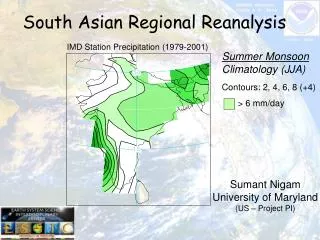
NARR Results: Precipitation • Several sources of precipitation • CONUS data with PRISM (Mountain Mapper) to improve orographic effects • Canada • Mexico • CMAP (combination of satellite and gauge data) over oceans; CMAP is blocked: • Near central areas of hurricanes (7.5 by 7.5 deg) • Observed precipitation > 100 mm/day • A 15-degree “blending belt” between 27.5 and 42.5 N, with no CMAP north of 42.5 N
NARR Results: Precipitation (cont) • Precipitation observations used to prescribe the latent heat profile in Eta • Model uses given latent heat profile to simulate precipitation • Resulting precipitation pattern looks very much like the observed precipitation pattern in both summer and winter
NARR: Analysis System • Precipitation assimilation in EDAS • Revised 3DVAR to run using the satellite bias corrections for all the satellites • Updated the RR’s land-surface model • Ported the RR pilot system from the SGI Origin 3000 to the IBM-SP
NARR: System Design • Fully cycled 3-hr EDAS • Lateral boundary conditions supplied by GR2 • Forecasts to 72 hr every 2.5 days, using GR2 forecast boundary conditions • Resolution: 32-km, 45 layers • NARR time period: 1979-2003 Updated monthly
NARR: Data Acquisition and Processing • Acquired precipitation dataset with use of PRISM (Mountain Mapper); disaggregated data to hourly • Acquired TOVS-1B data for 1979-1997 time period • Acquired Air Force snowdepth dataset • Created a high-resolution sea-ice field
NARR: Archiving Overview • Several archiving centers • National Climatic Data Center (10TB) • National Centers for Atmospheric Research * • San Diego Supercomputing Center ** • Perhaps University of Maryland • * 7TB • ** Ambitious amounts
NARR: Archive Data Volumes Archive a) and b) only: 7.8TB + 2.2TB of restart= 10TB AWIPS Grid 221 a) analysis files 52 Mb single file 420 Mb daily (8 times per day, every 3 hr) 12.6 Gb monthly 151 Gb yearly 3.7 Tb entire RR period (25 years) b) 3-hour first-guess forecast files 58 Mb single file 464 Mb daily (8 times per day, every 3 hr) 14 Gb monthly 168 Gb yearly 4.1 Tb entire RR period (25 years) c) Restart files 265 Mb single file 4.1 Gb daily (16 files per day; 8 analysis and 8 first-guess files, every 3 hr) 130 Gb monthly 1.5 Tb yearly 37 Tb entire RR period (25 years)
NCDC: Data Ingest and Archive • 10TB on HDSS and 7.8TB on NOMADS • No off-site backup • Metadata: FGDC, COARDS, and XML • Dynamic XML and GrADs via NOMADS Infrastructure • Serviced thru NOMADS – NOMADS is “NARR Ready” • Traditional ftp or Web browse/plot via NOMADS Web • NOMADS Distributed Access Services