Download
1 / 16
170 likes | 314 Views
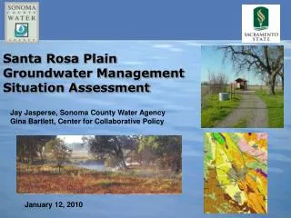
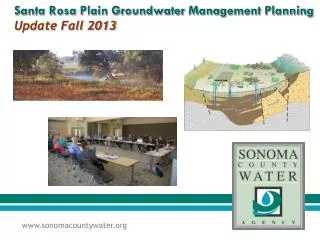
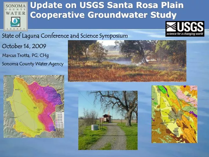
Update on USGS Santa Rosa Plain Cooperative Groundwater Study. State of Laguna Conference and Science Symposium October 14, 2009 Marcus Trotta, PG, CHg Sonoma County Water Agency. Alexander Valley Study Area Completed 2006. Santa Rosa Plain Study Area Initiated 2005.

E N D
Update on USGS Santa Rosa Plain Cooperative Groundwater Study State of Laguna Conference and Science Symposium October 14, 2009 Marcus Trotta, PG, CHg Sonoma County Water Agency
Alexander Valley Study Area Completed 2006 Santa Rosa Plain Study Area Initiated 2005 Sonoma Valley Study Area Completed 2006 Petaluma Valley Study Area
Overview of Study and Cooperating Agencies • Santa Rosa Plain Basin Study – 5 Yr Study Began December 2005 • Complete in December 2010 • $2.2 Million ($1.5 M local/$0.7 M USGS) • Cooperating and Funding Agencies: • Sonoma County Water Agency • Cities of Santa Rosa, Rohnert Park, Cotati, Sebastopol, Town of Windsor • County of Sonoma • Cal American Water Co.
Study Objectives Develop an updated assessment of the hydrogeology & geochemistry of the Santa Rosa Plain (SRP). Develop a fully-coupled surface water/groundwater flow model for SRP. Evaluate the hydrologic impacts of alternative ground-water management strategies on the basin. What are efficient strategies for surface-water/ground-water management that will assure the long-term viability of water supply in the SRP?
Santa Rosa Plain – Groundwater Study Tasks • Data Collection, Compilation & Data Management (GIS) • Water Level & Quality, Geologic, Geophysical, & Land Use • Estimate Groundwater Demand Over Time • Data Interpretation and Hydrogeologic Characterization • Geologic Framework Model • Conceptual Model • Water Balance • Fully Coupled Surface Water/Groundwater Flow Model
Land Use Maps & Water Use Estimates - Santa Rosa Plain Historical Land Use • 1959, 1974,1979, 1986, 1999 Water Use Estimates • Water use records - Urban • Per capita – Domestic Non-Urban • Crop Use Factors - Agriculture
Gravelly unit; south of Sebastopol Wilson Grove Formation Upper sand unit; west of Sebastopol • West of Sebastopol, lower very fine-grained sand • North of Sebastopol, massive fine-grained sand • Southeast of Sebastopol, gravelly, grades into Petaluma Formation Fine-grained unit; Whitaker Bluff
3D Hydrogeologic Framework and Hydraulic Properties Compilation Defining heterogeneity in the hydrogeologic units Construction of 3D hydrogeologic framework model and determination of aquifer thickness • Well lithology at 5-m increments • Horizontal extrapolation away from each drill hole • Highly dependent of density of well data 3D framework
Oblique View of Depth to Basement Surface from Geophysics • Nearly 2,000 new gravity measurements in the northern San Francisco Bay area obtained to delineate to estimate the thickness of the valley-fill and volcanic aquifers. • Santa Rosa Plain is underlain by two sedimentary basins (the Windsor and Cotati Basins) about 1 to 2 km deep separated by the Trenton Ridge, a shallow west-northwest-striking bedrock ridge west of Santa Rosa.
SRP Groundwater Quality Sampling Sites • Water quality database– 5,000 records • Inorganic, trace element, nutrient, & misc. parameters • 411 wells • 6 surface-water sites • Database updated with Dept. Public Health data • Database incorporates recent GAMA sampling program
Development of GSFLOWFlow Model • Coupled surface water (PRMS)-groundwater flow (MODFLOW) model • Capable of simulating land surface processes (runoff, evapotranspiration, infiltration) – coupled to groundwater flow • Provides spatially distributed climate, land surface processes (overland flow, retention storage, etc) • Upon completion, USGS will run several scenarios to assess potential future conditions (e.g., climate change) & alternative water management strategies (e.g., groundwater banking)
Watershed Model • Physical characteristics of watersheds • topography • hydrography • vegetation • soils • geology • land use • streamflow gaging records • meteorological data
Inputs include boundary conditions, aquifer properties, streams and lakes, flow barriers, and pumpage Parameter estimation Ground-Water Flow Model
Stakeholder Assessment – Santa Rosa Plain Groundwater Study • In progress – Conducted by Center for Collaborative Policy, California State University, Sacramento. • Impartial assessments of issues and concerns related to groundwater management in the Santa Rosa Plain and to learn if and how stakeholders might want to address these issues. • Conducted confidential interviews with nearly 50 individuals representing over 30 organizations. • Preliminary findings indicate differing interpretations on the value and potential of groundwater management planning as well as a lack of technical understanding of both surface and groundwater resources within the SRP. • Completed assessment expected in late 2009
Acknowledgements/Questions? USGS Personnel • Database/GIS • Kathryn Koczot • Andy Morita • Donna Knifong • Data Collection/Interpretation • Loren Metzger • Chris Farrar • Geologic Modeling • Victoria Langenheim • Robert McLaughlin • Robert Jachens • Lithologic Modeling • Don Sweetkind • Emily Taylor • Modeling • Joe Hevesi • Linda Woolfenden • Diane Rewis • Tracy Nishikawa • Eric Reichard http://ca.water.usgs.gov/user_projects/sonoma/santarosaplain.html