Download
1 / 1
10 likes | 161 Views
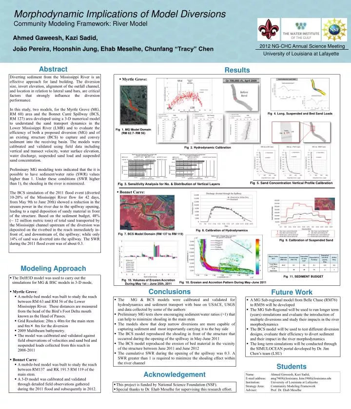
Morphodynamic Implications of Model Diversions Community Modeling Framework: River Model. Ahmed Gaweesh, Kazi Sadid , João Pereira, Hoonshin Jung, Ehab Meselhe, Chunfang “Tracy” Chen. 2012 NG-CHC Annual Science Meeting. University of Louisiana at Lafayette. Abstract. Results.

E N D
Morphodynamic Implications of Model Diversions Community Modeling Framework: River Model Ahmed Gaweesh, KaziSadid, João Pereira, Hoonshin Jung, Ehab Meselhe, Chunfang “Tracy” Chen 2012 NG-CHC Annual Science Meeting University of Louisiana at Lafayette Abstract Results Diverting sediment from the Mississippi River is an effective approach for land building. The diversion size, invert elevation, alignment of the outfall channel, and location in relation to lateral sand bars, are critical factors that strongly influence the diversion performance. In this study, two models, for the Myrtle Grove (MG, RM 60) area and the Bonnet Carré Spillway (BCS, RM 127) area developed using a 3-D numerical model to understand the sand transport dynamics in the Lower Mississippi River (LMR) and to evaluate the efficiency of both a proposed diversion (MG) and of an existing structure (BCS) to capture and convey sediment into the receiving basin. The models were calibrated and validated using field data including vertical and transect velocity, water surface elevation, water discharge, suspended sand load and suspended sand concentration. Preliminary MG modeling tests indicated that the it is possible to have sediment/water ratio (SWR) values higher than 1. Under these conditions (SWR higher than 1), the shoaling in the river is minimized. The BCS simulation of the 2011 flood event (diverted 10-20% of the Mississippi River flow for 42 days, from May 9th to June 20th) showed a reduction in the stream power in the river due to the spillway opening, leading to a rapid deposition of sandy material in front of the structure. Based on the sediment budget, 48% (~ 12 million metric tons) of total sand transported by the Mississippi channel upstream of the diversion was deposited on the riverbed in the reach immediately in-front of, and downstream of, the spillway; while only 14% of sand was diverted into the spillway. The SWR during the 2011 flood event was of about 0.3. • Myrtle Grove: RM63.2Station 2ConcoPhilips Fig 4. Long. Suspended and Bed Sand Loads Fig 1. MG Model Domain (RM 62.7- RM 56) Fig 2. Hydrodynamic Calibration Fig 5. Sand Concentration Vertical Profile Calibration Fig 3. Sensitivity Analysis for No. & Distribution of Vertical Layers • Bonnet Carre: Fig 8. Calibration of Hydrodynamics Fig 7. BCS Model Domain (RM 137 to RM 119) Fig 9. Calibration of Suspended Sand Modeling Approach Fig 11. SEDIMENT BUDGET • The Delft3D model was used to carry out the simulations for MG & BSC models in 3-D mode, • Myrtle Grove: • A mobile-bed model was built to study the reach between RM 63 and RM 56 of the Lower Mississippi River. These distances are measured from the head of the Bird’s Foot Delta mouth known as the Head of Passes. • Grid Resolution: 20m x 40m for the main stem and 8m× 8m for the diversion • 2009 Multibeam bathymetry. • The model was calibrated and validated against field observations of velocities and sand bed and suspended loads collected from this reach in 2008-2011 • Bonnet Carre: • A mobile-bed model was built to study the reach between RM137 and RK 191.5 RM 119 of the main stem. • A 3-D model was calibrated and validated through detailed field observations gathered during the 2011 flood and subsequently in 2012. Fig 10. Volumes of Erosion/Accretion During May 1st – June 25th, 2011 Fig 10. Erosion and Accretion Pattern During May–June 2011 Conclusions Future Work • The MG & BCS models were calibrated and validated for hydrodynamics and sediment transport with base on USACE, USGS and data collected by some of the authors • Preliminary MG tests show encouraging sediment/water ratios (>1) that can help to minimize shoaling in the main stem • The models show that deep narrow diversions are more capable of capturing sediment and most importantly carrying it to the bay side • The BCS model reproduced the shoaling in front of the structure that occurred during the opening of the spillway in May-June 2011 • The BCS model reproduced the erosion of bed material in the vicinity of the structure between June 2011 and June 2012 • The cumulative SWR during the opening of the spillway was 0.3. A SWR greater than 1 is required to minimize the shoaling effect within the river channel • A MG Sub-regional model from Belle Chase (RM76) to RM56 will be developed • The MG Sub-Regional will be used to run longer term (years) simulations and evaluate the introduction of multiple diversions and study their impacts in the river morphodynamics • The BCS model will be used to test different diversion designs, evaluate their efficiency to divert sediment and their impact in the river morphodynamics • The long term simulations will be conducted through the SIMULOCEAN portal developed by Dr. Jim Chen’s team (LSU) Students Acknowledgement Name: Ahmed Gaweesh, KaziSadid, E-mail address: amg7469@louisiana, kms1960@louisiana.edu Institution: University of Louisiana at Lafayette Strategy Area: Community Modeling Framework Advisor: Prof. Dr. EhabMeselhe • This project is funded by National Science Foundation (NSF). • Special thanks to Dr. EhabMeselhefor supervising this research effort.