Download

1 / 18
180 likes | 283 Views
DETERMINING LAND DEVELOPMENT EFFECT ON SURFACE RUNOFF USING GIS. Objectives. To assess the changes in water flow due to development Validate USGS Data and Hydrology Analysis Tools. Study Area Location. Study Area (Continued). Data. Bureau of Transportation Statistics (BTS) Road

E N D
DETERMINING LAND DEVELOPMENT EFFECT ON SURFACE RUNOFF USING GIS
Objectives • To assess the changes in water flow due to development • Validate USGS Data and Hydrology Analysis Tools
Data • Bureau of Transportation Statistics (BTS) Road • National Land Cover Dataset (NLCD) 2001 – Land Cover • National Elevation Dataset (NED) 1/3 Arc Second • Digitized Land Development Data
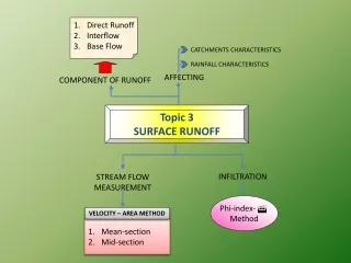
Surface Runoff Calculation Q = C*i*A Q = Peak Flow (volume/time) C = Runoff Coefficient (dimensionless) i = Rainfall intensity (depth/time) A = Drainage Area (area)
Conclusion • New development in the study area could cause as much as 30% increase in water flow in some areas • USGS Data & Hydrology Analysis yielded reasonable results • The methodology could be used to assess the need for public agencies to proactively address future developments
Study Limitations &Future Study Suggestions • Proposed Grade (elevation) of New Development assumed unchanged • More recent Land Cover Data • Proposed Development is assumed as a single Land Cover Category • Effects of existing/proposed pour points are ignored